|
MESA VERDE
Environment of Mesa Verde, Colorado Wetherill Mesa Studies |

|
Chapter 5
the environment and the prehistoric occupation
Information on the soils, climate, and vegetation of Mesa Verde contributes to an understanding of the settlement pattern and farming practices of the Pueblo Indians who lived here prehistorically. The techniques of many disciplines, including floristics, palynology, and dendroclimatology, have all been brought to bear on these cultural problems.
EVIDENCE OF PREHISTORIC CLIMATE
Identification of plant remains recovered in the excavation of certain cliff dwellings on Wetherill Mesa indicates a flora similar to that of today (Welsh, MS.). In a preliminary statement, Schoenwetter (MS.) reported that the fossil pollen record gave no indication that a major climatic change has occurred since the Indians withdrew from the area at the end of the 13th century. According to a later report by Martin and Byers (1965, p. 122), "The main stratigraphic event in the pollen sequence of the last 1,000 years is a relative increase in juniper and pine pollen following abandonment 700 years ago." Although this increase may also reflect a minor climatic change, it is probably "the result of secondary plant succession with juniper and then pinyon invading fields when human disturbance ended" (ibid.). Paleoclimatic studies by Fritts, et al. (1965) were based upon the interpretation of present and past growth patterns in pinyon, Utah juniper, and Douglas-fir. Tree-ring chronologies for these species indicate that intense droughts occurred throughout the time of Pueblo occupation and well into the 17th century. These dry periods have not been surpassed since then.
In light of these data and studies, it would appear that the climate of today approximates that of the 13th century in most significant aspects.
INFLUENCE OF ENVIRONMENT ON THE PUEBLOAN CULTURE
The prehistoric sites of Mesa Verde are not distributed uniformly over the plateau but are concentrated in a belt along the 7,000-foot contour, about midway between the Mancos River canyon and the escarpment of the North Rim (Hayes, 1964). This concentration was doubtless the result of many factors, including those of vital concern to an agrarian people—water from seeps and springs; large areas of deep, fertile soil; and moderate climate. The environment of the middle mesa-top site, M—2, may be considered most typical of that in which the aborigines spent munch of their time. There is no direct evidence to prove that the Indians farmed the middle mesa top, but archeologists feel strongly that they did. This central belt has extensive, deep soils with more than adequate nutrients. The lower end of the mesa may have been too hot and dry for farming, and the higher parts may have lacked adequate soil.
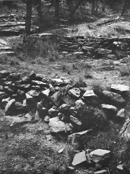
There is ample evidence of farming in the washes and gullies of the mesa rims and on the canyon slopes. As the population grew, it is reasonable to assume that some marginal areas, places difficult to till, had to be exploited in the production of food, primarily maize, beans, and squash. Consequently, systems of check dams and farming terraces were constructed wherever possible. According to Rohn (1963, p. 442), each check dam consisted of rough-hewn sandstone blocks stacked across a small, intermittent stream channel to form a thick wall with a marked upstream batter and a level top course. Such a system trapped the runoff water, causing fine soil particles and organic debris to be deposited behind the stone walls. Parts of some hillsides were also terraced, occasionally in conjunction with the systems of check dams in the erosional channels. These terraces used available moisture to advantage and undoubtedly increased the annual harvests considerably.
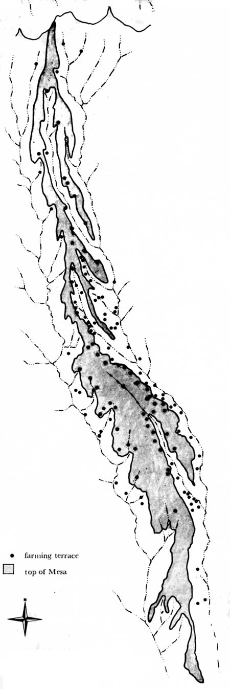
The distribution of farming terraces was studied to determine whether the use of those slopes and mesa rims that harbor more favorable moisture regimes was intentional. The distribution pattern of terraces on Wetherill Mesa, mapped during the archeological survey (Hayes, 1964), is shown in figure 21. The pattern indicates that the more mesic canyon and mesa slopes were selected for agricultural purposes. Of the terrace systems on talus slopes, about 75 percent of the sites surveyed have a northeastern exposure and about 25 percent of the sites have a southwestern exposure. Even more revealing are the "contour" terraces—extensive hillside steps not unlike those found today in the Orient and in the vineyards of Europe—which are found, with few exceptions, on the northeastern exposures of Wetherill Mesa. (Discussions in ch. 4 give some information that may explain this apparent preference for northeastern exposures as locations for farming plots.)
|
| Fig. 21 Map showing locations of prehistoric farming terraces on Wetherill Mesa and in adjacent canyons. |
The combination of favorable temperature conditions, as a result of exposure and the stratification of thermal zones, slightly higher humidity, and adequate soil moisture on the northeastern slopes create what may be the most favorable environment for maize agriculture in the entire Mesa Verde.
There is no direct evidence that the canyon floors were cultivated. We might conclude that cold-air drainage makes this habitat unsuitable for maize and other vegetables, but some check dams at the base of talus slopes near the canyon floors suggest that farming may have been at least marginal in these places. Moreover, soil moisture conditions here may have been more favorable than they are today, for Reed's (1958, pp. 615-167) investigations in Mancos Canyon suggest that the present-day terraces in Mesa Verde were the alluvial floors of the canyons in prehistoric times. The arroyo cutting which produced the present terraces may have started as late as 1880.
Farming sites along the mesa-top rims are also predominantly on northeastern exposures (fig. 21). Sixty percent of those surveyed face approximately northeast, while 40 percent have a southwestern exposure. The northeast-facing sites receive less insolation, and late-lying snow beds improve moisture conditions in the soil.
In conclusion, it appears that the Pueblo Indian farmers deliberately selected the more mesic exposures wherever possible. We do not know if the choice was made by reasoning that crops would grow best where snow persisted longer and temperatures were more favorable, or whether it was arrived at by trial-and-error. Perhaps trial-and-error was supplemented by increased knowledge of the landscape and by observations of crop growth throughout the seasons. From what clues we have as to their farming practices, it is evident that these people were skilled in the management of their most priceless natural resources—soil and water.
| <<< Previous | <<< Contents>>> | Next >>> |
archeology/7b/chap5.htm
Last Updated: 16-Jan-2007