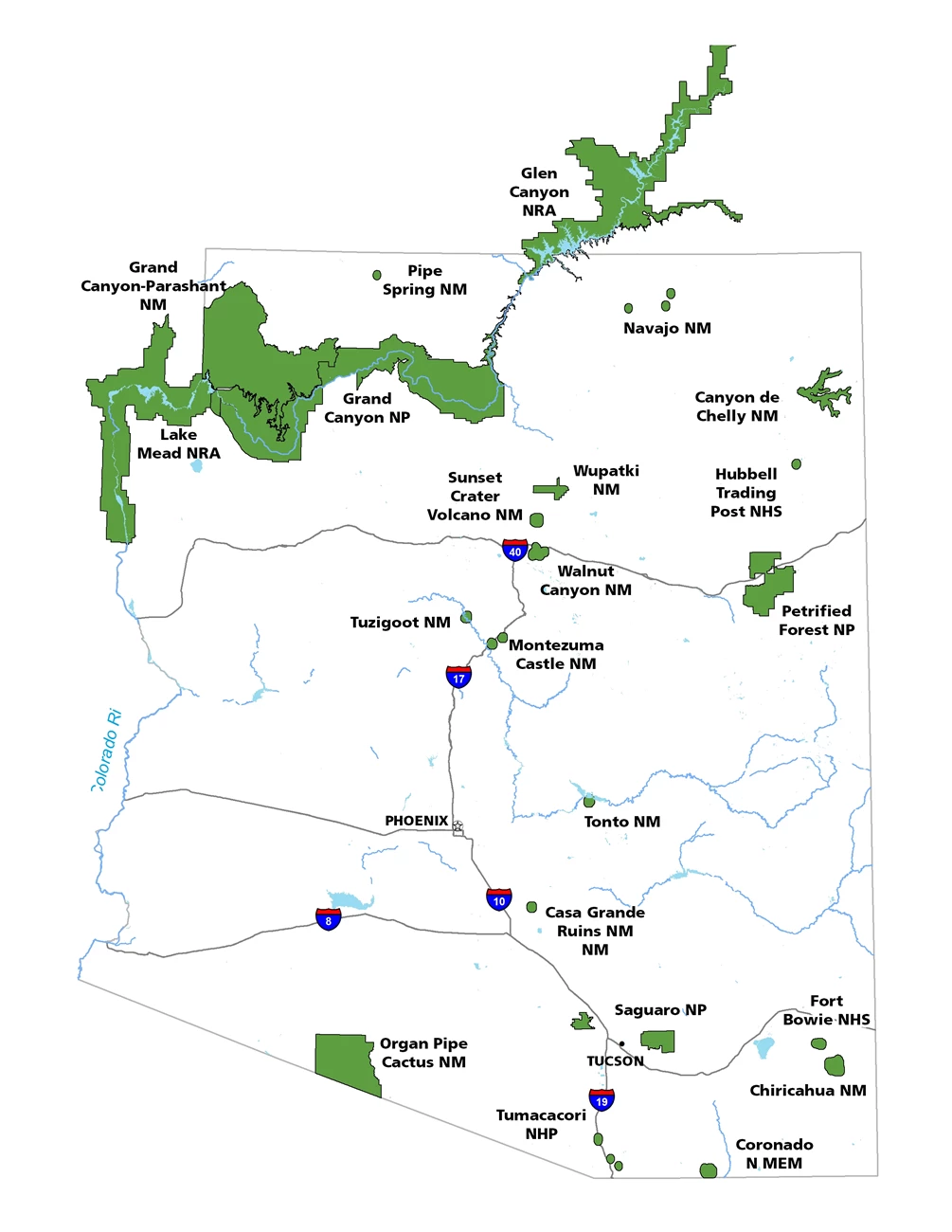
Where do you want to go? Check out the Arizona map or all your options below!
*A note about time zones: Arizona does not follow daylight savings time, however the Navajo Nation does. Please plan accordingly as you travel across northern Arizona!

NPS Photo/Betts
NATIONAL MONUMENT
Canyon De Chelly
Chinle, AZ
For nearly 5,000 years, people have lived in these canyons - longer than anyone has lived uninterrupted anywhere on the Colorado Plateau. Their homes and images tell us their stories. Today, Navajo families make their homes, raise livestock, and farm the lands in the canyon. The National Park Service and Navajo Nation actively work together to manage park resources.

NPS Photo
NATIONAL MONUMENT
Casa Grande Ruins
Coolidge, AZ
Explore the mystery and complexity of an extended network of communities and irrigation canals. An Ancient Sonoran Desert People's farming community and "Great House" are preserved at Casa Grande Ruins. Whether the Casa Grande was a gathering place for the Desert People or simply a waypoint marker in an extensive system of canals and trading partners is but part of the mystique of the Ruins

NPS Photo
NATIONAL MONUMENT
Chiricahua
Willcox, AZ
A "Wonderland of Rocks" is waiting for you to explore at Chiricahua National Monument. The 8-mile paved scenic drive and 17-miles of day-use hiking trails provide opportunities to discover the beauty, natural sounds, and inhabitants of this 11,985 acre site. Visit the Faraway Ranch Historic District to discover more about the people who have called this area home.

NPS Photo
NATIONAL MEMORIAL
Coronado
Hereford, AZ
It was a journey of conquest, filled with exploration, wonder, and cruelty. Inspired by tales of vast cities of gold, 339 European soldiers and over 1100 Indian allies embarked on an epic journey through arid deserts and rugged mountains. They brought rich traditions and new technology into the region, irrevocably changing the lives of native peoples and continuing to influence the area today.

NPS Photo
NATIONAL HISTORIC SITE
Fort Bowie
Willcox, AZ
Fort Bowie commemorates the bitter conflict between Chiricahua Apaches and the U.S. military - a lasting monument to the bravery and endurance of U.S. soldiers in paving the way for settlement and the taming of the western frontier. It provides insight into a "clash of cultures," a young nation in pursuit of "manifest destiny," and the hunter/gatherer society fighting to preserve its existence.

NPS Photo/Moffit
NATIONAL RECREATION AREA
Glen Canyon
Glen Canyon National Recreation Area, AZ,UT
Encompassing over 1.2 million acres, Glen Canyon National Recreation Area offers unparalleled opportunities for water-based & backcountry recreation. The recreation area stretches for hundreds of miles from Lees Ferry in Arizona to the Orange Cliffs of southern Utah, encompassing scenic vistas, geologic wonders, and a vast panorama of human history.

NPS Photo
NATIONAL PARK
Grand Canyon
Grand Canyon, AZ
Unique combinations of geologic color and erosional forms decorate a canyon that is 277 river miles (446km) long, up to 18 miles (29km) wide, and a mile (1.6km) deep. Grand Canyon overwhelms our senses through its immense size.

NPS Photo/McIntyre
NATIONAL Monument
Grand Canyon-Parashant
St. George, UT
Grand Canyon Parashant's natural splendor provides a sense of solitude to those who venture into its isolated domain. Located on the edge of one of the most beautiful places on earth, the Grand Canyon, the Monument's expansive landscape encompasses a chronicle of natural and cultural history.

NPS Photo
NATIONAL HISTORIC SITE
Hubbell Trading Post
Ganado, AZ
The squeaky wooden floor greets your entry into the oldest operating trading post on the Navajo Nation. When your eyes adjust to the dim light in the "bullpen" you find you’ve just entered a mercantile. Hubbell's has been serving Ganado selling groceries, grain, hardware, horse tack, coffee and Native American Art since 1878. Discover Hubbell Trading Post NHS, where history is made every day.

NPS Photo
NATIONAL HISTORIC TRAIL
Juan Bautista de Anza
Nogales, AZ to San Francisco, CA, AZ,CA
"Everyone mount up!" was the rousing call from Juan Bautista de Anza. In 1775-76, Anza led some 240 men, women, and children on an epic journey to establish the first non-Native settlement at San Francisco Bay. Today, the 1,200-mile Juan Bautista de Anza National Historic Trail connects history, culture, and outdoor recreation from Nogales, Arizona, to the San Francisco Bay Area.

Andrew Cattior
NATIONAL RECREATION AREA
Lake Mead
the Mojave Desert, AZ,NV
Lake Mead NRA offers year-round recreational opportunities for boaters, swimmers, fishermen, hikers, photographers and sightseers. It is also home to thousands of desert plants and animals, adapted to survive where rain is scarce and temperatures soar.

NPS Photo
NATIONAL MONUMENT
Montezuma Castle
Camp Verde, AZ
Today we gaze through the windows of the past into one of the best preserved cliff dwellings in North America. This 20 room high-rise apartment, nestled into a towering limestone cliff, tells a story of ingenuity, survival and ultimately, prosperity in an unforgiving desert landscape. Come marvel at this enduring legacy of the Sinagua culture and reveal a people surprisingly similar to ourselves.

NPS Photo/Rikimer
NATIONAL MONUMENT
Navajo
Black Mesa, AZ
The prehistoric Puebloan Ancestors built Tsegi Phase villages within the natural sandstone alcoves of our canyons. The resilient Ancestral Puebloans paved the way for current Native American groups in the Southwest region. These villages, which date from AD 1250 to 1300, thrill all who visit with original architectural elements such as roof beams, masonary walls, rock art, and hand and foot holds.

NPS Photo
NATIONAL HISTORIC TRAIL
Old Spanish
AZ,CA,CO,NV,NM,UT
Follow the routes of mule pack trains across the Southwest on the Old Spanish National Historic Trail between Santa Fe, New Mexico, and Los Angeles, California. New Mexican traders moved locally produced merchandise across what are now six states to exchange for mules and horses.

NPS Photo
NATIONAL MONUMENT
Organ Pipe Cactus
Ajo, AZ
Look close. Look again. The sights and sounds of Organ Pipe Cactus National Monument, an International Biosphere Reserve, reveal a thriving community of plants and animals. Human stories echo throughout this desert preserve, chronicling thousands of years of desert living. A scenic drive, wilderness hike,or a night of camping will expose you to a living desert that thrives.

NPS Photo
NATIONAL PARK
Petrified Forest
Petrified Forest National Park, AZ
Did you know that Petrified Forest is more spectacular than ever? While the park has all the wonders known for a century, there are many new adventures and discoveries to share. There are backcountry hikes into areas never open before such as Red Basin and little known areas like the Martha's Butte. There are new exhibits to bring the stories to life. Come rediscover Petrified Forest!

NPS Photo/Kida
NATIONAL MONUMENT
Pipe Spring
Fredonia, AZ
American Indians, Mormon pioneers, plants, animals, and many others have depended on the life-giving water found at Pipe Spring. Learn about pioneer and Kaibab Paiute life by exploring the museum, historic fort and cabins, garden, orchard, and Ridge Trail. Visit with rangers, ranch animals, and attend living history demonstrations and talks.

NPS Photo/Shattuck
NATIONAL PARK
Saguaro
Tucson, AZ
Tucson, Arizona is home to the nation's largest cacti. The giant saguaro is the universal symbol of the American west. These majestic plants, found only in a small portion of the United States, are protected by Saguaro National Park, to the east and west of the modern city of Tucson. Here you have a chance to see these enormous cacti, silhouetted by the beauty of a magnificent desert sunset.

NPS Photo/Ullmann
NATIONAL MONUMENT
Sunset Crater Volcano
Flagstaff, AZ
Sunset Crater Volcano! Roughly 900 years ago, the eruption of this volcano reshaped the surrounding landscape, forever changing the lives of people, plants and animals. Hike the trail through the lava flow and cinders and you’ll likely discover colorful, ruggedly dramatic geological features coexisting with twisted Ponderosa Pines and an amazing array of wildlife.

NPS Photo
NATIONAL MONUMENT
Tonto
Roosevelt, AZ
The Salado Phenomena, 700 years ago, blended ideas of neighboring Native American cultures to emerge a unique and vibrant society. Tonto National Monument showcases two Salado-style cliff dwellings. Colorful pottery, woven cotton cloth, and other artifacts tell a story of people living and using resources from the northern Sonoran Desert from 1250 to 1450 CE.

NPS Photo/Wolfe
NATIONAL HISTORICAL PARK
Tumacácori
Tumacácori, AZ
More than just adobe, plaster, and wood, these ruins evoke tales of life and land transformed by cultures meeting and mixing. Father Kino’s 1691 landmark visit to an O’odham village when he established Mission Tumacácori was just one event among many. Wave after wave of change has swept or crept across this realm - this land and its people are not static. Come visit and experience this heritage.

NPS Photo
NATIONAL MONUMENT
Tuzigoot
Clarkdale, AZ
Crowning a desert hilltop is an ancient pueblo. A child scans the desert landscape for the arrival of traders. What riches will they bring? What stories will they tell? From the rooftop of the Tuzigoot pueblo it is easy to imagine such a moment. The pueblo shows us this ancient village built by the Sinagua people. They were farmers and artists with trade connections that spanned hundreds of miles.

NPS Photo
NATIONAL MONUMENT
Walnut Canyon
Flagstaff, AZ
Come gaze across the curved canyon walls! Among the remarkable geological cliff formations of the canyon itself, the shapes of the former homes of ancient inhabitants of Walnut Canyon are easily evident. On a hike along the Rim or Island Trails you can imagine what life was like along and within Walnut Canyon while visiting actual pueblos and walking in the steps of those who came before us.

NPS Photo
NATIONAL MONUMENT
Wupatki
Flagstaff, AZ
Nestled between the Painted Desert and ponderosa highlands of northern Arizona, Wupatki is a landscape of legacies. Ancient pueblos dot red-rock outcroppings across miles of prairie. Where food and water seem impossible to find, people built pueblos, raised families, farmed, traded, and thrived. Today, if you linger and listen, earth and artifacts whisper their stories to us still.

NPS Photo
NATIONAL HERITAGE AREA
Yuma Crossing
Yuma, AZ
A river heritage The Colorado River crossing at Yuma, Arizona, has a rich history, accented in recent years by irrigation works that have transformed the region into an agricultural oasis. But in the process, riparian areas suffered and the riverfront became blighted. Today, Yuma Crossing National Heritage Area is working to restore the region’s wetlands and reconnect to the city.
Last updated: September 3, 2024