An official website of the United States government
Here's how you know
Official websites use .gov A
.gov website belongs to an official government
organization in the United States.
Secure .gov websites use HTTPS A
lock (
) or https:// means you've safely connected to
the .gov website. Share sensitive information only on official,
secure websites.
Rain continued this week along the Olympic Peninsula, swelling the Elwha River and moving even more sediment downstream and into the Strait of Juan de Fuca. Last Saturday, streamflow peaked at just under 7,000 cubic feet per second (cfs) and turbidity, a measure of suspended sediment in the water, reached almost 1,600 FNU (Formazin Nephelometric Units). In comparison, streamflow averaged 800 cfs during the dry summer months and turbidity remained below 500 FNU.
The high flows and high turbidity are bringing dramatic changes to the Elwha. As the sediment moves downstream it is filling pools, creating new beaches, building sand bars, and reshaping the river.
A sediment plume is visible at the mouth of the Elwha River, where it meets the Strait of Juan de Fuca.
Courtesy of Tom Roorda
Rebuilding a Forest
Approximately 800 acres of riparian and lowland forest communities were covered by Lake Mills and Lake Aldwell when the Elwha and Glines Canyon dams were built. As part of the restoration of the Elwha, revegetation crews will reseed and replant up to seventy percent of the newly exposed landscape over the next five years.
Since dam removal began, over 46,000 seedlings have already been planted in the two reservoirs. In October and November, park staff, along with two Washington Conservation Corps crews, the Lower Elwha Klallam Tribe, and a team of volunteers, seeded 32 acres and planted approximately 16,800 seedlings in the drained Lake Aldwell and Lake Mills reservoirs. In time, these plants, along with those from natural seeding, will grow into a forest that will stabilize the land and provide vital habitat for fish, birds, and other riparian and upland animals.
New Bat Gates at Glines Canyon Dam
This week crews at Glines Canyon Dam prepared the penstock tunnel, which once carried water from the reservoir to the powerhouse, for some new hardware. The tunnel, which will remain after dam removal, is being fitted with a bat gate. The gate will allow bats to access the tunnel while keeping people and other large animals safely outside.
Want to learn more about the dam's design? Click here to see historic engineering drawings of the two dams.
Experience Elwha River Restoration
The third installment of the Restoration of the Elwha webisode series by Wings over Watersheds is here! "Stepping Down the Dams" goes behind the scenes of dam removal and restoration efforts during the first year of the project. Learn more about the work being done by project managers, sediment scientists, and fisheries biologists working on this unprecedented project. Click here to watch the video.
If you are in the Port Angeles area on Tuesday, December 11, spend an evening with Elwha River Restoration Hydrologist Andy Ritchie at Olympic National Park's Perspectives series. Andy will discuss the Elwha River Restoration project and share his experience monitoring and managing sediment flow on the Elwha. This free public program begins at 7:00 p.m. at Olympic National Park Visitor Center in Port Angeles.
November 21, 2012
Giving Thanks Today, the sun came out and blue skies peeked through clouds that have shrouded Elwha Valley since the rain began. At Glines Canyon, the Elwha River flows over the remains of the dam and the construction site is quiet while the Barnard crew takes a much deserved break for the Thanksgiving holiday. Thanks to this amazing crew, who has been working six to seven days a week, Elwha River Restoration and dam removal is well ahead of schedule.
The Elwha River flows through Goblin Gates, upstream of Glines Canyon Dam.
Photo courtesy of John Gussman.
November 16, 2012
A Trip Down the Elwha
Members of the sediment team float down the Elwha River in rafts outfitted with specialized equipment to monitor sediment redistribution.
Photo courtesy of John Gussman
Photo courtesy of John Gussman
With all of the sediment moving downstream during the last month, there has been a lot of curiosity about the resulting changes to the former reservoirs and Elwha River channel. Last week the sediment team gathered along the Elwha River to survey the river and former reservoirs and determine how sediment is responding to dam removal.
The team began their survey where the river once entered Lake Mills and hiked the length of the former reservoir to Glines Canyon Dam. As they hiked, they measured the surface elevation of the river and collected sediment samples to determine the size of sediment moving downstream and out of the reservoir.
The next day the team floated down the Elwha River in rafts outfitted with specialized equipment to study channel topography and sediment redistribution along the lower stretch of the river. The equipment was used to collect data on the location and elevation of sediment in the river, the velocity and depth of the river, and the size and distribution of sediment along the river bottom.
Finally, the team traversed the lakebed of former Lake Aldwell to survey the newly exposed landscape in order to better map the river channel.
It will be a while before all of the data has been analyzed. Initial observations, though, show that the project is going according to plan; the river is keeping pace with dam removal and effectively eroding sediment downstream and out of the former Lake Mills area.
What a difference a month makes. Images of the Elwha River taken by the new Altair Bridge webcam on October 12 and November 16.
New Webcam at Altair Bridge A new webcam was installed on Altair Bridge last month. The camera is photographing the middle stretch of the Elwha River, between the Glines Canyon and Elwha dam sites. Images captured by this webcam are now up on Flickr for public viewing. Watch as fall and winter rain showers bring new changes to the Elwha River at the Altair Bridge Webcam Flickr page.
Construction Update
At Glines Canyon Dam all sediment-releasing work remains on hold for the November-December 'fish window'. This week crews continued to work on construction of the upstream and downstream penstock barriers and removal the last of the intake tower. Next week the team will take a well-deserved break for the Thanksgiving holiday.
November 8, 2012
Fall Rainshowers Move More Sediment Downstream and Signal the Start of Planting and Spawning
This week fisheries biologists are monitoring the return of coho and chum salmon to the Elwha River and its tributaries; revegetation crews have begun planting in the exposed sediments of the former Lake Mills and Lake Aldwell; and two of the Elwha River webcams are capturing new views of the project.
Rain falls on the Elwha River as it flows past Griff Creek.
Coho and Chum Return to the Elwha With the recent high flows and increased turbidity in the lower section of the Elwha River, scientists are keeping a close eye on the coho and chum salmon scheduled to migrate upstream to spawn this month. Up to 5,000 coho and 200 chum are projected to return to the Elwha River during the November/December spawning season. Although turbidity is high, approximately 300 coho and a handful of chum have already found their way upstream and into the clear waters of the Lower Elwha Klallam Tribal Hatchery and Washington State rearing channel - enough to preserve this year's run.
The long-awaited sediment flushing downstream is an outcome of the project that scientists and project managers have planned for and anticipated. Construction 'fish windows' and hatcheries are two tools that help minimize the sediment impacts to spawning fish and preserve the runs. In the long-term, the benefits from the sediment for these species will be great. The historic lack of downstream sediment, including spawning gravels, may have played a critical role in reducing the Elwha chum population to an annual run of 200-500 adults. After removal of the dams, both chum and coho populations are expected to reach upwards of 16,000 spawning fish over the next 15-20 years. Learn more about coho and chum at https://www.nps.gov/olym/naturescience/anadromous-fish.htm.
Rain didn't stop a Washington Conservation Corps (WCC) crew planting seedlings along riverbanks once covered by Lake Mills.
Planting Begins Again on Former Reservoirs Fall planting has begun along the banks of the Elwha River at the former sites of Lake Mills and Lake Aldwell. Park staff, with the help of two WCC crews, the Lower Elwha Klallam Tribe, and a team of dedicated volunteers, will plant approximately 47,000 seedlings, representing 47 native species, between now and next March. Species being planted this month include big-leaf maple, red alder, black cottonwood, thimbleberry, Scouler's willow, snowberry, and oceanspray.
While some sites will reseed naturally from seed that blows in from surrounding forests or floats down the Elwha River, much of the newly exposed sediment does not have a ready source for new seeds and are far from native seed sources. The woody seedlings being planted this month, along with 5,000pounds of grass and wildflower seeds that were sowed last month are vital to successful revegetation of the area. In time, these plants, along with those from natural seeding, will grow into a forest that will stabilize the land and provide vital habitat for fish, birds, and other riparian and upland animals.
View from new webcam location upstream of Glines Canyon Dam
Two New Views of the Elwha River Restoration Project The Elwha River webcams are providing a few new views of the project this week. Two of the six webcams have recently been relocated. The webcam at Glines Canyon Dam was repositioned to provide a better view of lower section of the dam during the final stages of dam removal and the webcam formerly located at the Elwha Dam site has been moved to a new location along the edge of former Lake Mills. Peek behind the scenes at: http://video-monitoring.com/construction/olympic/js.htm
High Flows and High Turbidity Continue Increased precipitation has made for high flows and high turbidity in the Elwha River. This week the volume of water moving downstream peaked at just under 5,000 cfs (cubic feet per second) and turbidity peaked at almost 1,500 FNU (Formazin Turbidity Unit). While the volume sediment moving downstream is twice the average for this time of year, it is in accord with quantities project managers and scientists expect and well within the capacity of the water treatments downstream.
November 2, 2012 High Water Moves More Sediment Downstream
Elwha River surges over the remains of Glines Canyon Dam following two days of heavy rain.
Turbidity at Glines Canyon Dam
Fall has returned; and with it has come the rain. For the last two weeks, a steady stream of rain showers has swelled the Elwha River and dramatically increased the quantity of sediment flowing downstream. With the last of Lake Mills now drained, the river can move larger sediment over the dam and scientists expect the sediment release over the next two months to be the largest to date.
Over 24 million cubic yards of sediment accumulated in the reservoirs of Lake Mills and Lake Aldwell since the construction of the Elwha and Glines Canyon dams. Thirty to fifty percent of this sediment is expected to erode downstream over the next three to six years. During the November/December hold period, scientists anticipate up to a 20 year supply of sand and a 5 year supply of gravel and cobble will be released downstream.
Turbidity, water cloudiness caused by suspended particles, is one measure hydrologists use to monitor the sediment release. In the last two weeks turbidity in the Elwha River downstream of Glines Canyon Dam has peaked at approximately 1,500 FNU. During the dry summer months, June through mid-October, the turbidity of the Elwha River was consistently less than 500 FNU.
The high turbidity means the rain and resulting high river flows are doing exactly what project scientists, engineers, and managers hoped and planned for - cutting into the banks and sand bars upstream of the former dam sites and moving clay, silt, sand, coarse sediment, and woody debris downstream. As the high flows continue, scientists will be closely monitoring sediment movement and its associated effects on aquatic life downstream, as well as changes to river topography and coastal bathymetry.
Dam Removal Update At Glines Canyon Dam all sediment-releasing work has been stopped for the November-December 'fish window' to help protect chum and coho salmon returning to the river to spawn. Next week crews will continue to haul away concrete rubble removed from upstream of the dam and construct the upstream and downstream penstock barriers, as weather and conditions allow. Downward notching of the remaining dam will resume in January.
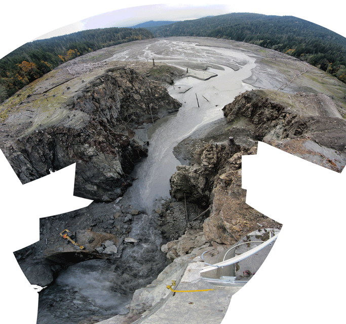
Final Drawdown of 2012 Makes the Elwha a River Once More
October 26, 2012
This fish-eye image was captured shortly after a controlled blast on October 24 drained the remaining Lake Mills, restoring river flow in the Elwha.
NPS Photo by Andy Ritchie
The Elwha flows through the newly created notch (lower right) which brought the channel elevation to 450 feet, just 50 feet above the original channel bed.
URS Corporation
Although another 65 vertical feet of Glines Canyon Dam are still standing, Wednesday's controlled blast removed enough of the dam to drain the remaining pool of Lake Mills. In the words of project hydrologist Andy Ritchie, "she's all river now."
Wednesday's blast opened a new 22'-wide notch in the dam, lowering the active river channel to elevation 450 feet. When the dam is completely gone, the final river channel will be approximately elevation 400 feet.
With the disappearance of the last of Lake Mills, sediment is once more flowing from the peaks of the Olympics to the Strait of Juan de Fuca. Scientists are now seeing coarser sediments moving downstream from Glines Canyon dam, adding sand and gravel movement to the silt and clay already being transported by the river. New sand deposits can now be seen in the river's middle 'reach', the section between Glines Canyon and the old Elwha Dam site.
A new beach forms along the river edge, just downstream of the much-diminished Glines Canyon Dam.
NPS Photo by Andy Ritchie
The November-December 'fish window' begins on November 1, requiring that the contractor stop all sediment-releasing work to protect fish in the river. Plenty of sediment will still be released however, as fall rains and high river flows carry the sediment deposited on the former lakebeds during the near-century of reservoirs on the Elwha.
The chum and coho salmon expected to return during the upcoming fish window will be impacted by the river's high sediment loads, bringing into focus the value of the multiple safeguards included in the Elwha Fish Restoration Plan. Read more about the species-specific approaches to protecting and restoring fish. You may also download the full Elwha Fish Restoration Plan.
Downward notching of the remaining dam will begin again in January, with complete dam removal anticipated by summer 2013.
Helicopters can move large wood quickly and safely without disturbing the surrounding landscape.
October 5, 2012
Flying Debris at Lake Mills
On Tuesday, a heavy lift helicopter was used to move hundreds of large wood logs from the former shoreline of Lake Mills to the newly exposed landscape below. In less than eight hours, an eight acre area of the former lake was transformed from a barren landscape covered in little more than coarse and fine sediments to a sheltered environment of woody debris to encourage new vegetation to establish and grow.
This woody debris will provide significant benefits to new seedlings attempting to establish in the former reservoir. The wood will help minimize erosion of fine sediments off of slopes, hold moisture in the soil for new seedlings, and provide shade and nutrients to new vegetation taking root in the former lakebed. Woody debris also traps organic materials, seeds, and fine particles blown in by the wind, enhancing natural ecosystem development. Large piles of wood also create barriers to large herbivores, such as deer and elk, which feed on the young seedlings.
Redistributing woody debris to areas of exposed sediments can provide great benefits to new vegetation, but moving the logs can be costly and time consuming. Costs and benefits are carefully considered when selecting the best methods for revegetation efforts. The helicopter operation on Tuesday, which was funded by an EPA grant secured by the Lower Elwha Klallam Tribe, was able to relocate hundreds of logs in less than eight hours - an effort that could take work crews using hand tools several months to achieve. Helicopters are also the only way to move extremely large wood safely and without disturbing the surrounding landscape. To ensure the greatest benefit from the operation, the wood was moved to areas of elevated terrain where it is unlikely to be eroded by the river over time.
As dam removal and revegetation efforts continue, additional debris may be moved if funding becomes available.
Woody debris is laid across the exposed landscape of former Lake Mills to encourage new vegetation to establish and grow.
The requested video is no longer available.
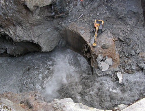
A hydraulic hammer chips away at the intake tower at Glines Canyon Dam.
Blasting to Resume at Glines Canyon Dam
Since Sunday, September 23, a fourteen day hold has been in effect at Glines Canyon Dam. During this time, crews continued the demolition of the intake tower and removed concrete rubble that had accumulated upstream of the dam during the removal process. The former Glines Transformer Yard and Power house areas were also hydroseeded and just need some rain to sprout new grass.
Blasting to lower the dam is scheduled to resume on Monday, October 8. In addition to lowering the dam, crews will continue to remove concrete debris piled upstream of the dam. This next blast will draw down the reservoir from 473 to 465 feet. A second blast is expected to occur latter next week to provide an overflow path for the river during higher winter flows.
September 28, 2012
From a Wall of Water to a Wall of Sediment
For 85 years Glines Canyon Dam trapped up to 30,000 acre-feet of water in the Lake Mills reservoir. Soon, the reservoir will be completely gone and only a river and a thick layer of sediment will remain.
Although a small pool of water can still be seen behind the dam, the level of the water in the remaining reservoir is quickly approaching the same depth as the Elwha River. As the dam removal process continues, crews will encounter less water and more sediment after each blast. Once the reservoir water is gone, a wall of sediment up to 70 feet thick will reach the dam.
The fourteen-day hold periods are critical for managing this sediment. The hold periods allows the river time to erode horizontally across the breadth of the former reservoir area and move the sediments downstream. As each section of the dam is removed, a new gradient is created. As the river follows the slope of the new gradient, it cuts down vertically into the sediment. During fourteen-day hold periods the river first cuts down through the sediment along the new gradient, and then begins to meander laterally and cut into its banks. If the dam is removed too quickly, the river will cut a channel down through the remaining sediments, leaving behind high unstable slopes and a large volume of sediment available for uncontrolled erosion during the next flood.
Currently, the rate of reservoir sediment erosion is keeping pace with the rate of dam removal. Even though September and early October are generally the lowest flow times of the year, the reservoir sediment still erodes vertically in response to each increment of dam removal.
The magnitude of sediment being released during the removal of Glines Canyon Dam is unprecedented. As the dam removal continues, the sediment management team is closely monitoring sediment movement. Continued gradual and controlled removal of the dam will allow the project management team to monitor and respond to changes in sediment behavior and adapt the plan to minimize impacts to the water treatment plants and downstream environment. Want to dig deeper into sediment transport and monitoring in the Elwha? Read more at our Elwha Restoration Docs page.
What remains of Lake Mills in late September 2012.
Photo Courtesy of Tom Roorda
Glines Canyon is slowly revealed as the dam is removed.
Photo courtesy of Tom Roorda
Glines Canyon Dam Update
Last week four blasts lowered the Lake Mills reservoir a total of 12 feet and crews began the process of excavating concrete debris from the upstream side of the dam. The debris has accumulated, as planned, throughout the dam removal process. As chunks of the dam have been removed over the past year (first by barge-mounted hydraulic hammer and later by controlled blasting), most of the concrete dropped into the water on the upstream side of the dam. Excavating or 'mucking out' the concrete debris has always been part of the plan; enough of the dam has been removed now that this part of the process can begin.
On Sunday, September 24, a fourteen day hold began. During the fourteen-day hold crews will muck concrete and prepare for the blasts scheduled to resume on October 8.
The next series of blasts will mark the start of another phase of dam removal. During this upcoming phase, the dam can be lowered up to ten feet at a time, although the rate of removal cannot exceed an average of two feet per day. In addition to lowering the dam, crews will continue to remove concrete debris piled upstream of the dam.
September 21, 2012 Fire at Elwha Dam Site
On Thursday, September 20, at approximately 7:15 p.m., a private citizen reported a fire near the Elwha Dam restoration site. Personnel from Clallam County, Washington Department of Natural Resources, and the park were dispatched to the fire. The fire, measuring approximately half an acre, was contained at approximately 8:30 p.m. The cause of the fire is under investigation.
The private citizen who called 911 observed the fire in photos taken by the Elwha Dam webcam located at the site. The webcam, which can be viewed on the park's website, is one of six used to monitor the process of sediment movement during dam removal on the Elwha River.
Due to the continued hot and dry weather and drying out of forest fuels, the park has instituted a ban on all open fires in the park's wilderness backcountry, effective as of September 21, 2011.
A Little Less of Glines Canyon Dam It has been an explosive week at Glines Canyon Dam. Since the end of the August/September fish window on Friday, September 14, four blasts have been used to continue removal of the dam. Blasts on Saturday, Monday, and Wednesday, September 15, 17, and 19 removed three sections of the dam and lowered the elevation of the reservoir from 489 to 476 feet. A fourth blast on Tuesday was used to remove a remaining section of the dam above the waterline. One additional blast is scheduled for Sunday, September 23. The blast will lower the elevation reservoir an additional three feet.
Following the final blast on Sunday, September 23, a fourteen-day hold will begin. Fourteen-day hold periods are built into the work schedule and occur after each time the reservoir drops 15 feet. During the hold, all reservoir-lowering work is halted to allow time for the river to erode laterally across the newly exposed sediment, moving it out of the old lakebed and downstream where it can replenish beaches and the estuary.
Excavation work in the river upstream of the Elwha Dam is complete. Clean-up of the site will continue over the next couple of weeks, along with seeding and matting of the area.
The requested video is no longer available.
An Exciting Site for Visitors to Former Lake Aldwell A walk along the exposed lakebed of the former Lake Aldwell Reservoir is never the same week to week, or even day to day. The land shifts and changes shape, new plants take root in once bare sediments, and life emerges from the surrounding forest to take advantage of the emerging resources within this dynamic and ever-changing environment. In the last month, visitors to the former reservoir and lower Elwha River have been treated to one more new site - Chinook (king) salmon spawning in the mainstem and side channels of the Elwha River. Since the salmon began entering the Elwha River in June, hundreds of Chinook have made it upstream of the former Elwha Dam, along with a couple of pink salmon.