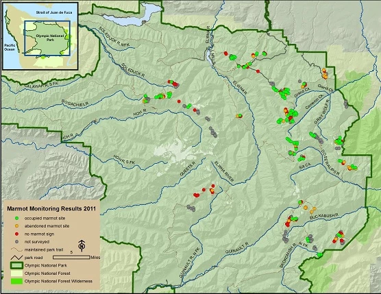
NPS Program Overview and Results of the 2011 Field SeasonThe summer of 2011 was the second full year of the Olympic Marmot Monitoring Program. In spite of the record late season snowfall, the program was again a success; 95 volunteers in 37 groups participated in the program. After training the volunteer surveyors then ventured into the park for 4-7 days, looking for marmots and marmot burrows in high-elevation meadows and rock-fields. GPS units had the survey clusters and units loaded onto to them, assisting the surveyors in getting to the right spot. They were also able to record their routes and mark where they found marmots and marmot sign. Surveyors were able to completely survey 239 units, partially survey 39, and unable to survey 57 others. Of the units that were completely surveyed, 49% were found to be occupied by marmots, where volunteer surveyors either saw marmots or fresh marmot sign. 20% of the survey units were abandoned (surveyors saw past but not recent sign of marmot use), and 31% had no sign of marmots (Figures 3 and 4b). These results are comparable to what was observed in 2010 when 80 volunteers surveyed 260 units, of which 48% were occupied, 27% abandoned, and 25% no sign. 

It is important to remember that the survey units were selected to include a high proportion of habitat patches that we thought contained marmots-so these numbers do not reflect the distribution of occupied marmot habitat park-wide. The great value of this data, however, is that it will allow us to track changes in the percentage and distribution of units occupied by marmots over time. Changes for 2012For only the second year of implementation, the program ran pretty smoothly in 2011. Based on feedback from the 2011 volunteers, our observations, and other developments, the following changes are in store for the program in 2012:

Olympic Marmots
Learn more about the Olympic Marmot. 
Marmot Monitoring Volunteers
Teams of volunteers hike to locations within Olympic National Park to record up-to-date information about the Olympic Marmot. 
Marmot Research, Reports, and Links
Learn more about the research on Olympic Marmots. |
Last updated: July 18, 2024
