Background
Water resources within Big South Fork National River and Recreation Area (BISO) include approximately 80 miles (129 kilometers) of the Big South Fork of the Cumberland River along with its two major tributaries, Clear Fork and New River. In addition, there are hundreds of miles of tributaries and headwater streams within the park’s 125,000 acres. The BISO rivers and streams sustain nationally important freshwater fauna, including 11 federally-listed mussel species and the only population in existence of the federally-endangered tuxedo darter (Etheostoma lemniscatum). Big South Fork National River and Recreation Area supports one of the largest concentrations and some of the most pristine examples remaining of the globally imperiled Cumberlandian cobble bar or riverside scour prairie. These cobble bar prairies and the rare species that inhabit them thrive in the presence of frequent flood disturbance and are dependent upon natural flood regimes and unpolluted water. Big South Fork National River and Recreation Area occupies a small, downstream portion of its large (1,120 square mile) watershed, and therefore, the health of its aquatic systems is dependent to a large degree on external factors.Issues of Management Concern
The primary threats to water quality at Big South Fork National River and Recreation Area are related to acid mine drainage from coal mines, sedimentation associated with roads and trails and historic mining, and impacts from timber harvest, agriculture, water development, and oil and gas activities in the watershed.Monitoring and Objectives
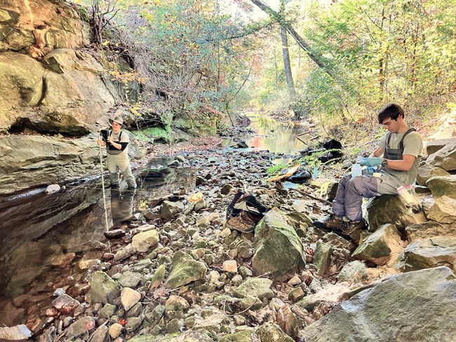
The Appalachian Highlands Inventory and Monitoring Network (APHN) monitors water quality at strategic integrator sites to identify water resource conditions. Over 20 water quality parameters are measured at each sampling site. We use a YSI multisensor sonde to measure readings in the stream. In addition, we collect a water sample using a sampling technique, Equal-Width-Increment, to make sure our sample is depth- and steamflow- integrated and represents the entire stream channel. The sample is separated into aliquots. Some of the aliquots are used for tests in the APHN lab at Big South Fork NRRA and some are sent to the University of Tennessee Department of Civil and Environmental Engineering for further analysis.Current conditions are compared to state and federal standards, as well as natural reference conditions within Big South Fork National River and Recreation Area. For detailed methods, see Hughes et al. 2018.
The network monitors a number of water quality parameters including:
The Big South Fork NRRA has free-flowing waters, where the rivers and streams are largely unimpaired by dams or diversions. Aquatic and riparian species rely on and have adapted to natural flows, including high flood pulses and low water periods. Adequate flows, as well as scouring floods, are necessary for the survival of globally-imperiled cobble bar communities, as well as federally-listed fish, mussels, and plants at BISO. In addition, streamflow plays an important role in water chemistry, nutrient cycling, and geomorphic processes that shape river channels and floodplains.
Tennessee state water quality standards specify that for fish and aquatic life, temperature shall not exceed 30.5°C (86.9°F).
Dissolved oxygen must be above 5.0mg/l to attain Tennessee state water quality standards.
Tennessee water quality standards specify that pH shall remain between 6.0 and 9.0 standard units.
Reference conditions for conductance at Big South Fork NRRA is around 50 uS/cm for streams and 100 uS/cm for rivers. There is no state standard.
APHN's water quality monitoring protocol does not test E.coli at a frequency necessary to meet Tennessee state water quality standards, which specifies two criteria requiring five samples collected within 30 days: a geometric mean of 126 colony forming units (cfu)/100ml and a <10% exceedance of 410cfu/100ml.
The reference condition for E.coli in rivers at Big South Fork NRRA is <100cfu/100ml.
There is no numeric state water quality standard for turbidity in Tennessee.
The EPA ecoregion recommendation is <2.3 Formazin Nephelometric Units (FNU).
While certain metals serve a vital function for biological processes in streams, high concentrations of certain metals can be harmful for aquatic life. For example, aluminum can cause respiratory distress in fish as it builds up on their gills.

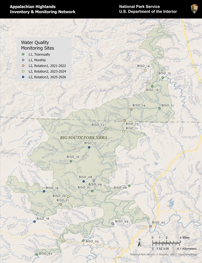
| Site # | Site Name |
| BISO_02 | New River at New River, TN |
| BISO_03 | Clear Fork at Peters Bridge |
| BISO_04 | Clear Fork at Burnt Mill Bridge |
| BISO_05 | White Oak Creek |
| BISO_06 | Pine Creek |
| BISO_07 | North White Oak Creek |
| BISO_09 | Big South Fork at Leatherwood Ford |
| BISO_10 | Laurel Fork of Station Camp Creek |
| BISO_08 | Bandy Creek |
| BISO_11 | Williams Creek |
| BISO_12 | Bear Creek |
| BISO_13 | Roaring Paunch Creek |
| BISO_14 | Rock Creek |
| BISO_15 | Big South Fork at Blue Heron |
| BISO_22 | No Business Creek |
| BISO_17 | Station Camp u/s Laurel Fork |
| BISO_16 | Big South Fork at Yamacraw |
| BISO_18 | Mill Creek near Stockton |
| BISO_19 | Spruce Branch of NWO |
| BISO_20 | Laurel Fork of NOW |
| BISO_21 | North White Oak Creek at Zenith |
| BISO_23 | Difficulty Creek |
| BISO_24 | Troublesome Creek |
Significant Findings
During water year 2024 (WY24), sampling occurred from October 2023 to September 2024. Including QA/QC, 79 samples were collected from 15 sites (see map above), following rotational panel 1 (Hughes et al. 2018). Beginning in WY23, sampling periods were reduced from quarterly to triennially.There were no violations of Tennessee State Water Quality Standards in WY24. Water temperature and dissolved oxygen met all water quality criteria, with temperature remaining below 30.5°C (86.9°F) and dissolved oxygen above 5 mg/l. Water temperature ranged from 1.2°C to 30.0°C with a mean of 16.3°C for all site measurements. Dissolved oxygen ranged from a minimum of 5.2 mg/l to 14.1 mg/l. Mean dissolved oxygen across all sites was 9.6 mg/l.
There are no state standards for conductance. For waters of the Cumberland Plateau, natural reference conditions for rivers are below 100 µS/cm (microsiemens per centimeter) and below 50 µS/cm in smaller streams. Specific conductance was below 100 µS/cm at most sites, ranging from a low of 26.3 µS/cm at Laurel Fork of Station Camp Creek to a maximum of 333 µS/cm at Pine Creek at Toomey Bridge. New River at New River Bridge continued to have elevated conductance levels with a mean of 175 µS/cm. Mean specific conductance for all site measurements was 102.9 µS/cm.
Turbidity was low at most sites (mean = 5.7 FNU [Formazin Nephelometric Units]). Although the overall mean is above the recommended Ecoregion conditions of 2.3 FNU (EPA 2021), median turbidity was closer to this recommendation at 2.8 FNU. New River, Big South Fork at Leatherwood Ford, and Bear Creek were the most turbid sites.

NPS/Emma Brinley Buckley
Nitrate levels in Big South Fork waters were low, with 84% of samples below the minimum detection limits, meaning the amount was too low to quantify. Of the remaining 16% of samples above the detection level, results ranged from 0.06 mg/l to 1.04 mg/l with a mean of 0.31 mg/l. This average meets the EPA’s ecoregion recommendation of 0.31 mg/l. Bear Creek continues to have elevated levels of chloride (mean=23 mg/l) and sodium (18 mg/l), compared to the overall average for all sites at Big South Fork (mean chloride = 3.8 mg/l and mean sodium = 4 mg/l).
Water quality data are available upon request to the Appalachian Highlands Network. Past water quality reports and briefs are available on the Appalachian Highlands Network website.
WY2024 data was collected by technicians Briley Bledsoe and Rhea Hester.
Contact: emma_brinleybuckley@nps.gov

NPS/Emma Brinley Buckley
Last updated: January 14, 2025
