
|
|
|
2007 ESRI UC Displays |
 |
||
|
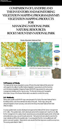
Comparison of LandFire and the Inventory and Monitoring Vegetation Mapping Program (IMVMP) Vegetation Mapping Products For Managing National Park Natural Resources: Rocky Mountain National Park
A document explaining the methods used to develop each map product was also prepared and sent to the park. Once the survey result swere received back in the Remote Sensing and GIS office, they were compiled and summary descriptive calculations were made. 3.0 Study Results. The descriptive numbers that were calculated will give the reader an overall sense or impression as to the comparability of the two products. Table 2 summarizes the survey results. Management suitability scores of zero indicated that the particular category was either left blank or was marked as "not applicable". These scores were left out of the total, mean, and median calculations. Out of a possible overall management utility score of 110, the Landfire map product received a score of 37 (33.6%) and the IMVMP product received a score of 109 (99.1%). The mean management utility score for the Landfire product was 1.68, compared with 4.95 for the IMVMP product. The medians were 1 and 5 respectively. Out of a possible overall map accuracy score of 10, the Landfire product received a score of 2 (20.0%) and the IMVMP product received a score of 10 (100.0%). The median map accuracy score for the Landfire product was 1 and the median score for the IMVMP product was 5. Out of a possible overall survey score of 120, the Landfire mapping product achieved a total score of 39 (32.5%) with a mean score of 1.63, while the IMVMP mapping product achieved a total score of 119 (99.2%) with a mean of 4.96. The Rocky Mountain National Park personnel left the "Implementing a conservation program" and "Other" categories blank and these were not, therefore, included in the compiled statistics. The only categories in which the Landfire data scored well were those devoted to fire fuels, fire modeling, and urban smoke issues. Rocky Mountain National Park personnel generally gave Landfire lower marks for its suitability or usefulness for management activities. The park staff also tended to disagree that the Landfire data were thematically and positionally accurate. By contrast, the IMVMP data scored positively and highly in both areas. 4.0 Rocky Mountain National Park Comments. Rocky Mountain National Park personnel generally gave Landfire lower marks for its suitability or usefulness for management activities. The park staff also tended to disagree that the Landfire data were thematically and positionally accurate. By contrast, the IMVMP data scored positively and highly in both areas.
5.0 Discussion. Rocky Mountain National Park staff showed a preference for the IMVMP maps for nearly all of the categories of park management and also for thematic and positional map accuracy. The Landfire Existing Vegetation data were seen to be primarily useful for fire fighting activities. Content by Douglas R. Clark and David Salas Remote Sensing and GIS Group, Bureau of Reclamation. Links of interest:
For NPS go to inside for more information about the conference |
|||
| ParkNet | US Department of the Interior | FOIA | Privacy Policy | Disclaimer | FirstGov |