
|
|
|
2007 ESRI UC Displays |
 |
|
Impervious Surfaces: An Indicator of Watershed HealthChattahoochee River National Recreation Area, Atlanta GA
The Chattahoochee River NRA was established to protect and preserve the values of the river from "development and other uses that would otherwise impair or destroy them... for the public benefit and enjoyment." Every Day in Atlanta:
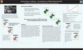
Methods:Using the ArcHydro extension, a flow accumulation model was developed from USGS 10 Digital Elevation Models (DEMs). Then a stream layer was created using a 100ha threshold, which was used to delineate microwatersheds for the park. Remnant and fragment microwatersheds (<100 acres) were joined to the largest adjacent watershed using the ArcGIS toolbox. Percent impervious Area layers for 1991, 2001, and 2005 were obtained from UGA Natural Resources Spatial Analysis Laboratory (NARSAL). The percent impervious area for CRNRA microwatersheds were calculated using Zonal Statistics++ in Hawth's Tools. Percent impervious surface was mapped in a time-series and percent change comparison. Results and Discussion:Despite widespread urbanization, many local park microwatersheds are protected. The fastest growing watersheds are not the most heavily paved ones... YET! In this way, mapping impervious surface cover can be used to show urban sprawl in other metropolitan areas. Percent impervious surface is an effective tool for watershed management because it strongly linked to non-point source pollution. It is also a measure used in zoning and development, making it translatable from natural resources to urban planning. Management of watersheds with low impervious should protect water quality and species diversity, while those with high impervious should be targeted for monitoring of pollution and stormwater runoff and stream restoration projects. Percent imperviousness is related to population density. Future watershed impacts can be predicted using population growth models as related to percent impervious area. Urbanization affects aquatic systems in a variety of ways, including:
The microwatershed analysis allows for a better look at the 'hot spots' of development in the Chattahoochee River NRA watershed. Percent change of impervious surface: The largest increase in impervious surfaces occurs in Big Creek, Johns Creek, and Suwanee Creak in Forsyth and Gwinnett Counties. These counties are among the fastest growing in the nation. Content by Alex Reynolds, NPS; Dean Hardy, Student Conservation Association. Links of interest:
For NPS go to inside for more information about the conference |
|
| ParkNet | US Department of the Interior | FOIA | Privacy Policy | Disclaimer | FirstGov |