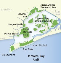
Maps for Jamaica Bay Unit

Jamaica Bay Unit

Within the Jamaica Bay Unit there are several places to visit. Floyd Bennett Field, Jamaica Bay Wildlife Refuge, Canarsie Pier, Breezy Point, Fort Tilden and Jacob Riis Park.
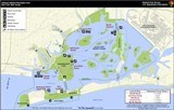
 
Jamaica Bay Kayaking Map

Jamaica Bay Kayak Map
This map shows the locations of places to launch kayaks or canoes into the bay. From there you are free to explore the salt marshes.
Please note: Landing on the marshes is not allowed.

 
Elders Point Restoration

Jamaica Bay Salt Marsh Change Map - 1951 to 2008
Using satellite imagery we map the marsh islands of Jamaica Bay to monitor their heath and how they change over time.

Last updated: September 2, 2020

Park footer

Contact Info

Mailing Address:

210 New York Avenue
Staten Island, NY 10305

Phone:

718 354-4606

Contact Us