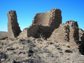
Tom Lyttle Trailhead: From the Visitor Center, go south on Highway 57 to an unmarked turn-off (3.8) miles south and west of the Visitor Center). Distance: 24 miles roundtrip from the Visitor Center. Elevation gain: 200 feet. The 2-track dirt road traverses gently rolling country with many hills and valleys. Time: 5 to 6 hours to ride the trail and visit the site. Note: Our most strenuous ride provides an all day ride to a distant Chacoan great house community beyond the canyon. Be prepared for your ride. This road leaves and reenters park lands. Please respect the private property of the park's neighbors. Permit: Not required, but check in at the Visitor Center for current information and directions. Kin Klizhin is a small Chacoan great house that lies about 7 miles southwest of PUeblo Bonito. Archaeologist believe that it was a civic and ceremonial center utilized by many surrounfing communities. Located on Kin Klizhin Wash, at an elevation of 6,520 feet, Kin Klizhin was connected to Chaco's center by a Chacoan road. The relationship between this "Chacoan outlier" and the core of Chaco Canyon is not well understood. Was this an independent community, or did the people suppor tand serve the people in the core of Chaco Canyon? Farming was an important aspect of the community, and the people may have provided food to the core area of Chaco Canyon. In the valley below the site, the community erected a large masonry and earthen dam on Kin Klizhin Wash to divert flowing waters into a canal and ditch system to water fields just downstream of the dam. This dam was modified in historic times and provided Navajo farmers with water for thier cornfields. 

Joseph Guy Kennedy |
Last updated: February 9, 2024
