Last updated: January 19, 2024
Article
Wild, Wacky, and Weird Weather. What the?

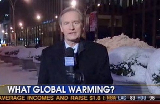
Recent Northeastern winters seem to be suffering from a severe case of schizophrenia. Bouncing back and forth from record cold and snowfall one day, to record warm temperatures and floods only a day or two later. What is one to make of this climatological conundrum? It is often during regional record cold or snow events that some news media run stories with photos of huge snow-banks with titles like "What Global Warming?" or "Northeast Prepares for Another 3 Feet of Global Warming." And the person who has just shoveled out form the third major blizzard in as many weeks may indeed be wondering how cold and snow can possibly relate to a warming climate.
Weather and Climate Defined
Before getting into finer detail, defining a couple of commonplace but key terms is critical to laying the groundwork for any discussion about global warming. The first and perhaps most important word is weather. Weather can be defined as the state of the atmosphere at a given time and place. It is very specific, local, and ephemeral - a snapshot in time, much like a photograph. This is in contrast to climate, which is made up of long-term weather patterns with average temperatures and precipitation totals (including the typical occurrences of weather extremes) that are used to characterize a particular region. Think of climate more like a documentary movie. It takes many thousands of weather 'photos' put together to see the climate ‘movie’ and to tell its story. Much in the same way that trying to use a single frame from a reel of an Alfred Hitchcock movie to figure out the whole story would be fruitless, so is using one isolated weather event in one very specific part of the world to try to understand global climate. The distinction is very important because it is often misplaced references to weather events that are used to either bolster or weaken supposed evidence of climate change. Recent weather events perfectly illustrate this point: at the specific time and place of Redding, California at 6:07 AM on February 21, 2018, records for cold were being set and their fruit and vegetable crops were damaged (a weather photo). In the east and southern two-thirds of the country, temperatures have been higher than normal this winter, and globally averaged temperature for 2017 show it was the third warmest year in NOAA’s 138-year climate record, not far behind the warmest year of 2016 and the second warmest of 2015 (climate movie).

National Climate Assessment Draft
Earth is Getting Warmer – Prepare for Big Snowstorms. Huh?
Climate scientists have been warning for decades now that a warming climate increases the odds for the Earth to experience more weather extremes including floods, droughts, hurricanes, and - perhaps a bit counter intuitively - record setting snowfall events in some parts of the world. Paradoxically, a warmer atmosphere can produce more snow than a very cold one. As human activity continues to warm the Earth and more moisture is absorbed into the atmosphere, we are steadily loading the dice in favor of more extreme storms in all seasons, including winter. Six of the 10 biggest recorded snow storms in Boston have occurred since 1997, and six of the ten snowiest winters on record there have occurred since 1993 (records began in 1872). Not coincidentally, all 10 of the warmest years globally have taken place since 1997. Recent big snowstorms in New England come as no surprise to scientists who study climate as many have stated that precipitation is likely to continue becoming more intense because of a warming climate, including winter storms.
The Warmer the Ocean - the Wetter the Atmosphere
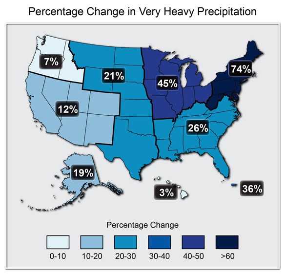
One key factor that can have a dramatic effect on winter weather is sea surface temperature. During the particularly snowy and cold winter of 2014-15, oceans waters off the coast of New England experienced an extreme warm anomaly with waters averaging about 2F warmer overall and as high as 21F warmer in some locations. The National Oceanic and Atmospheric Administration has stated that this follows a trend in which sea surface temperatures have been higher during the past three decades than at any other time since observations began in 1880. The laws of physics governing the atmosphere allow for warmer air to evaporate and hold more water vapor, meaning winter storms feeding off of warm seas can produce large amounts of snow. For most conditions at sea level, the atmosphere can hold 4% more moisture per 10F increase in temperature - which is why it makes sense that a record warm ocean off the east coast and record amounts of snow in Boston can happen simultaneously. The Nor’easters that pummeled much of New England that winter got their power from the contrast between cold land temperatures and warmer surrounding waters. A recent United Nations Intergovernmental Panel on Climate Change report warned that Nor’easters could grow stronger with climate change as this contrast becomes greater. The “Snowmageddon” event of February 2010 also took place during unusually high sea-surface temperatures in the Atlantic of about 30F above average that led to large amounts of moisture being fed into the circulation of the storm and resulting in heavy snow amounts in the Washington DC area. This fits into a trend for the Northeast that was highlighted in a recent U.S. National Climate Assessment report: during the period from 1958 to 2011, the region has seen a 71% increase in extreme precipitation. Summer and winter storms are not created by climate change, however they are made worse because of it.
Climate change is likely not only impacting what’s occurring in the Northeast, but also the natural disasters and extreme weather in other parts of the country. Long-term trends indicate that the dry areas are getting drier and the wet areas are getting wetter. The past couple of decades have shown more droughts in the Southwest and Southeast and more floods in the Midwest and Northeast. As for the future, a warming climate may also lead to bigger snow events possibly for decades to come - albeit within a much shorter winter season and lots of variability between storms for the Northeast. Today’s 15 or 20 degree snowstorm in a couple of decades could be a 25 or 30 degree snowstorm - as long as it remains cold enough large snow events are likely to continue for some time.

Accuweather
Lazy Jet Stream can lead to Weather Extreme
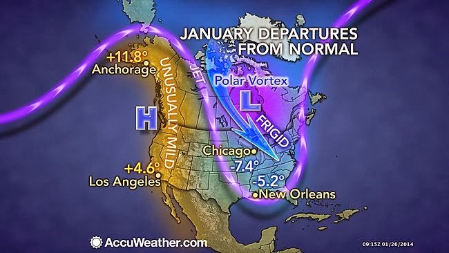
Prolonged cold snaps in the Northeast in recent years, warm Western winters, California’s drought, and freezing temperatures in the South all have one thing in common. They are being greatly influenced by the exaggerated meandering behavior of the atmospheric jet stream - the high-altitude, high-speed wind that blows around Earth at mid and polar latitudes and transports weather systems across North America. In recent years, huge, slow-moving swings in the jet stream have resulted in “blocking patterns” with a large dome of high pressure that can sit for a week or more and lead to historic heat waves in one part of the country, and record cold in another. In the U.S., more than 14,000 warm-weather records (record-warm daytime highs and record-warm overnight lows) were set or tied during March of 2015 during one of these events, as compared to about 700 cold records: a 20-to-1 ratio.
The strength and location of the jet stream depends on the temperature gradient between the regions of cold and warm air – the greater the difference, the faster, straighter, and stronger the jet stream. This makes some sense to anyone who has ever cracked open the window of a 70 degree house to a world outside that is 10 below zero – there is a noticeable rush of air whooshing past you because of the large temperature gradient. Likewise, opening the window of a 70 degree house to an 80 degree summer’s day results in little flow. There are an increasing number of scientists who believe warmer temperatures in the Arctic are causing more amplitude, or bigger waves, in the jet stream. Since the 1990’s it has been varying more wildly and more often. Deep dips, or troughs, fill with frigid Arctic air and the places where it stays high in the Arctic (ridges) allows for warm air to settle in below it. Ridges and troughs are a normal part of jet stream activity, the unusual part is that they are lingering in the same place for months on end and have been more persistent in both magnitude, their projection to the south, and location - dipping further south and in the same areas. This reduced temperature gradient between northern and southern areas is causing the westerly component of upper-level winds to slow, especially during the fall when extra heating in the Arctic is at its strongest. These westerly fall winds have weakened by about 14% since 1979. Weaker westerly winds cause the big north/south swings in the jet stream to move more slowly from west to east, making weather conditions in a given location more persistent than they used to be. Instead of swirling around the world, winds more often reverberate back-and-forth in the same place.
Climate researchers at Rutgers and Wisconsin universities recently published a study that linked the ultra-wavy north/south jet stream pattern to rapid warming in the Arctic. Climate is warming faster there than at Earth’s middle latitudes due to a combination of human greenhouse gas emissions and unique feedbacks built into the Arctic climate system. Study authors predict this will lead to more extreme weather across the country - possibly for decades to come. The study notes that between 1995 and 2013 – the period when the Arctic began warming disproportionately fast – exaggerated waves over North America became 49% more common during the North American summer and 41% more common in the autumn than they were between 1979 and 1994, before the relatively faster Arctic warming began.
The study also warns that future weather patterns, given projections showing that Arctic climate change is likely to accelerate in coming years, will likely increasingly be influenced by Arctic warming far beyond the North Pole for many years to come. In other words - buckle down Northeast. This winter may be one in a long series that packs some serious Nor’easter power and wild temperature swings.
Tags
- acadia national park
- appalachian national scenic trail
- boston harbor islands national recreation area
- eleanor roosevelt national historic site
- home of franklin d roosevelt national historic site
- marsh - billings - rockefeller national historical park
- minute man national historical park
- morristown national historical park
- saint-gaudens national historical park
- saratoga national historical park
- saugus iron works national historic site
- vanderbilt mansion national historic site
- weir farm national historical park
- species spotlight
- netn
- climate change
- global warming
- global warming/climate change
- weather
- winter
