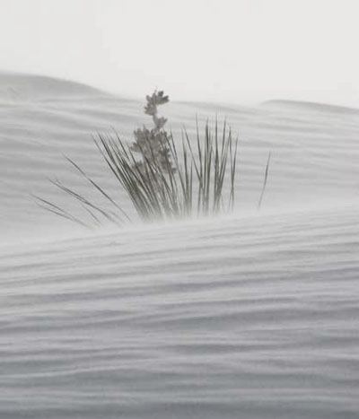
The Chihuahuan Desert is one of the most intense source areas of dust storms in the Western Hemisphere; and because white gypsum dust is often visible on weather satellite images on dry, windy days, the White Sands are one of the most notable sources of dust in the Chihuahuan Desert.
Introduction
NPS
Their geographical position in the northern part of the desert places the White Sands in the path of weather systems crossing the United States, but far enough south that these storms produce wind without moisture. Thus, the White Sands are arguably one of the most intense and frequent source areas of blowing dust in North America. Especially in the dry, windy season (roughly between October and May), aerosols (airborne particles) are frequently emitted from the White Sands on westerly winds and “ramped up” into the atmosphere over the Sacramento Mountains, so that they may be transported very long distances downwind, across New Mexico, occasionally into Texas, and perhaps beyond.
Throughout the world, dry lake beds ringed by sand dunes (like at White Sands National Monument) are the prime source areas of dust. The White Sands possess the key features of a dust “hotspot”—dry desert environment; strong winds; loose, fine sediments; and little vegetation. As compared to most desert dust, which is comprised primarily of silicate minerals, the calcium sulfate (gypsum) dust from White Sands could behave differently, as it is transported through and interacts with the atmosphere, and have important effects on the environments where it is deposited downwind.
Methods
Weather data from meteorological stations at Alamogordo and Holloman Air Force Base were used to identify dusty days (low humidity and visibility, strong winds). The National Oceanic and Atmospheric Administration (NOAA) Geostationary Operational Environmental Satellites (GOES) and NASA Moderate Resolution Imaging Spectroradiometer (MODIS) satellite images for those dates were searched and analyzed to identify dust clouds and pinpoint their source areas. Soil surveys and geological maps from throughout the region, in conjunction with remote sensing imagery and field work, were used to create a new map of the Chihuahuan Desert delineating the landforms most likely to be dust sources, with the actual origination points of dust sources overlaid onto the map. Aerosol samples were collected in a special study on the dry gypsum lake bed upwind of White Sands National Monument, and are regularly collected (as part of the national Interagency Monitoring of Protected Visual Environments (IMPROVE) air monitoring network) in the Sacramento Mountains of Lincoln County downwind of the White Sands. The samples were analyzed for chemical composition.
|
Objectives Objective 1 - To quantify the number and frequency of dust storms originating from the White Sands. Objective 2 - To pinpoint the dust sources and map the dust-producing landforms of the Chihuahuan Desert, and understand how the White Sands as a dust source fit into that picture. Objective 3 - To determine the size and chemical composition of aerosols (dust particles) emitted from the White Sands and transported downwind. |
Results
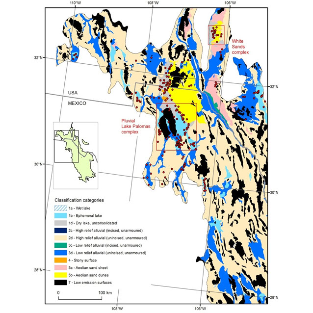
From M. C. Baddock, T. E. Gill, J. E. Bullard, M. Dominguez Acosta, and N. I. Rivera Rivera. 2011. Geomorphology of the Chihuahuan Desert based on potential dust emissions. Journal of Maps 7: 249-259
About 10% of Chihuahuan Desert dust plumes, at a minimum, originate from the small area of the White Sands (Figure 1). Satellite images (Figure 2) clearly show the white dust travelling over the mountains and long distances downwind.
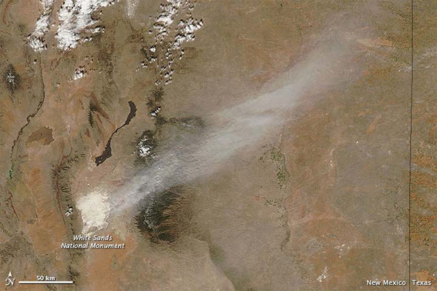
NASA
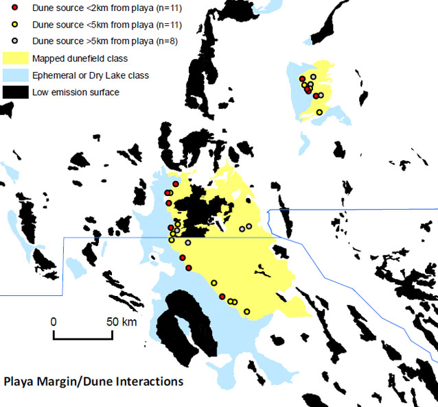
The White Sands represent one of the two main zones in the Chihuahuan Desert where playas (dry or ephemeral lakes) are adjacent to sand dunes, the ideal environment for a “hotspot” of desert dust emission (Figure 3). Playas and dunes cover only about 7% of the Chihuahuan Desert, yet represent over 60% of the dust sources.
The aerosols emitted from the White Sands during wind storms are very small, as tiny as 1 micron in size (Figure 4), thus able to travel very long distances: and composed of the same material as the sands and dry lake beds themselves (Figure 5).
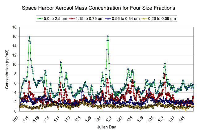
From C. F. Cahill and others. 2005. Springtime dust aerosols at White Sands Missile Range, NM. Presentation #P22B-02, American Geophysical Union 2005 Fall Meeting.
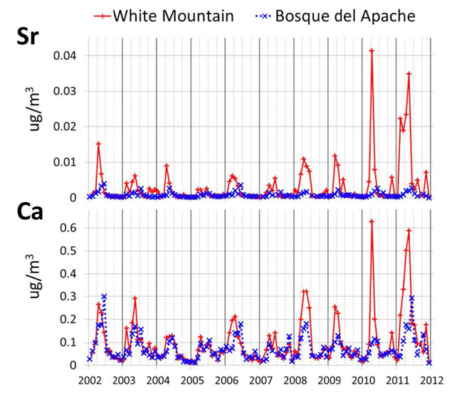
After W. H. White, K. Trzepla and T. Gill, 2013. Gypsum Aerosol Downwind of White Sands, NM. Presented at the NOAA Earth System Research Laboratory Global Monitoring Conference.
Discussion and Implications
This research clearly confirms the importance of the White Sands as a “hot spot” of dust storms. These dust storms are a natural geological process caused by a unique combination of the geology, geography, climate, and ecology of the White Sands and Tularosa Basin, and have probably been happening ever since the climate dried after the last Ice Age, and will continue long into the future.
The researchers plan to continue this work to better quantify the relationship of dust emissions from the White Sands to specific wind conditions, drought-water cycles, and other weather and climate patterns. The goal is to make estimates of the actual amount of dust that is blown out of the White Sands, as well as improve our understanding of the characteristics of the dust to better predict its impact. Because the chemical composition of aerosols emitted from the White Sands is different from that of typical desert dust, its environmental impact on the ecosystems downwind where it is deposited and on persons who may breathe it is unknown; more research is needed to understand these potential effects.
Contact
For more information, contact:
Thomas E. Gill, tegill@utep.edu
Department of Geological Sciences
University of Texas-El Paso
Collaborators
Thomas E. Gill
Department of Geological Sciences, University of Texas-El Paso
Miguel Dominguez Acosta
Departamento de Ingeniería Civil, Universidad Autónoma de Ciudad Juárez, Mexico
Matthew C. Baddock
Atmospheric Environment Research Centre, Griffith University, Brisbane, Australia
Catherine F. Cahill
Geophysical Institute, University of Alaska-Fairbanks
Warren H. White
Crocker Nuclear Laboratory, University of California-Davis
Prepared in collaboration with the National Park Service, 2013.
Last updated: November 30, 2016
