Last updated: May 5, 2023
Article
Vieux Carré: A Creole Neighborhood in New Orleans (Teaching with Historic Places)
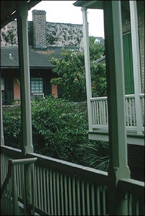
This lesson is part of the National Park Service’s Teaching with Historic Places (TwHP) program.
Hugging the bank of the huge, swiftly moving Mississippi River and lying barely above sea level is the Vieux Carré [view-ka-ray], or French Quarter, in New Orleans, Louisiana. Buildings crowd each other and the narrow streets. Cast-iron and wrought-iron balconies overhang the sidewalks, providing shelter from hot summer sun or sudden downpours. Cool, inviting courtyards can be glimpsed down narrow alleys or carriageways, and the smells of shrimp remoulades and seafood gumbos waft from hidden kitchens. Cathedral bells, jazz trumpets, and ship horns serenade residents and visitors. The Quarter is the heart and soul of modern New Orleans and serves as a continuous reminder of the city’s Creole, colonial past.
About This Lesson
This lesson is based on the National Register of Historic Places registration file, "Vieux Carré Historic District" (with photographs) and other source materials about the Vieux Carré. It was written by Byron Fortier, a former Park Ranger at Jean Lafitte National Historical Park and Preserve. It was edited by Fay Metcalf and the Teaching with Historic Places staff. TwHP is sponsored, in part, by the Cultural Resources Training Initiative and Parks as Classrooms programs of the National Park Service. This lesson is one in a series that brings the important stories of historic places into the classrooms across the country.
Where it fits into the curriculum
Topics: This lesson could be used in teaching units on colonial history, westward expansion in 18th- and 19th-century America, or multiculturalism.
Time period: Colonial to 19th-century America
United States History Standards for Grades 5-12
The Vieux Carré: A Creole Neighborhood in New Orleans relates to the following National Standards for History:
Era 2: Colonization and Settlement (1585 to 1763)
-
Standard 1A- The student understands how diverse immigrants affected the formation of European colonies.
-
Standard 1B- The student understands the European struggle for control of North America.Era 4: Expansion and Reform (1801 to 1861)
-
Standard 1A- The student understands the international background and consequences of the Louisiana Purchase, the War of 1812, and the Monroe Doctrine.
Curriculum Standards for Social Studies
(National Council for the Social Studies)
The Vieux Carre': A Creole Neighborhood in New Orleans relates to the following Social Studies Standards:
Standard A - The student compares similarities and differences in the ways groups, societies, and cultures meet human needs and concerns.
Standard B - The student explains how information and experiences may be interpreted by people from diverse cultural perspectives and frames of reference.
Standard C - The student explains and gives examples of how language, literature, the arts, architecture, other artifacts, traditions, beliefs, values, and behaviors contribute to the development and transmission of culture.
Standard E - The student articulates the implications of cultural diversity, as well as cohesion, within and across groups.
Theme II: Time, Continuity and Change
Standard B - The student identifies and uses key concepts such as chronology, causality, change, conflict, and complexity to explain, analyze, and show connections among patterns of historical change and continuity.
Standard C - The student identifies and describes selected historical periods and patterns of change within and across cultures, such as the rise of civilizations, the development of transportation systems, the growth and breakdown of colonial systems, and others.
Theme III: People, Places, and Environment
Standard A - The student elaborates mental maps of locales, regions, and the world that demonstrate understanding of relative location, direction, size, and shape.
Standard B - The student creates, interprets, uses, and distinguishes various representations of the earth, such as maps, globes, and photographs.
Standard E - The student locates and describes varying landforms and geographic features, such as mountains, plateaus, islands, rain forests, deserts, and oceans, and explain their relationships within the ecosystem.
Standard F - The student describes physical system changes such as seasons, climate and weather, and the water cycle and identify geographic patterns associated with them.
Standard G - The student describes how people create places that reflect cultural values and ideals as they build neighborhoods, parks, shopping centers, and the like.
Standard H - The student examines, interprets, and analyzes physical and cultural patterns and their interactions, such as land use, settlement patterns, cultural transmission of customs and ideas, and ecosystem changes.
Standard I - The student describes ways that historical events have been influenced by, and have influenced, physical and human geographic factors in local, regional, national, and global settings.
Theme IX: Global Connections
Standard A - The student describes instances in which language, art, music, belief systems, and other cultural elements can facilitate global understanding or cause misunderstanding.
Standard D - The student explores the causes, consequences, and possible solutions to persistent, contemporary, and emerging global issues, such as health, security, resource allocation, economic development, and environmental quality.
Standard E - The student describes and explains the relationships and tensions between national sovereignty and global interests in such matters as territory, natural resources, trade, use of technology, and welfare of people.
Objectives for students
1) To describe the boundaries of colonial Louisiana and list the succession of colonial governments that controlled the area.
2) To explain the political and strategic significance of New Orleans in colonial and American history.
3) To describe the origins and evolution of Creole culture in South Louisiana.
4) To explain how European concepts of style were modified to fit local conditions, producing a distinctive architectural legacy, and how those styles changed as the area became increasingly "Americanized" physically and culturally.
5) To identify physical evidence of various cultural influences in their own community.
Materials for students
The materials listed below either can be used directly on the computer or can be printed out, photocopied, and distributed to students. The maps and images appear twice: in a low-resolution version with associated questions and alone in a larger, high-quality version.
1) five maps of the French and Spanish claims in North American, the Louisiana Purchase, the Mississippi Delta, and New Orleans;
2) two readings about the history of New Orleans and its Creole culture;
3) seven photos of the area, including street scenes and historic structures;
4) three drawings of a typical Vieux Carré townhouse architecture.
Visiting the site
The Vieux Carré is located in downtown New Orleans, roughly bounded by Canal Street, Rampart Street, Esplanade Avenue and the Mississippi River. A French Quarter Visitor Center, operated by Jean Lafitte National Historical Park and Preserve, is located at 419 Decatur Street in New Orleans. For more information, contact the park at 504-589-3882 or visit the park's Web page.
Getting Started
Inquiry Question
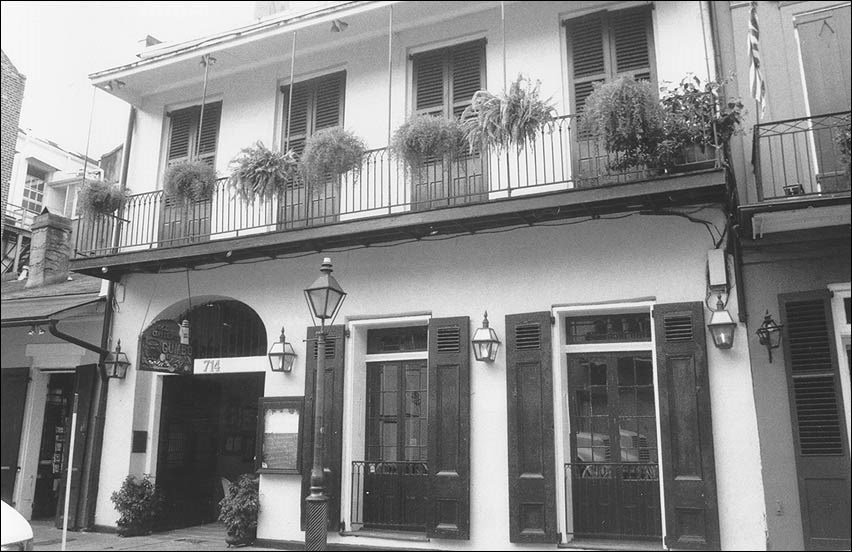
Where might this building be?
Setting the Stage
While the English were developing the original 13 colonies along the East Coast, other European nations were active in North America. The French and the Spanish, in particular, were pursuing their colonial aims in areas farther inland and along the Gulf Coast. One result was that as Americans from the eastern states later moved across the continent, they encountered not only American Indian societies, but other European American communities as well.
In the years before the Louisiana Purchase of 1803, those who lived in Louisiana Territory were known as Creoles. These settlers had developed a distinctive culture from many diverse influences. The Vieux Carré ("old square") is the original city of New Orleans as laid out by the French military. Today, the Vieux Carré contains a remarkably well-preserved collection of buildings covering a wide range of styles and periods in an approximately 120-block area. It preserves the architectural legacy of the city’s Creole past, while revealing that American influences proved irresistible and had noticeable impact on the district’s styles and forms.
Locating the Site
Map 1a: The French claim to North America, 1754.
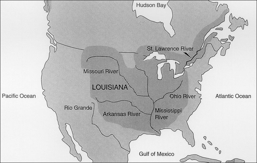
Map 1b: Spanish claims, 1763.
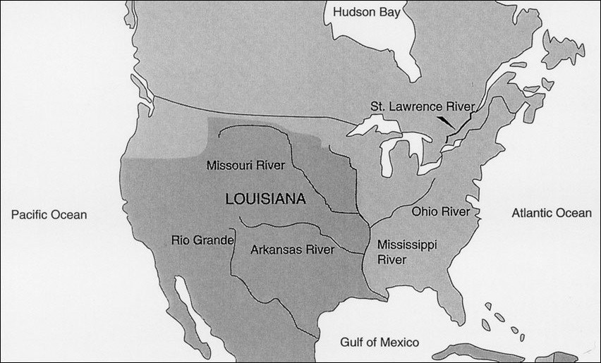
Map 1c: The Louisiana Purchase, 1803.
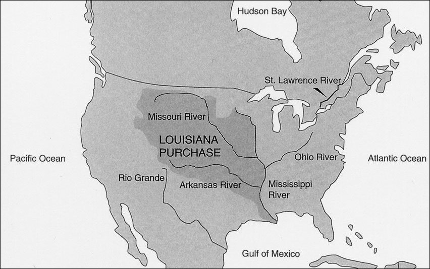
Questions for Maps 1a, 1b, & 1c
*Refer to a modern map of the United States while answering the following questions.
1. How many states appear to be in the area of the original French claim?
2. Is your community in the Mississippi Valley? along one of the other rivers in the French claim? in Spanish Louisiana? in the area of the Louisiana Purchase?
3. Is there a difference in the size and area of Spanish Louisiana and the Louisiana Purchase? Why?
Locating the Site
Map 2: The Mississippi Delta, 1720.
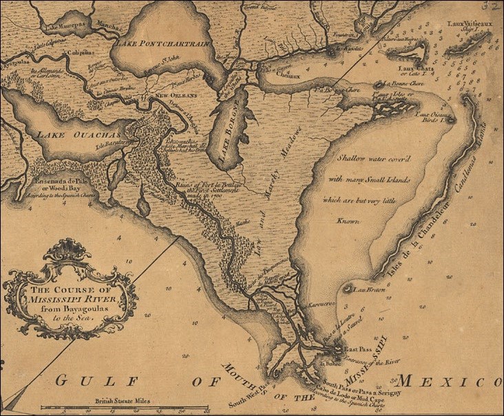
Questions for Map 2
1. Locate Lake Pontchartrain, Bayou St. John, the lower Mississippi River, the Gulf of Mexico, and New Orleans.
2. If you wanted to control traffic and trade on the Mississippi River, where would you locate a city? Why?
3. Would there be advantages in locating a city closer to the mouth of the river? What are some possible problems with that location?
4. What are some possible advantages of the site that was selected for New Orleans?
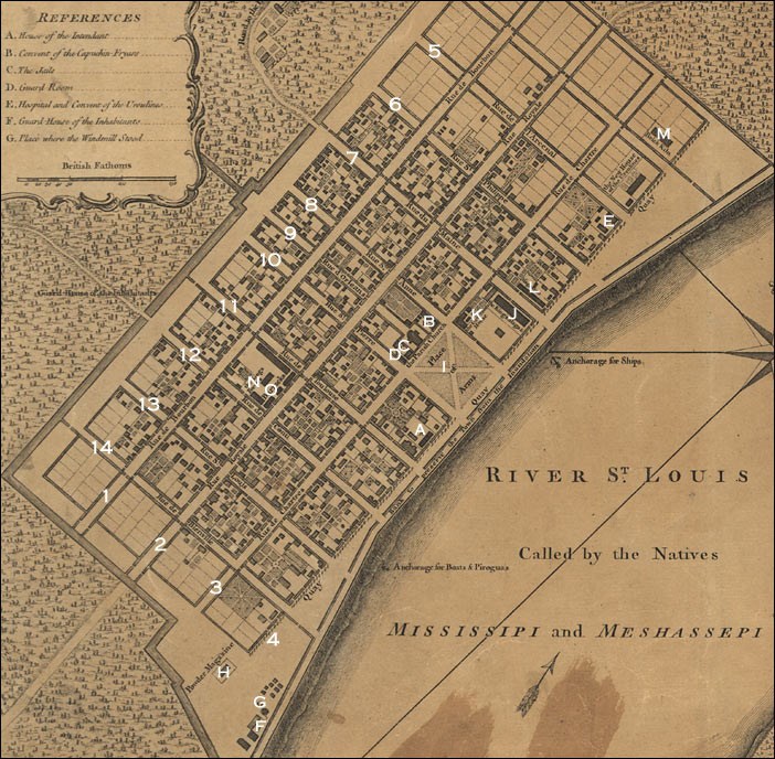
Library of Congress.
| Map Key: A. House of Intendant B. Convent of the Capuchin Fryars C. The Jails D. Guard Room E. Hospital and Convent of the Ursulines F. Guard House of the Inhabitants G. Place where the Windmill Stood H. Powder Magazine I. Place of Arms J. The King's Magazine K. The Governor's House L. Magazine M. Brick Kiln N. The Kings Forges O. Barracks |
Street Key: 1. Rue de Bourbon 2. Rue Royale 3. Rue de Chartres 4. Quay 5. Rue de l'Arcenal 6. Rue St. Philippe 7. Rue du Maine 8. Rue Ste. Anne 9. Rue d'Orleans 10. Rue St. Pierre 11. Rue de Toulouse 12. Rue de Conti 13. Rue St. Louis 14. Rue de Bienville |
Questions for Map 3
1. Locate the open square near the river. What activities might it have been used for?
2. What natural features surround the Vieux Carré? If needed, see Map 2.
3. What effect might the wet conditions have on the way the Vieux Carré developed?
4. This plan does not show the forts established to protect the city, but it does indicate the military presence. Locate the military structures.
5. What evidence can you find that demonstrates the French influence in Vieux Carré?
Determining the Facts
Reading 1: The History of Settlement in Louisiana
In 1682 the French explorer La Salle journeyed down the Mississippi River to its mouth and claimed for France all the lands drained by the river and its tributaries. The area was named Louisiana in honor of King Louis XIV, the reigning French monarch. Later, the French began extensive explorations of lower Louisiana with the aim of establishing a permanent settlement.
As the Mississippi River nears the Gulf of Mexico, it curves and bends through the flat, marshy land of Louisiana’s Delta Region. Outside one of these turns the French chose in 1718 to establish their new city. Despite its precarious location, surrounded by swamps and subject to flooding and storms, New Orleans was the gatekeeper to the vast Mississippi Valley. From this location the French hoped to secure control of the river and any traffic on it.
In 1722 the French military engineer, Adrien de Pauger, laid out the streets of the city in a grid pattern, forming what is now known as the Vieux Carré, or French Quarter. Settlers were recruited from France, African slaves were brought into the colony early on, and even a contingent of German settlers migrated into the area during French rule. Growth of the city was slow, but de Pauger’s grid gradually filled in.
In 1762 as a result of the French and Indian War (known in Europe as the Seven Years’ War), Louisiana was divided and New Orleans came under Spanish control. Under the Spanish, growth and prosperity increased as the city’s promise as a great world port came to be realized. During this period, 1788 to 1794, two great fires swept the city, and the rebuilding reflected some Spanish influence. Spanish immigration into Louisiana was limited, however, so the French cultural presence remained strong.
In 1800 the French under Napoleon reacquired New Orleans by secret treaty. The Americans eventually learned of the treaty and were alarmed that Napoleon was now in control of the Mississippi River. It had become critical to American interests in the West that they be able to move goods on the river and through the port at New Orleans. President Thomas Jefferson instituted negotiations with the French to purchase New Orleans, which led to the acquisition of the entire territory in the Louisiana Purchase of 1803. With the Louisiana Purchase, the colonial period of New Orleans history came to a close. The city became a focus of the general westward expansion of Americans in the 19th century, but it was far different from any other settlement they encountered in their westward movement.
Questions for Reading 1
1. Why were the French interested in establishing control of the land drained by the Mississippi River and its tributaries?
2. Who were the early settlers in New Orleans?
3. How long did Spain have control of the region?
4. Why was the Louisiana Purchase a good buy for Americans?
Reading 1 was adapted from Tom Ireland, Vieux Carré Ethnographic Overview, National Park Service, Jean Lafitte National Historical Park and Preserve, 1978.
Visual Evidence
Photo 1: Vieux Carré street scene.
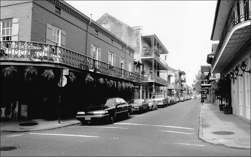
Photo 2: Vieux Carré street scene.
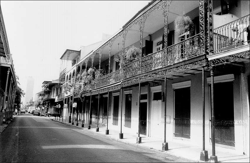
Photo 3: Aerial view of a typical block in the Vieux Carré.
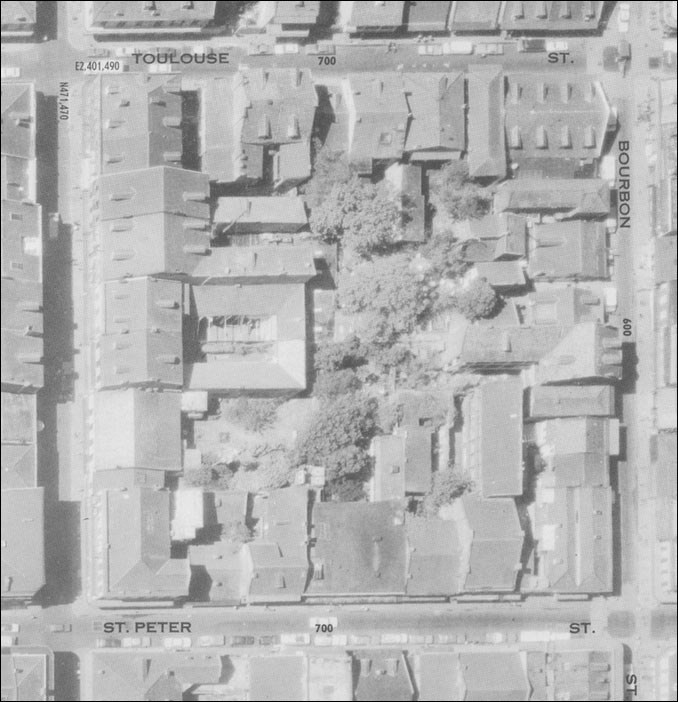
Questions for Photos 1-3
1. Compare Photos 1 and 2. What are your impressions of the two street scenes? What adjectives would you use to describe them? What characteristics give you clues about Vieux Carré's surrounding natural environment? Refer to Map 3 if needed.
2. Examine Photo 3. What characteristic is particularly noteworthy when describing this scene?
3. Note in Photo 3 that the interior of each block is a honeycomb of private spaces. Why might these courtyards have been located where they are? What are the possible advantages of having outdoor space in the form of courtyards?
4. Compare and contrast these scenes to your own community. How are they different? In what ways are they alike? Would you like to live in this type of environment? Why or why not?
Visual Evidence
Photo 4: Dependency structures and outbuildings.
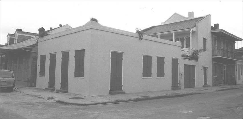
Questions for Photo 4
1. How do you think these outbuildings might have been used?
2. Creole families often had separate "garconierres" [gar-sone-yairs], rooms where the older sons of the family lived. They were located in outbuildings of this type and allowed the boys to come and go without disturbing the rest of the family. What do you think about this custom?
3. Girls had no separate living space and were closely chaperoned. What does this tell you about the role of boys and girls during this time? What does it tell you about Creole culture?
Visual Evidence
Photo 5: Facade of a Creole townhouse.
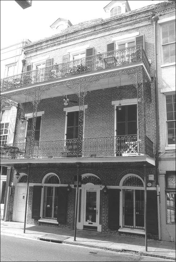
Photo 5:
The Creole townhouse was the most common of housing units when the city was rebuilt after the fires of 1788 and 1794. They were rectangular, two to four stories high with wrought iron balconies. The passageway to the courtyard was large enough for one person to walk through. Most Creole townhouses had pitched roofs and roof dormer windows.
Photo 6: Facade of a Porte-Cochere Creole townhouse.

Photo 6:
The Porte-Cochere Creole townhouse, whose name means "coach door," was common from about 1800 to 1850. These two- to four-story houses had a carriageway entrance leading to a rear courtyard. The ground floor was generally used as a shop, while the upper floor/floors were used as living space.
Photo 7: Facade of an American (Greek Revival) townhouse.
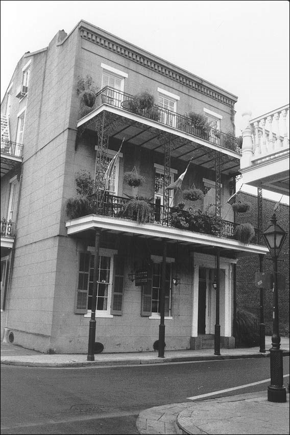
Photo 7:
The American townhouse features an interior stairway while Creole townhouses have passageways and stairways on the exterior of the house.
Questions for Photos 5-7
1. Examine Photos 5-7 and read the descriptive matter. Make a list of the architectural features that are similar in the three townhouses. Make a list of the differences. Would you assume that these buildings are in the same neighborhood? Why or why not?
2. Based on what you learned in the readings, what culture had the greatest influence on the architectural styles of these buildings? What other factors had an influence on the design of the townhouses?
3. Locate a townhouse in your community or research townhouses in an area where they are prevalent such as the east coast. Make sketches or take photographs based on your findings and compare them with the types found in New Orleans.
Visual Evidence
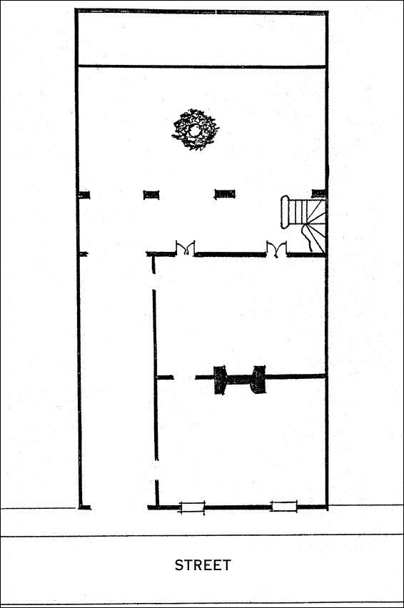
Drawing 1: Typical floor plan of a Creole townhouse.
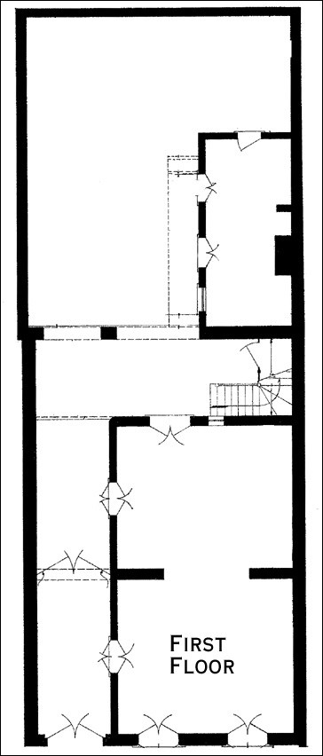
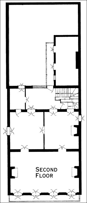
Drawings 2a & 2b: Typical floor plan of a Porte-Cochere Creole townhouse.
(Historic American Buildings Survey Collection--Library of Congress)
Questions for Drawings 1, 2a, & 2b
1. Locate the photographs from Photos 5-7 that show a Creole townhouse facade and a Porte-Cochere [port-ko-share] Creole townhouse facade. Then examine Drawings 1, 2a, & 2b to get an idea of what the homes are like inside. What is the most unusual or interesting feature of each house?
2. Label the rooms shown in each sketch as you would use them if you lived there. Keep in mind that there was no indoor plumbing at the time these houses were built and most houses had privies located at the rear of courtyards.
3. List the differences between the two townhouses. What are the advantages or disadvantages for each type of house?
4. What are the rooms at the back of the house called? What purpose do they serve? If needed, see Photo 4.
5. Examine Photo 7 and read the descriptive matter. How might the floor plan for the American townhouse differ from the two Creole townhouses? Draw a floor plan for the American townhouse based on your thoughts.
Putting It All Together
The following activities will help students research the American tradition of cultural diversity and investigate its impact on the state of Louisiana as well as their own community.
Activity 1: Architectural Change
Read the following passage to students:
The noted American architect Benjamin Henry Latrobe (architect of the U.S. Capitol) took up residence in New Orleans in 1819. When he arrived he was greatly impressed by the Creole character of the city, but noted regretfully the beginnings of an American influence: ‘The merchants from the old United States who are daily gaining ground on the manners, the habits, the opinions, and the domestic arrangements of the French, have already begun to introduce the lop-sided London house.’ Latrobe predicted: ‘In a few years, therefore, this will be an American town. What is good and bad in French manners...must give way, and the American notions of right and wrong, of convenience and inconvenience will take their place.’¹
Now have students look again at Photos 5 and 7. Ask them to review their list of differences in the two buildings. (The prominent features of the building in Photo 5 are the three-bay, three-arched openings on the first floor, multi-light french doors and fanlight transoms. The fourth door--on the left in the picture--is not typical. The building in Photo 7 shows the American influence, primarily in the Greek Revival detailing. Point out features such as the denticulated cornice and the recessed doorway with an entablature and wooden Doric pilasters. If the students are familiar with Greek Revival styles, they may wonder where the columns are. Explain that the Vieux Carré’s tight block pattern did not allow space for them.)
Ask the students if after viewing all the photographs, they think that Latrobe’s statement has come true. Does the Vieux Carré look "American"? Does it look like their home town? While American influences are evident, much of the Creole influence has survived, and the Vieux Carré has a balanced character. Ask students to suggest and discuss some reasons for the persistence of the Creole "look" of the Vieux Carré. (One reason was that when American stylistic influences began to be strongly felt in the 1830s, the area already had developed a tight block pattern, with deep and narrow lots oriented to rear courtyards. This existing development pattern helped determine the character of American development in the district. For instance, the wide central hall house, an American favorite, was almost unknown in the district. Likewise, the American practice of setting a house back from the street, to provide for a front yard, was rarely seen in the Vieux Carré. Buildings tended to conform to the streetscape already set by the Creole cottages and townhouses. Americans also continued the tradition of using cast-iron balconies and galleries to embellish their houses’ facades.)
Activity 2: Researching Creole Culture
Other aspects of Creole culture continue to be strongly felt in New Orleans and South Louisiana. Ask the students to research such topics as Creole cuisine (the cuisine of most of New Orleans’ famous restaurants), Mardi Gras, or jazz music. Another subject that students could research is Acadian, or Cajun, culture in south Louisiana. Acadians are descendants of the French who migrated to Acadia, now Nova Scotia, Canada, in the early 1600s. Beginning in 1755, many were expelled from that area by the British, and some migrated into Louisiana in the next two or three decades. Their descendants in Louisiana today are often known as Cajuns (a corruption of "Acadian"), and live principally in rural areas of South Louisiana. Cajuns have retained many traditional aspects of their culture. Those not familiar with the region often confuse the terms "Cajun" and "Creole." Daily Life in Louisiana, 1815-1830, by Liliane Crete, as translated by Patrick Gregory (Baton Rouge, La.: Louisiana State University Press, 1978) can provide more information on Creole culture. Background on Cajun life and culture can be found in two pamphlets published by the Center for Louisiana Studies at the University of Southwestern Louisiana: Carl Brasseaux, Scattered to the Winds: The Dispersal and Wanderings of the Acadians, 1755-1809 (Lafayette, La.: Center for Louisiana Studies, University of Southwestern Louisiana, 1991) and Barry Ancelet, Cajun Music: Its Origins and Development (Lafayette, La.: Center for Louisiana Studies, University of Southwestern Louisiana, 1989). Both of these pamphlets can be purchased from the Center for Louisiana Studies by contacting them at P.O. Box 40831, Lafayette, LA 70504.
Activity 3: The Local Community
Ask the students to examine their local community for evidence of diverse cultural groups. Are there buildings, customs, foods, etc., that can be identified with particular ethnic groups? Are those groups still living in the area today? Do they have a distinct identity today or have they blended into the larger population? Public libraries usually have local histories and copies of neighborhood surveys that will help guide the research. If you can take students on a walking tour of a nearby ethnic neighborhood or commercial area, arm them with sketch pads and cameras and have them record architectural details on houses, row or townhouses, apartment buildings, and commercial buildings. Ask them to look for evidence that indicates particular ethnic groups live or work there, now or in the past. Back in the classroom, have students point out differences between their local surroundings and the Vieux Carré.
Activity 4: Cultural Interaction
Ask students to consider what happens when two different cultural groups live side by side. What aspects of the neighboring culture is each group most likely to adopt, or at least try out (food, music, clothing styles)? What aspects of the neighboring culture are most likely to be resisted or rejected (religion is likely)? In what circumstances would one group feel culturally threatened by another (if one is much larger numerically, or has more political or economic power)? Ask students to think about the history of their community and write short papers describing the quality of ethnic relationships, both now and in the past. Discuss essays in class. If there is or has been considerable dissension among groups, have the students develop an action plan to alleviate tensions.
¹Division of Historic Preservation, State of Louisiana. "Vieux Carré Historic District" (Orleans Parish, LA) National Register of Historic Places Registration Form. Washington, D.C.: U.S. Department of the Interior, National Park Service,1984, Section 8, p.1.
The Vieux Carré: A Creole Neighborhood in New Orleans--
Supplementary Resources
By looking at The Vieux Carré: A Creole Neighborhood in New Orleans, students examine New Orleans's distinctive French Quarter, a vibrant reflection of its Creole heritage, and recall the city's role in American westward expansion. Those interested in learning more will find that the Internet offers a variety of interesting materials.
Jean Lafitte National Historic Park & Preserve
Vieux Carré and the French Quarter Visitor Center are part of Jean Lafitte National Historic Park & Preserve, which is a unit of the National Park System. Jean Lafitte National Historical Park and Preserve was established to preserve significant examples of the rich natural and cultural resources of Louisiana's Mississippi Delta region. Visit the park's web pages to learn more about the park's history and visiting the site.
Library of Congress
Search the American Memory Collection for resources on Vieux Carré, New Orleans, and Louisiana. Most interesting is the Historic American Buildings Survey/Historic American Engineering Record's (HABS/HAER) documentation on Vieux Carré. There are drawings, photos, and pages of documentation in this collection. Please see the HABS/HAER documentation on the Valery Nichols House to learn more about the Port-Corchere floor plans used in Drawings 2a & 2b.
National Archives and Records Administration
The National Archives and Records Administration on-line exhibit, American Originals, features the three separate agreements between the United States and France known as The Louisiana Purchase. The Louisiana Purchase nearly doubled the size of the United States, making it one of the largest nations in the world.
African American History
Academic Info: African American History is an annotated directory of Internet resources on black history and culture. Each subject guide is a listing of general Internet sites in the field, as well as a gateway to more advanced research tools. Sources vary from online publications, language and study aids, and reference materials, to databases, archives, virtual libraries, and tutorials.
Boston College: A Digital Archive of American Architecture
This digital archive consists of nearly 1,500 digitized images of different styles of American architecture (280 buildings) plus explanatory material.
Tags
- louisiana
- louisiana history
- new orleans
- architectural history
- louisiana purchase
- teaching with historic places
- twhp
- national register of historic places
- nrhp listing
- african american history
- latino history
- colonial
- migration and immigration
- latino heritage
- music
- jazz
- american latino heritage
- american latino
- french settlement
- french quarter
- twhplp
- ea aah
