Last updated: February 14, 2019
Article
The Vanishing Santa Cruz River

Background
The Santa Cruz River flows through Tumacácori National Historical Park (NHP) on its way north after curving south into Mexico not far from its headwaters in the U.S. In the past, the Santa Cruz was sometimes known as “the lessening stream,” as its flow has historically varied widely with changes in natural conditions and human use. Since 1951, however, the Santa Cruz has been bolstered by a steady flow of treated effluent from the Nogales International Wastewater Treatment Plant (NIWTP), located 10 miles upstream of the park. As a result, the river supports a rare southwest cottonwood–willow riparian environment, one of the most endangered ecosystems in the U.S., as it flows through the park.

The Issue
Recent changes to the river’s effluent inputs have reduced its flow; in fact, at Tumacácori NHP, the Santa Cruz stopped flowing in mid-April 2013 and remained dry into August. A no-flow period of this length has not previously occurred during the record for the stream gage; it marks a change in system hydrodynamics and ecology. The current lack of flow in the river eliminates localized habitat for many aquatic taxa, including native fish, such as longfin dace (Agosia chrysogaster), and benthic macroinvertebrates, such as dragonfly (Odonata) larvae.
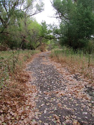
The reduction of water levels in the river and its adjoining soils has put stress on riparian trees and plants. The cottonwood–willow forest managed by Tumacácori NHP represents one of the last vestiges of this plant association in the western U.S. In order to thrive, the dominant trees of the park’s riparian gallery forest, Fremont cottonwoods (Populus fremontii), need groundwater to remain at a level around 2 meters below the surface (Stromberg et al. 1996). If groundwater falls below the roots of the cottonwoods and other vegetation, then the plants begin to get stressed and, in response, drop their leaves to conserve water (Figure 1). If the plants continue to have limited access to groundwater, extensive vegetation mortality can result.

Why is this Occurring?
The Santa Cruz River is an effluent-driven system, with most of its surface water provided by the NIWTP, in Arizona. In 1951, the plant discharged around 1.6 million gallons/day (mgd). Over the decades, that amount increased steadily as the international population it serves expanded. The NIWTP currently discharges ~13–15 mgd into the Santa Cruz River; of that, approximately 9–12 mgd originates in the state of Sonora, Mexico.
An international treaty governs the dispensation and treatment of the water originating in Sonora, but does not apply to approximately 3 mgd of those 9–12 mgd—meaning that to date, Mexico has effectively been giving the U.S. up to 3 mgd of “free” water. This “extra” water was previously pumped out of the Los Alisos watershed, used by the municipal water supply in Nogales, Sonora, then piped to the NIWTP and, ultimately, into the Santa Cruz watershed. However, in 2012, construction was completed on a new Mexican treatment plant that now treats approximately half of that 3 mgd and sends it back into Sonora for agriculture and aquifer recharge (Prichard and Scott 2013), preventing it from ever reaching the Santa Cruz River.
The Los Alisos treatment plant accounts for approximately 1.5 mgd of an estimated 2.4 mgd total decrease in aquatic input being seen in the Santa Cruz River. The cause for the loss of the remaining ~0.9 mgd is uncertain. Similar decreases in flow to the Santa Cruz River have occurred in the past, but none has lasted longer than 30 consecutive days.
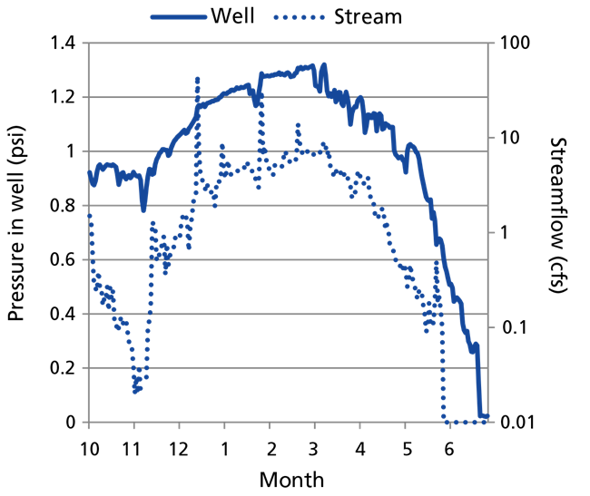
At Tumacácori NHP, streamflow has ceased and groundwater levels are dropping as a result of the overall reduction in flow. Maintaining and replenishing the groundwater adjacent to the river requires a constant flow of river water; without it, evaporation, transpiration (both of which increase in extreme summer temperatures), and loss to surrounding deeper groundwater all combine to lower the surface-water level below the roots of riparian vegetation (Figure 2).
An additional factor contributing to the lack of streamflow at Tumacácori NHP is drought. The Southwest has been in a drought for more than 10 years. Reduced precipitation has reduced the amount of surface flow in regional rivers, as well as groundwater levels. Increased temperatures also put more stress on plants and increase the rate of evaporation.
Conclusions
In and along the Santa Cruz River, water levels are decreasing due to reduced inputs to the effluent-driven Santa Cruz River, coupled with more than 10 years of drought. Negative impacts to the biota directly dependent on water, such as fish and the magnificent riparian gallery forests at Tumacácori NHP, are resulting. In addition, the amount of water discharged by the NIWTP will likely be further reduced in the near future, as Mexico is expected to repatriate up to the full 3 mgd of “free” water that previously flowed into the Santa Cruz. This reduction, combined with the ongoing drought and changes to the stream water–groundwater interaction, will mean further changes in the ecology of the aquatic and riparian systems of Tumacácori NHP.
Ecologists can’t predict exactly what those changes will look like, but with a continued reduction in river flow, the system may eventually resemble the pre-1951 river, with new animal and plant communities responding to the less-reliable availability of surface and groundwater. Intermittent flow, dependent on precipitation events, may create microhabitats for a number of fish and other taxa. Depending on the tendency of underlying geology to force groundwater either to or near the surface, the cottonwood gallery forest may become interspersed with mesquite woodland or vegetation communities more typical of the drier adjoining uplands. What does seem certain is that the natural systems of Tumacácori NHP are about to enter a new phase of anthropogenic change.
For more information, contact the Sonoran Desert Network.
Works Cited
Prichard, H. A., and C. A. Scott. 2013. Interbasin water transfers at the U.S.–Mexico border city of Nogales, Sonora: Implications for aquifers and water security. International Journal of Water Resources Development, February 20.
Stromberg, J. C., R. Tiller, and B. Richter. 1996. Effects of groundwater decline on riparian vegetation of semiarid regions: The San Pedro, Arizona. Ecological Applications 6(1):113–131.
