The geology of Tonto National Monument played an essential role in the lives of the Salado people, providing the raw material from which they shaped tools and the building blocks for their dwellings and terraces.

NPS
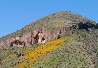
Geologic processes of erosion and deformation also created the caves and alcoves in which the Salado people constructed their homes - the cliff dwellings for which the monument is best know - and the major stream systems vital to prehistoric farming in the Tonto Basin.
By studying geologic processes, archeologists learn not only about prehistoric people’s resource access and decisions, but also about the cycles of deposition and erosion that have affected an archaeological site since its construction. Archeologists use this knowledge to inform their decisions in interpretation, site reconstruction, and chronology building.
The Shaping of the Tonto Basin
The first geologic events we know about in central Arizona took place between 1.5 and 2 billion years ago. Seas covered central Arizona and great thicknesses of sedimentary and volcanic rocks were deposited. When the seas withdrew, the whole area was lifted, folded, and vaulted during a period of structural deformation. Known as the Mazatzal Revolution, this period culminated in the vast mountainous intrusions of granitic igneous rock between 1.2 and 1.5 million years ago (Damon and Giletti 1961). Following the Mazatzal Revolution, the region was subjected to perhaps as much as 100 million years of erosion (Sharp 1940), which wore the land surface down to an almost featureless plain. An encroaching shallow sea then lay down the layers of siltstone, sandstone, and dolomite comprising the Apache Group - the geological group inclusive of most of the rocks exposed in Tonto National Monument.
Thin basalt flows and fine-grained volcanic debris indicate volcanic activity followed the deposition of the Apache Group sedimentary rocks. Perhaps during the same period - estimated as being as distant as 1 billion years ago - great masses of diabase intruded into the Apache Group rocks as dikes and sills. Subsequent erosion erased evidence of the intervening years, but approximately 0.5 billion years ago, central Arizona was once again submerged by sea water.
Like the sea that deposited the Apache Group stones, the Paleozoic seas (185 to 520 million years ago), resulted in accumulations of sedimentary rock and vast thicknesses of limestone. Most of the rocks deposited during this period later eroded, again leaving a sketchy record of geological events until approximately 10 to 30 million years ago, when tremendous forces wrenched apart the rocks, raising up huge blocks, and dropping others down in a jumbled mass of mountainous terrain through which molten rock was interjected and overlain.
Corresponding with the latter millennia of the uplift was downcutting by streams and rivers, including the Salt River, which carried debris from the uplands to the surrounding lowlands, where the sediments gradually hardened into a natural cement. The gravels swept from the highlands into the low areas of the basin accumulated into the Gila Conglomerate, a cemented mass filling the centers of the major basins in the region. Water erosion began to cut out the caves and alcoves now famous for the Salado cliff dwellings between 50,000 and 400,000 years ago, and by 10,000 years ago, the Salt River had carved the Tonto Basin into a landscape similar to that of today.
Exposed Rocks

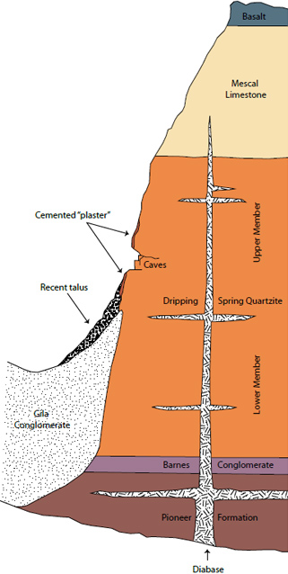
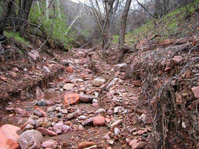
The rocks exposed in Tonto National Monument are principally sedimentary rocks of the Apache Group and more recent Gila Conglomerate. Some bodies of diabase are present, and a veneer of relatively recent rock debris covers parts of the lower slopes and canyon floors. The Apache Group, of which the oldest deposit visible is Pioneer Formation siltstone, were deposited a little over 1 billion years ago during Precambrian time. The youngest material, however, is actively accumulating on the slopes and canyon floors as the Dripping Spring Quartzite and Mescal Formation in the cliffs and slopes immediately above continue to erode.
Apache Group
Pioneer Formation
The oldest Apache Group stones visible in the monument consist of Pioneer Formation siltstone, the maroon-colored stone cropping out in the lower flanks of Cholla Canyon south of the Visitor Center. Some rocks of the Pioneer Formation tend to break into thin plates, which were useful to the Salado people for weapon and tool manufacture.
Barnes Conglomerate
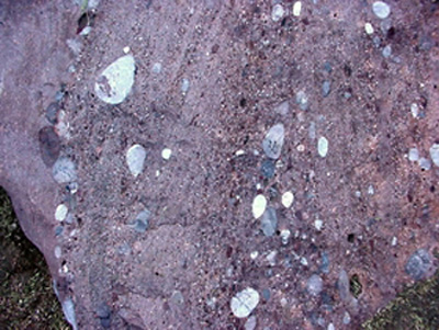
Lying directly above the Pioneer Formation is a 5 - 20 foot think strip of Barnes Conglomerate, a mass of naturally cemented sand and rounded, water-worn pebbles. The pebbles are even older rock, including quartzite, white vein quartz, jasper, and volcanic rocks. The sand component of the stone is feldspar-rich arkose, which gives the Barnes Conglomerate its distinctive pinkish color. Most of the Barnes Conglomerate lies beneath the ground surface in Tonto National Monument, but a wash in Cave Canyon cuts deep enough to expose a section of the layer.
Dripping Spring Quartzite
The Dripping Spring Quartzite consists of a lower member (composed of reddish brown sandstone and quartzite) and an upper member (composed of black, gray, red, and brown claystone, siltstone, sandstone, and quartzite). Dripping Spring Quartzite is composed primarily of quartz and feldspar, but also contain a very small amount of carbon and extremely find grains of pyrite disseminated through the rock. The red and brown colors in unweathered exposures are provided by the feldspar, while gray and black colors derive from the carbon and pyrite inclusions. In weathered stone, the feldspar minerals have turned in part to clay and the carbon and pyrite have oxidized, resulting in pale brown and yellow coloration..
In Tonto National Monument, all the caves and alcoves used by Salado people formed within the Upper Member of the Dripping Spring Quartzite, where a 50 to 75 foot layer is particularly susceptible to spalling. The caves started to form at least 50,000 years ago, and perhaps as much as 400,000 years ago. As cracks formed in the Upper Member, water weakened the rock by carrying away binding materials in and adjacent to the fractures, enlarging the cracks until portions of the rock separated from the remainder. Rock more resistant to spalling and weathering bounds the upper and lower portions of the caves, acting and floor and ceiling. The caves themselves provided the Salado people with shelter suitable for living and perhaps for defense, while the spalled stones found use as construction material.
Mescal Limestone
Overlying the Dripping Springs Quartzite is Mescal Limestone, which in Tonto National Monument is actually comprised primarily of light gray dolomite, rather than true limestone, although some of the latter is also present. Thin streaks of chert occur in much of the Mescal Formation, forming dark gray horizontal bands. Chert, which is composed of extremely fine-grained quartz, resists erosion, and the bands protrude from the less resistant limestone and dolomite on weathered surfaces. Chert is also an excellent flintknapping material, and served the prehistoric people of Tonto National Monument as stone knives, arrowheads, drills, and other sharp implements.

NPS
Basalt
The sedimentary layers of the Apache Group are capped with a the same basalt flow that resulted in the Hawaiian Islands (DuHamel 2009). The basalt is a dense, fine-grained, dark gray to black rock often bearing a distinctive dark-reddish cast. It commonly contains scattered larger crystals of a lighter colored feldspar mineral. This particular rock found little use by the Salado people of the prehistoric Tonto Basin, who preferred vesicular basalt (basalt bearing spherical holes from gas bubbles) for grinding tools, and chert for sharp implements.
Diabase
Diabase was intruded into the older rocks of the Apache Group perhaps 0.5 to 1 billion years ago. The diabase, which is compositionally similar to basalt, formed as sills (horizontal slabs) and dikes (vertical intrusions) as molten material settled into existing cracks in the sedimentary rocks above. Diabase is typically dark gray-green, due in part to abundant iron and magnesium, and as it weathers, forms a characteristic olive-green soil. Salado people used weathered diabase clays to manufacture some of their ceramic wares (Simon 1996), and slabs of the tougher

NPS
Gila Conglomerate
Gila Conglomerate is the second-youngest rock present in Tonto National Monument. It was deposited between 0.5 and 15 million years ago, and is comprised of naturally cemented gravels, sandstone, and siltstone. The rock is commonly pale yellow to buff in color, and contains individual stones ranging in size from clay particles to boulders several feet in diameter. At the bottom of the Gila Conglomerate, the gravel is commonly cemented by caliche (calcium carbonate deposited by evaporating ground water), clay materials, and silica derived from ground water. This layer of cemented debris plaster is well exposed about 500 yards east of the Visitor Center. Other portions of the Gila Conglomerate, however, lack the cementing elements discussed above, and are therefore gravelly or sandy and easily broken by hand.
Literature Cited
This article was adapted from Robert Raup’s 1962 report entitled Some Geological Features of the Tonto National Monument, and supplemented with the references listed below. Robert Raup’s report is available through the National Park Service archives.
Damon, P.E., and Giletti, B.J.
1961 The Age of the Basement Rocks of the Colorado Plateau and Adjacent Area. New York Academy of Science Annals 91(2):443-453.
DuHamel, Jonathan
2009 Arizona Geologic History: Chapter 1, Precambrian Time when Arizona was at the South Pole. Available online at: http://tucsoncitizen.com/wryheat/2009/08/28/ arizona-geologic-history-chapter-1-precambrian-timewhen- arizona-was-at-the-south-pole/
Sharp, R.P.
1940 Ep-Archean and Ep-Algonkian Erosion Surfaces, Grand Canyon, Arizona. Geological Society of America Bulletin 51:1253-1270.
Prepared by Gail Wade, National Park Service, 2010.
Last updated: February 3, 2015
