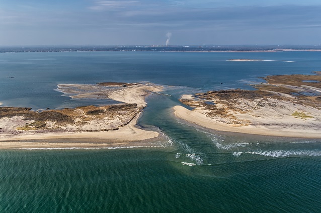
Breaches are channels connecting ocean to bay which form during powerful storms. These natural barrier island features can come and go over time. On October 29, 2012, Hurricane Sandy created a breach within the Otis Pike Fire Island High Dune Wilderness, a federally-designated wilderness area on the eastern end of Fire Island National Seashore. The wilderness breach occurred in a narrow, low-lying area that is historically prone to breaches. This part of the barrier island is called “Old Inlet,” because in the 1800s, a breach occurred here that remained open for approximately 60 years before closing through natural sediment transport processes. The National Park Service will complete a Breach Management Plan/Environmental Impact Statement (EIS) to determine how best to manage the breach within Fire Island’s wilderness area. The science summarized here and public input will support the planning process.
Shifting Sands of the Breach
Longshore transport, also called littoral drift, is one of many natural processes controlling the movement of sediment to, from, and across Fire Island and impacting the barrier island’s shape and position over time. Waves typically approach from the southeast and cause sediment to move westward along Fire Island’s ocean shoreline. Natural processes like littoral drift and aeolian, or wind-driven, transport cause sand to shift from place to place and from formation to formation. Natural processes controlling the shape of the barrier island also influence the shape and position of the wilderness breach. As a result of natural sediment transport processes and storms, the wilderness breach migrated west, which is typical of breaches on Long Island. Shoreline position data, measurements of water depth, and aerial photography collected as part of monitoring efforts show that the breach is dynamic, but it has been relatively stable since 2013.
When it opened, the breach displaced sand from the barrier island into Great South Bay. Waves reworked the sand into flood and ebb shoals, accumulations of sand that occur on the bay side (flood) and ocean side (ebb) of the breach. Over time, these shoals will serve to widen the island, provide platforms for the growth of new salt marsh or other habitats, and enhance the resilience of the barrier island to future storms and sea level rise. The breach has caused localized erosion immediately to the west. However, the ebb shoal that formed on the ocean side has remained relatively small and stable, indicating that the breach is not interrupting the sediment transport system. Sediment continues to move west along the ocean shoreline with littoral drift.
The Future of the Breach
The breach will continue to change. Future storms will cause further changes to the shape and storms will cause further changes to the shape and scientists cannot be sure how the breach will change, sediment cores taken to the east and west of the breach reveal a layer of clay deposits which should limit its migration.
The National Park Service will release the Draft Fire Island Wilderness Breach Management Plan/Environmental Impact Statement (Draft Breach Plan/EIS) to evaluate alternatives for managing the wilderness breach. The desired outcome of the plan is to ensure the continued integrity of the natural and cultural features at Fire Island National Seashore and in Great South Bay, while protecting human life and managing the risk of economic and physical damage to surrounding ecosystems. The Draft Breach Plan/EIS was prepared using the best available science and in accordance with the National Environmental Policy Act, the National Historic Preservation Act, and in compliance with all applicable laws, regulations, and policies.
Last updated: May 2, 2018
