Last updated: July 28, 2023
Article
The Emerald Necklace: Boston's Green Connection
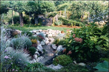
We want a ground to which people may easily go after their day's work is done, and where they may stroll for an hour, seeing, hearing and feeling nothing of the bustle and jar of the streets, where they shall, in effect, find the city put far away from them.... We want, especially, the greatest possible contrast with the restraining and confining conditions which compel us to walk circumspectly, watchfully, jealously, which compel us to look closely upon others without sympathy.¹
When landscape architect Frederick Law Olmsted delivered his lecture Public Parks and the Enlargement of Towns in Cambridge, Massachusetts, in 1870, Boston was an overcrowded, noisy, and dirty city. Concerned with the health and happiness of Bostonians restricted to these unhealthy surroundings, the city hired Olmsted to design a park system. The series of parks he designed over the next several years is known as the Emerald Necklace. Each unique "jewel" in the Emerald Necklace—from lovely waterways to botanical gardens to peaceful meadows to tree museums—plays a vital role in linking the citizens of Boston together through nature.
¹Frederick Law Olmsted, Public Parks and the Enlargement of Towns, 1870.
About This Lesson
This lesson plan is based on the National Register of Historic Places registration file, "Olmsted Park System," and other sources related to Frederick Law Olmsted and the Emerald Necklace. Lisa Marsh, Boston Park Ranger, and Pamela Snow, former Boston Park Ranger, wrote The Emerald Necklace: Boston's Green Connection. Jean West, education consultant, and the Teaching with Historic Places staff edited the lesson. TwHP is sponsored, in part, by the Cultural Resources Training Initiative and Parks as Classrooms programs of the National Park Service. This lesson is one in a series that brings the important stories of historic places into classrooms across the country.
Where it fits into the curriculum
Topics: This lesson could be used in U.S. history, social studies, and geography courses in units on urban expansion in the late 19th century or city planning.
Time period: Late 19th century to early 20th century
United States History Standards for Grades 5-12
The Emerald Necklace: Boston's Green Connection relates to the following National Standards for History:
Era 4: Expansion and Reform (1801-1861)
-
Standard 2B- The student understands the first era of American urbanization.
Era 6: The Development of the Industrial United States (1870-1900)
-
Standard 1B- The student understands the rapid growth of cities and how urban life changed.
-
Standard 1D- The student understands the effects of rapid industrialization on the environment and the emergence of the first conservation movement.
Curriculum Standards for Social Studies
National Council for the Social Studies
The Emerald Necklace: Boston's Green Connection relates to the following Social Studies Standards:
Theme I: Culture
-
Standard A - The student compares similarities and differences in the ways groups, societies, and cultures meet human needs and concerns.
-
Standard C - The student explains and give examples of how language, literature, the arts, architecture, other artifacts, traditions, beliefs, values, and behaviors contribute to the development and transmission of culture.
-
Standard D - The student explains why individuals and groups respond differently to their physical and social environments and/or changes to them on the basis of shared assumptions, values, and beliefs.
Theme II: Time, Continuity and Change
-
Standard C - The student identifies and describes selected historical periods and patterns of change within and across cultures, such as the rise of civilizations, the development of transportation systems, the growth and breakdown of colonial systems, and others.
-
Standard F - The student uses knowledge of facts and concepts drawn from history, along with methods of historical inquiry, to inform decision-making about and action-taking on public issues.
Theme III: People, Places and Environments
-
Standard A - The student elaborates mental maps of locales, regions, and the world that demonstrate understanding of relative location, direction, size, and shape.
-
Standard B - The student creates, interprets, uses, and distinguishes various representations of the earth, such as maps, globes, and photographs.
-
Standard C - The student uses appropriate resources, data sources, and geographic tools such as aerial photographs, satellite images, geographic information systems (GIS), map projections, and cartography to generate, manipulate, and interprets information such as atlases, data bases, grid systems, charts, graphs, and maps.
-
Standard D - The student estimates distance, calculate scale, and distinguish's other geographic relationships such as population density and spatial distribution patterns.
-
Standard E - The student locates and describes varying land forms and geographic features, such as mountains, plateaus, islands, rain forests, deserts, and oceans, and explain their relationships within the ecosystem.
-
Standard G - The student describes how people creates places that reflect cultural values and ideals as they build neighborhoods, parks, shopping centers, and the like.
-
Standard H - The student examine, interprets, and analyze physical and cultural patterns and their interactions, such as land uses, settlement patterns, cultural transmission of customs and ideas, and ecosystem changes.
-
Standard I - The student describes ways that historical events have been influenced by, and have influenced physical and human geographic factors in local, regional, national, and global settings.
Theme IV: Individual Development and Identity
-
Standard B - The student describes personal connections to places associated with community, nation, and world.
-
Standard E - The student identifies and describes ways regional, ethnic, and national cultures influence individuals daily lives.
-
Standard F - The student identifies and describes the influence of perception, attitudes, values, and beliefs on personal identity.
-
Standard H - The student works independently and cooperatively to accomplish goals.
Theme V: Individuals, Groups, and Institutions
-
Standard F - The student describes the role of institutions in furthering both continuity and change.
-
Standard G - The student applies knowledge of how groups and institutions work to meet individual needs and promote the common good.
Theme VII: Production, Distribution and Consumption
-
Standard F - The student explains and illustrate how values and beliefs influence different economic decisions.
Theme VIII: Science, Technology and Society
-
Standard B - The student shows through specific examples how science and technology have changed people's perceptions of the social and natural world, such as in their relationship to the land, animal life, family life, and economic needs, wants, and security.
Theme IX: Global Connections
-
Standard F -The student demonstrate understanding of concerns, standards, issues, and conflicts related to universal human rights.
Theme X: Civic Ideals and Practices
-
Standard D - The student practice forms of civic discussion and participation consistent with the ideals of citizens in a democratic republic.
-
Standard E - The student explain and analyze various forms of citizen action that influence public policy decisions.
-
Standard I - The student explain the relationship between policy statements and action plans used to address issues of public concern.
Objectives for students
1) To determine how 19th-century urban conditions influenced the development of parks.
2) To examine Frederick Law Olmsted's concept of parks and how his beliefs were reflected in his design of the Boston Park System.
3) To explain how topography impacted the development of Boston's Park System.
4) To discover ways to respond to current and future needs of their local cities through open space planning.
Materials for students
The materials listed below either can be used directly on the computer or can be printed out, photocopied, and distributed to students. The maps and images appear twice: in a smaller, low-resolution version with associated questions and alone in a larger version.
1) two maps showing changes in the topography of Boston;
2) three readings about the history of Boston and the vision and contributions of Frederick Law Olmsted to Boston's Park System;
3) one drawing of the Emerald Necklace;
4) four photos of Boston and the Emerald Necklace.
Visiting the site
Visitors to Boston may visit the Emerald Necklace park system independently or participate in walks or bicycle rides led by a Boston Park Ranger. For more information on the sites and educational programs, contact Boston Park Rangers, Boston Parks and Recreation Department, 1010 Massachusetts Avenue, Boston, MA 02118, or visit their web site. Boston Park Rangers also offer a variety of other historical and environmental programs within the Emerald Necklace park system.
Getting Started
Inquiry Question
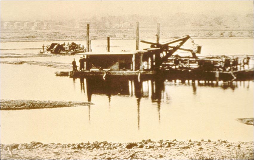
What appears to be taking place in this photo?
Setting the Stage
In 1870, the city of Boston was an overcrowded, noisy, and dirty place. Its population had expanded rapidly because of the Industrial Revolution, and the peninsular port city was crammed with buildings and people. Many of the people who lived in the crowded city did not have the opportunity to travel to the country for fresh air and relaxation. In 1875, the Boston City Council passed a Park Act to help address these concerns. The park commissioners turned to Frederick Law Olmsted, the landscape architect who had created New York City's Central Park, to plan a park system for the city that would provide residents with an opportunity to enjoy the benefits of nature.
Frederick Law Olmsted believed that planned parks and open spaces improved the health and disposition of those who endured the claustrophobic and often unsanitary conditions of city life. For Boston, he envisioned a "Green Ribbon" of parks that would encircle the city. Such a system would suit the geography of Boston as well as allow easier access to nature than one large central park. Over the next several years, he and his firm would create and weave together a series of parks that became known as Boston's Emerald Necklace.
Locating the Site
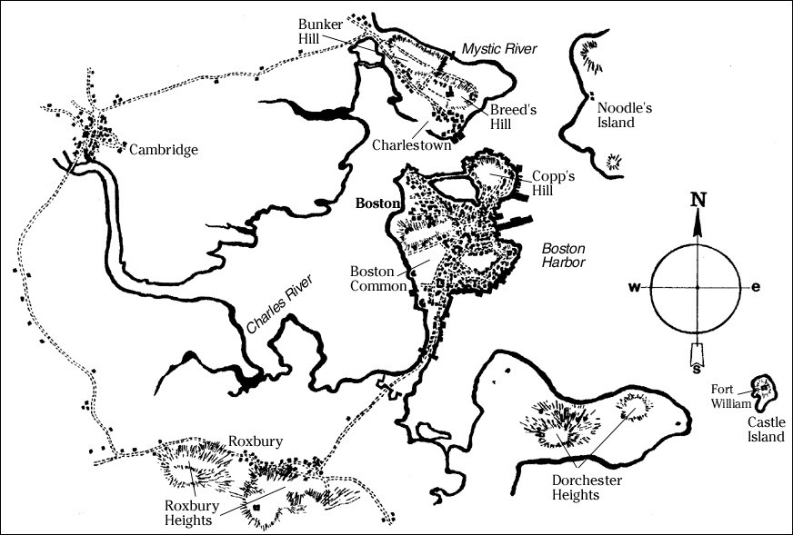
Boston, 1775.
Boston today.
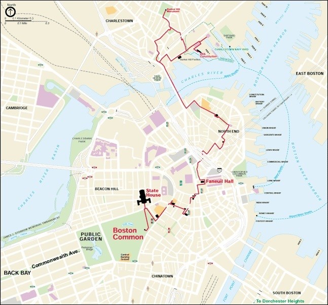
(National Park Service)
Few cities have undergone such drastic changes in geography as Boston. Starting as early as 1742, the city began to fill in the shallows near the shore and build such structures as Faneuil Hall, the first open air market place and town meeting hall in Boston. By the 1820s and into the 1830s, hilltops were being scraped and used as landfill. By 1860, the Back Bay, which had been an environmental concern for decades due to sewage dumping, had been filled in.
The annexations by Boston of several neighboring communities including Roxbury (by 1867) and Dorchester (by 1869) allowed Boston to expand in terms of both population and geographic size. Following these annexations, Boston could, for the first time, acquire larger tracts of land for development of major parks.
Questions for Maps 1 and 2
1. Based on Map 1, what geographical features of Boston limited its ability to expand?
2. Locate the following features on Map 1: the Boston Common, the Charles River, the Back Bay (the water at the back edge of the Boston Common), and the communities of Roxbury and Dorchester. What changes in land mass have occurred between 1775 and the present? How did these changes occur?
3. How might Boston's history have been different if the Back Bay and other areas had not been filled?
4. How did adding large communities, such as Roxbury and Dorchester, affect Boston's ability to accommodate parks?
Determining the Facts
Reading 1: Boston's First Parks
For 200 years, the only place for Bostonians to escape the crowded conditions of the city was the 48-acre parcel of land known as the Boston Common. In 1634, the residents of Boston selected a tract of land to serve as a grazing area for cattle and a gathering place for people. It was also decided that no buildings would be constructed on this land without the approval of all citizens. Bostonians made a conscious decision to maintain an open, green space in their new settlement. The Boston Common, now the oldest park in the country, would remain the only open green space in Boston until 1837.
At the back edge of the Boston Common was Back Bay. This bay was flooded by the ocean tides twice a day via the Charles River. In 1821, the Roxbury Mill Dam was built, which housed a mill that was designed to take advantage of the tidal waters. This dam cut off the tidal flow of the Atlantic Ocean to the Back Bay area, blocking the cleansing tides that used to wash out the sewage from the bay.
However, people continued to dump their raw sewage into the Back Bay creating an awful odor. It was said that this area contained "the foulest marsh and muddy flats to be found anywhere in Massachusetts without a single attractive feature, a body of water so foul that even clams and eels cannot live there, and a place that no one will go within a half mile of in the summertime unless it was absolutely necessary," and in 1849, the Boston Board of Health described it as a "nuisance, offensive and injurious to the large and increasing population residing upon it."¹
What did the city do to solve the problem? In 1837, the city of Boston began filling in a portion of the Back Bay just beyond the boundaries of the Boston Common. This portion of land became Boston's second park, the Public Garden.
The Public Garden added 24 acres of flowers, trees, and a man-made lagoon to Boston's open space. Although the Public Garden was a great improvement to the area, the non-filled parts of Back Bay continued to be a foul-smelling nuisance. In 1860, responding to environmental, health, and population pressures, the State of Massachusetts brought landfill from Needham, Massachusetts and filled in the rest of the Back Bay.
The reclaimed land from Back Bay allowed Boston to grow beyond its original boundaries. Boston's third park, Commonwealth Avenue Mall, was planned as a central green for this newly filled area. It was a long, narrow stretch of green with stately rows of tall elm trees that served as a popular promenade along what became Boston's most elegant street.
An 1859 report by the Committee on the Improvement of the Public Garden describes how Bostonians were beginning to think about the importance of setting aside more land for parks in spite of the limited amount of land available:
While other cities are expending fabulous amounts in the improvements of parks, squares, gardens, and promenades, what should we do? To be behind in these matters would not only be discreditable to our city, but positively injurious to our commercial prosperity, and in direct opposition to the wishes of a vast majority of the citizens....The area of our city is too small to allow the laying out of large tracts of land for public parks, and it behooves us to improve the small portions that are left to us for such purpose.
In Boston, the prospect of setting aside green space and building parks was ultimately dictated by the topography of the land and the already existing population.
Questions for Reading 1
1. Why did Boston's early residents set aside public land?
2. Why was the Back Bay an environmental and health concern in the early 19th century?
3. What impact did the filling in of the Back Bay have on the city?
4. Based on Maps 1 and 2 and Reading 1, how did Boston's geography influence the development of its first parks?
Reading 1 was compiled from Walter Muir Whitehill, Boston: A Topographical History (Cambridge, Mass.: Belknap Publishing of the Harvard University Press, 1959) and Cynthia Zaitzevsky, Frederick Law Olmsted and the Boston Park System (Cambridge, Mass.: Belknap Publishing of the Harvard University Press, 1982).
¹ Walter Muir Whitehill, Boston: A Topographical History (Cambridge, Mass.: Belknap Publishing of the Harvard University Press, 1959), 140.
Determining the Facts
Reading 2: The Green Connection
In 1875, the Boston City Council passed a Park Act. The Boston Park Commissioners were finally able to propose a park system where people could "in effect, find the city put far away from them."¹ The commissioners, empowered by the Park Act, approached Frederick Law Olmsted in June of 1878 to be their professional advisor for the proposed park system. Olmsted (1822 -1903) is thought of as the "Father of Landscape Architecture" in the United States since he was the first person in this country to make a profession out of designing parks and other landscapes. His landscape design firm's work can be found in 45 states and several countries throughout the world. Perhaps his most famous work was Central Park (1857-1863) in New York City. In fact, the success of his design in Central Park was a model for cities such as Boston, who saw the positive influence rural parks had on city dwellers.
Between 1878 and 1881, Olmsted was able to study the proposed sites in the park system. During this time he formed the vision for the park system as expressed in his letter to the Chairman of the Parks Commission: "Sir, The Park System for Boston, advised by your Commission, though of smaller area than that of many other cities, differs from all others in the scope of its landscape design; and this is, in part due to topographical opportunities possessed by Boston, which, for the purpose in view, are probably unrivaled."² He further explained the advantages of a series of parks linked together: "It will be obvious at a glance, to any one having a superficial knowledge of several localities named upon the map, that, if due advantage is taken of the distinctive capabilities of each and due respect paid to the distinctive limitations of each, the results to all concerned...will be incomparably more interesting and valuable than they can possibly be under a policy such as seems to be commonly entertained of regarding each proposed park and parklet as an independent affair...."³
Olmsted believed that overcrowding in cities made people nervous and wary of each other as well as susceptible to disease. Therefore, he felt that "city dwellers need contact with the natural world in order to preserve not only their physical health but also their mental tranquility."4 In order for all city dwellers to have contact with the natural world, Olmsted envisioned a linked chain of parks as more beneficial than a large single park. The linked parks together would fill a need for the entire city, not just the neighborhoods closest to a large, central park. He saw as an additional benefit that all parts of the city would be connected through the chain of parks. Olmsted also believed that each park site had its own genius that it could contribute to the whole system stating: "The fitness of a site will largely be found in its adaptation to supply some form of park refreshment that others of the series are ill-adapted to supply....Regarding the natural opportunities and limitations of the several localities to be named below, it will be found that each will, through a judicious method of improvement, be adapted to induce a distinct impression; and that, in each, the space to be applied to this impression is sufficient for this purpose."5
Olmsted's idea of a chain of parks allowed Bostonians to travel for miles surrounded by greenery, even though many of the individual parks were quite small. New parks were planned to connect with the existing Boston Common, Public Garden, and Commonwealth Avenue. In areas where space was too limited for parks, the plan called for parkways, roadways that were widened and planted with overhanging trees. In his report to the Board of Commissioners in 1881, Olmsted called his chain of parks the "Green Ribbon." However, over the years it became known as the "Emerald Necklace." Today, the Emerald Necklace remains a model in urban landscape design. Other cities and towns have used Boston's model to design their own greenways. The concept of a greenway has also spread to rural areas, as a method of conserving wilderness areas. For example, the Appalachian Trail is a greenway that connects Georgia to Maine by way of a hiking trail.
Questions for Reading 2
1. What are some of the reasons why Boston decided to build a series of small parks instead of one large park?
2. What did Olmsted originally call the Emerald Necklace?
3. Olmsted believed each of the smaller parks had unique recreational opportunities. How does Olmsted say he will decide on the fitness of a park site? What advantage did he see in coordinating the planning for all the parks together rather than treating each park independently?
Reading 2 was compiled from Walter Muir Whitehill, Boston: A Topographical History (Cambridge, Mass.: Belknap Publishing of the Harvard University Press, 1959); Frederick Law Olmsted, Boston Parks and Parkways - A Green Ribbon, Seventh Annual Report of the Board of Commissioners of the Department of Parks for the City of Boston for the year 1881, City Document No. 16, 1882, pp. 24-28, as taken from S. B. Sutton, ed., Civilizing American Cities: A Selection of Frederick Law Olmsted's Writings on City Landscapes (Cambridge, Mass.: MIT Press, 1971); Frederick Law Olmsted, Public Parks and the Enlargement of Towns, 1870; and Cynthia Zaitzevsky, Frederick Law Olmsted and the Boston Park System (Cambridge, Mass.: Belknap Publishing of the Harvard University Press, 1982).
¹Frederick Law Olmsted, Public Parks and the Enlargement of Towns, 1870.
²S. B. Sutton, Civilizing American Cities: A Selection of Frederick Law Olmsted's Writings on City Landscapes (Cambridge, Mass.: MIT Press, 1971), 223.
³Ibid.
4Ibid.
5Ibid.
Determining the Facts
Reading 3: Creating the Jewels of the Emerald Necklace
Frederick Law Olmsted began his first Boston park project in 1878 in the newly created open land known as the Back Bay Fens (marshy area or swamp.) Olmsted worked with city engineers not only to solve the sanitation problem but to restore the area to its original salt marsh condition. His design allowed for a continuous flow of water by using flood gates to control the levels of the water.
The Muddy River, which flowed into the area, was diverted to flow into the Charles River. Olmsted commented on the idea of having a marsh in the city saying that: "there may be a momentary question of its dignity and appropriateness. . .but [it] is a direct development of the original conditions of the locality in adaptation to the needs of a dense community."¹
At the same time that Olmsted was working to create the Back Bay Fens he also became involved in another project in Boston. Charles Sprague Sargent turned to Olmsted for help in establishing and maintaining an arboretum, a collection of trees and shrubs, from all over the world. Olmsted initially worried that combining a park and an arboretum would be difficult because they were created for different purposes. One of the challenges was to try and blend the scientific world with a picturesque world. However, Olmsted gradually embraced the idea and developed preliminary plans in 1878. Olmsted and Sargent, first director of Boston's Arnold Arboretum, spent four years trying to convince the park commission to allow the Arnold Arboretum to become a part of the growing Boston Park System. In 1882, an agreement was signed between Harvard University and The City of Boston by which the city would own the land and lease it to Harvard for a dollar a year for a thousand years. The Arboretum is now a 265-acre jewel in the Emerald Necklace.
Construction of the Arboretum began in 1883 and was well under way when Frederick Law Olmsted undertook his next project for Boston, Franklin Park. Originally called West Roxbury Park, the name was changed in hopes of attracting funding from the Benjamin Franklin estate. The funding did not materialize, but the name has endured. Olmsted felt that Franklin Park was the most critical link in the whole system because its size and topographical features helped people feel more in contact with nature: "The all important feature of the West Roxbury (Franklin Park) site is a gentle valley.... Relieved of a few houses, causeways, and fences, left with unbroken surface of turf and secluded by woods on the hillsides, this would at once supply a singularly complete and perfect though limited example of a type of scenery which is perhaps the most soothing in its influence on mankind of any presented by nature."²
Some of the landowners around the proposed Franklin Park were reluctant to give up their land. In order for Olmsted to create the park, some land had to be secured by the city through eminent domain. Eminent domain gives the city the right to purchase land from owners at a fair price for the good of the city. Eventually, 500 acres of land were secured, Olmsted finalized the design plans in 1884-1885, and construction began in 1885.
In 1880, Frederick Law Olmsted suggested to the Parks Commission that the Muddy River be included in the plan for the Emerald Necklace. The little stream was brackish (a mixture of salt and fresh water), a source of disease, and a breeding ground for mosquitoes. In 1881, John C. Olmsted, Frederick Law Olmsted's stepson, drew up plans for the Muddy River improvement. This plan included changes such as making the Muddy River a gently winding stream, converting a cattail swamp to a large pond (Leverett Pond), and connecting it to Ward's Pond by a stream. Sensitive to the landscape, Olmsted blended man-made portions with natural water and land formations. Olmsted described it as "a chain of picturesque fresh-water ponds, alternating with attractive natural groves and meads, the uppermost of these ponds being Jamaica Pond."³ His plan also included parkways, paths, and bridle paths (for riding horses). Construction began on the Muddy River in 1890, 10 years after Olmsted's initial suggestion for improvement. The area that includes Leverett Pond, Willow Pond, and Ward's Pond was singled out and called Leverett Park. In 1900, the named was changed to Olmsted Park to honor its designer.
Jamaica Pond, located right next to Olmsted Park, was the only large fresh-water pond in the city (it provided water to residents until 1848), and it was a logical place for a park. Ice houses built in the 1870s detracted from the scenery and contaminated the water, which convinced both the park commissioners and Olmsted to incorporate the pond as a park in the Emerald Necklace. Olmsted saw Jamaica Pond as "a natural sheet of water, with quiet, graceful shores, rear banks of varied elevation and contour, for the most part shaded by a fine natural forest-growth to be brought out over-hangingly, darkening the water's edge and favoring great beauty in reflections and flickering half-lights."4
Because Jamaica Pond was a popular area for large summer homes, it was necessary for Boston to use eminent domain to acquire the land around the pond. Olmsted retained two of these houses in his plan so that the buildings could be used as refectories—places to get refreshments. Olmsted made few changes to the landscape, and Jamaica Pond still largely reflects Olmsted's vision for it.
Olmsted's chain of parks was almost complete. He wanted to integrate the existing open green spaces in Boston into the park plan. He used Commonwealth Avenue as a connection between the Back Bay Fens and the Public Garden. Although he did not design Commonwealth Avenue Mall, the Public Garden, or the Boston Common, Olmsted either modified already existing plans or implemented new plantings and pathways. Frederick Law Olmsted had succeeded in encircling Boston with a living, invigorating "green ribbon."
Questions for Reading 3
1. What problems did Olmsted face in creating the individual parks and the connections between them?
2. What is eminent domain? Why did the city use it? How do you think the people felt who were forced to move, even though they were paid?
3. Why did Olmsted see Franklin Park as the critical piece in his plan?
4. Why did Olmsted feel it was important to include Jamaica Pond in the Emerald Necklace?
5. Based on the descriptions, which of the parks or elements in the Emerald Necklace appeals to you the most and why?
Reading 3 was compiled from S. B. Sutton, Civilizing American Cities: A Selection of Frederick Law Olmsted's Writings on City Landscape (Cambridge, Mass.: MIT Press, 1971) and Cynthia Zaitzevsky, Frederick Law Olmsted and the Boston Park System (Cambridge, Mass.: Belknap Publishing of Harvard University Press, 1982).
¹Cynthia Zaitzevsky, Frederick Law Olmsted and the Boston Park System (Cambridge, Mass.: Belknap Publishing of Harvard University Press, 1982), 57.
²Ibid., 66.
³Ibid.
4Ibid., 87.
Visual Evidence
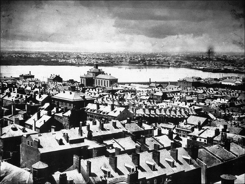
Photo 1: Boston, 1850s.
(Courtesy of The Bostonian Society/Old State House)
Photo 1 is a view of Boston looking from the State House to the West End.
Questions for Photo 1
1. What impression do you get of Boston from this photograph taken in the mid 19th century?
2. What do you think it might have been like to live in this area at the time the photo was taken?
3. Does this photo help you to understand the need for planned parks in large cities? Is so, how?
Visual Evidence
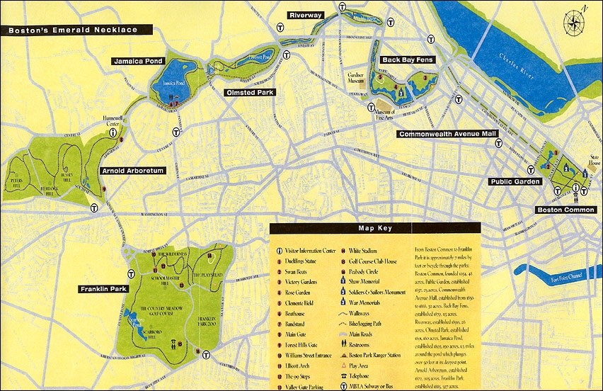
Drawing 1: The Emerald Necklace today.
Questions for Drawing 1
1. Identify the nine parks in the Emerald Necklace and give a brief description of each.
2. Does seeing the layout of the Emerald Necklace help you to understand the value of Olmsted's vision for a series of parks rather than one large park? If so, how?
Visual Evidence
Photo 2: Dredging the Back Bay, 1882.

Questions for Photo 2
1. What is happening in this photo?
2. What does this photo tell you about the process of constructing parks?
Visual Evidence
Photo 3: The Muddy River during construction, 1892.
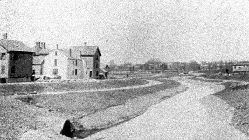
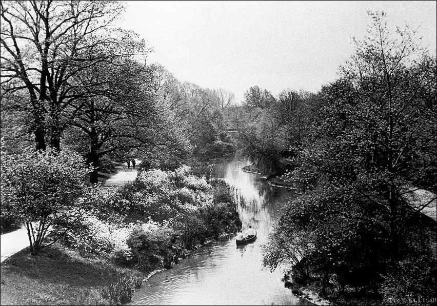
Photo 4: The Muddy River after construction, 1920.
Questions for Photos 3 and 4
1. Is there evidence in Photo 3 that the original river has been altered by human effort? Explain.
2. Looking at both photos, what changes does Photo 4 document that have taken place since Photo 3 was taken?
3. If you had not seen Photo 3, do you think you could tell that the landscape in Photo 4 was man-made? Why or why not?
Putting It All Together
The following activities engage students in a number of ways that let them discover how landscape artists and park planners relate to the environment around them.
Activity 1: Plan Your Own Park
In preparation for this activity you will want to get not only a current street map of your area but also copies or scans of historical maps (from a local historical society), topographical maps, and zoning maps (from the city/county planning commission or survey office).
1. Ask students to look at the maps, comparing and contrasting the type of information each map contains.
2. Direct students to locate existing parks and or park system sites on the maps.
3. Divide students into groups of 4 or 5 and have them pretend that they represent a landscape architecture firm. Ask them to discuss possible locations and designs for a park, park system, or greenway, taking into account topography, developed areas, and zoning restrictions on their maps. Each group should select a final location and list in a written plan details about design elements, recreational features, and descriptive elements.
4. Ask each group to present their proposal to the Parks Commission (the whole class) tracing out on the map where they have located their park, presenting its features, and making an argument for why their design should be implemented. When all the presentations are complete, ask the class, acting as the Parks Commission, to vote on which plan they will adopt.
Activity 2: Parks Brochure
1. Divide the class into groups of 4 or 5 students who will form design teams to create a park brochure.
2. Each team will be asked to create its own brochure, either of the park designed in Activity 1 or of a local park or park system, dividing work so that each student works on one or two parks or focuses on a specific aspect of the park (such as scenic features, environmental benefits, recreational opportunities).
3. Team members should integrate their work into a final brochure. Students may create the brochure with drawings, clippings from existing pamphlets, photographs, or by integrating digital images. The brochure may be handmade or computer generated.
4. Display brochures on bulletin board or send to local parks commission.
Activity 3: Landscape Fun
1. Invite a local landscape architect to speak to the class and show students some before and after images of projects the students will recognize from their area.
2. Ask students to work within a $50 budget to beautify the school by the addition of some landscape element. The design may be done by hand or with a computer landscape-design program. Determine if the PTA, student government, a club, or the school administration is able to fund a small landscape project and if the designer(s) is willing to arrange for volunteer labor to carry out the project. If so, have a contest to determine which is the best design and install the winning project on the school's property.
Emerald Necklace: Boston's Green Connection--
Supplementary Resources
By looking at The Emerald Necklace: Boston's Green Connection, students will learn about Frederick Law Olmsted and his philosophy about parks and cities as well as city life during the Industrial Revolution. Those interested in learning more will find that the Internet offers a variety of interesting materials.
The Emerald Necklace Conservancy
The Emerald Necklace Conservancy website provides a virtual tour of Boston's Emerald Necklace including the individual "jewels" of the necklace and information about each park.
Boston National Historical Park
Boston National Historical Park is a unit of the National Park System. Visit the parks Web pages for the virtual Freedom Trail tour that shows the city's historic sites including Boston Common.
The Arnold Arboretum of Harvard University
Visit the Arnold Arboretum website for more information about this research and educational institution. It manages a collection of hardy trees, shrubs, and vines located on 265 acres in Boston, Massachusetts and associated herbarium and library collections. The grounds were planned and designed by the Arboretum's first director, Charles Sprague Sargent, in collaboration with the landscape architect, Frederick Law Olmsted as part of Boston's Emerald Necklace park system. The landscape and design at Mount Auburn Cemetery by the Massachusetts Horticultural Society helped to pave the way for Charles Sprague Sargent and Frederick Law Olmsted in their creation of the Arnold Arboretum, part of Boston City Park's Emerald Necklace.
Frederick Law Olmsted National Historic Site
Frederick Law Olmsted National Historic Site is a unit of the National Park System. Visit the park's Web pages for a detailed history of Olmsted as well as information about the Olmsted Archives that has historic documentation for Olmsted-designed landscapes. Also featured on the site is the Olmsted Center for Landscape Preservation (OCLP) providing technical assistance to historic properties in cultural landscape research, planning, stewardship and education.
The Cultural Landscape Foundation
The Cultural Landscape Foundation is the only not-for-profit foundation in America dedicated to increasing the public’s awareness of the importance and irreplaceable legacy of cultural landscapes. Visit their website for more information on what cultural landscapes are and what they represent. Also learn about endangered landscapes and grassroots efforts to preserve them.
Library of Congress: Historic American Buildings Survey (HABS)/ Historic American Engineering Record (HAER) Collection
Search the HABS/HAER collection for detailed drawings, photographs, and documentation from their architectural survey of Boston Public Garden, Faneuil Hall, the State House, and other Boston historic properties. HABS/HAER is a division of the National Park Service.
Central Park
The Central Park website provides a detailed history of Frederick Law Olmsted's most famous park as well as a virtual tour.
Urban Parks Online
This Project for Public Places website features Great Park Places, a segment about urban parks from around the world ranging from River Walk in San Antonio, Texas to the Luxembourg Gardens in Paris. The descriptions include photographs, historical information, and an evaluation of what makes each park effective and enjoyable.
Tags
- boston
- landscape architecture
- public parks
- olmsted
- national register of historic places
- nrhp listing
- teaching with historic places
- twhp
- massachusetts
- massachusetts history
- conservation
- art and education
- late 19th century
- gilded age
- progressive era
- leisure
- landscape architect
- olmsted places
- frederick law olmsted
- twhplp
