Last updated: May 8, 2023
Article
The Battle of Honey Springs: The Civil War Comes to the Indian Territory (Teaching with Historic Places)
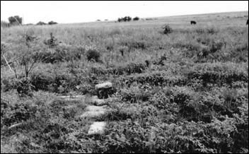
This lesson is part of the National Park Service’s Teaching with Historic Places (TwHP) program.
Hungry and tired, Union troops marched south through early morning rain, July 17, 1863. Despite their weary state, they trekked through Indian territory knowing that just two weeks earlier their fellow soldiers had triumphed at Gettysburg and Vicksburg. Yet as they halted their march behind a ridge in order to rest and eat, the soldiers prepared for what would become a crucial Civil War battle. A battle that would help determine whether the Union or the Confederacy would control the West beyond the Mississippi River.
The Confederate troops that these soldiers would face in the Battle of Honey Springs concealed themselves among the trees lining a nearby water source after which the battle is named. They too had heard of the two recent Confederate defeats which were results of President Abraham Lincoln's "Grand Strategy" to "turn back the Rebels at every opportunity."
The Battle of Honey Springs is important because of its setting in the rolling prairie of what is now eastern Oklahoma, versus the famed theaters of the East. Also significant were the divided Native Americans who fought and died there for both the North and South. The Battle of Honey Springs illustrates how the most destructive conflict in American history moved into what was then Indian Territory and into the lives of its residents who fought to preserve their way of life.
About This Lesson
This lesson is based on the National Register of Historic Places registration file "Honey Springs Battlefield" and other sources. It was made possible by the National Park Service's American Battlefield Protection Program. The lesson written by Mike Adkins, a social studies teacher from the Moore School District, and Ralph Jones, Superintendent, Battle of Honey Springs Historic Site. The lesson was edited by the Teaching with Historic Places staff. TwHP is sponsored, in part, by the Cultural Resources Training Initiative and Parks as Classrooms programs of the National Park Service. This lesson is one in a series that brings the important stories of historic places into the classrooms across the country.
Where it fits into the curriculum
Topics: This lesson could be used in teaching units on the Civil War, particularly the war in the West, on Native American history, or on cultural diversity.
Time period: 1861-1865
United States History Standards for Grades 5-12
The Battle of Honey Springs:The Civil War Comes to the Indian Territory
relates to the following National Standards for History:
Era 4: Expansion and Reform (1801-1861)
-
Standard 1B- The student understands federal and state Indian policy and the strategies for survival forged by Native Americans.Era 5: Civil War and Reconstruction (1850-1877)
-
Standard 2A- The student understands how the resources of the Union and Confederacy affected the course of the war.
-
Standard 2B- The student understands the social experience of the war on the battlefield and homefront.
Curriculum Standards for Social Studies
National Council for the Social Studies
The Battle of Honey Springs: The Civil War Comes to the Indian Territory
relates to the following Social Studies Standards:
Theme I: Culture
-
Standard D - The student explains why individuals and groups respond differently to their physical and social environments and/or changes to them on the basis of shared assumptions, values, and beliefs.
-
Standard E - The student articulates the implications of cultural diversity, as well as cohesion, within and across groups.
Theme II: Time, Continuity and Change
-
Standard D - The student identifies and uses processes important to reconstructing and reinterpreting the past, such as using a variety of sources, providing, validating, and weighing evidence for claims, checking credibility of sources, and searching for causality.
Theme III: People, Places, and Environment
-
Standard A - The student creates, interprets, uses, and distinguishes various representations of the earth, such as maps, globes, and photographs.
-
Standard C - The student uses appropriate resources, data sources, and geographic tools such as aerial photographs, satellite images, geographic information systems (GIS), map projections, and cartography to generate, manipulate, and interpret information such as atlases, data bases, grid systems, charts, graphs, and maps.
Theme VI: Power, Authority, and Governance
-
Standard F - The student explains conditions, actions, and motivations that contribute to conflict and cooperation within and among nations.
Theme X: Civic Ideals, and Practices
-
Standard C - The student locates, accesses, analyzes, organizes, and applies information about selected public issues - recognizing and explaining multiple points of view.
Objectives for students
1) To explain how and why American Indians of the Five Civilized Tribes became involved in a bloody conflict that started a thousand miles away.
2) To examine the effects of the Civil War on the Indian Territory and its citizens.
3) To learn how to interpret and compare battle narratives and use this information to create a map of the events.
4) To discover if distinct ethnic groups from the student's own community have worked together toward a common goal, as they did at Honey Springs.
Materials for students
The materials listed below either can be used directly on the computer or can be printed out, photocopied, and distributed to students. The maps and images appear twice: in a low-resolution version with associated questions and alone in a larger, high-quality version.
1) one map and table showing Indian Territory and its population;
2) three readings about the battle from contemporary accounts by soldiers;
3) one illustration and table of northeastern Oklahoma and the military units involved;
4) two illustrations and one table of the battle.
Visiting the site
Honey Springs Battlefield Park is located in southern Muskogee County and northern McIntosh county in east-central Oklahoma. Take the Checotha/Rentiesville exit off U.S. HWY 69 (approximately 2 1/4 miles north of I-40); then take Business 69 north approximately 1 1/14 miles to Rentiesville Road; Go east 2 miles to edge of battlefield and follow signs to the monuments and visitors center. For further information contact the Superintendent, Battle of Honey Springs, Historic Site, 1863 Honey Springs Battlefield Road, Checotah, OK 74426-6301.
Getting Started
Inquiry Question
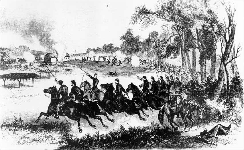
What appears to be happening in this drawing?
When do you think this scene took place?
Setting the Stage
Not everyone who crossed the Mississippi River in the 19th century to establish a new home had moved west by choice. During the middle of the 1800s, for example, most of the people in what is today Oklahoma were Native Americans who were forced there by the federal and several state governments. Dominating the eastern part of the Indian Territory were the Cherokee, Chickasaw, Choctaw, Creek, and Seminole known collectively by European Americans as the Five Civilized Tribes because they adopted many "white" cultural practices.
For centuries these tribes had controlled large sections of what became Tennessee, Georgia, Alabama, and Florida. However, their authority diminished rapidly in the first part of the 19th century because state and territorial governments rarely prevented settlers from encroaching on the land reserved for the tribes. After 1800, many Native Americans, frustrated by these violations, reluctantly left their lands and relocated across the Mississippi. In the 1830s, President Andrew Jackson's policy of Indian removal forced new treaties on tribal members still in the Southeast; these required the five nations to give up virtually all of their remaining holdings. Though some Native Americans moved elsewhere within the region, most unwillingly traveled west. These migrations led to much suffering and many deaths, most notably the Cherokee "Trail of Tears" during the winter of 1838-39.
By 1860 the five nations had created new lives in the Indian Territory. They had built towns, reestablished tribal governments, planted orchards and fields, and expanded their herds of beef. A small percentage continued to hold black slaves, a practice they had followed in their old homes. Available statistics indicate that by the start of the Civil War about one Native American in 50 in the Indian Territory owned slaves. The federal government assisted the tribes by providing annual payments and stationing troops who worked to keep the peace among tribes and to prevent encroachment on Native American lands. Travelers from the east occasionally appeared, passing through in search of fertile land elsewhere, driving cattle from Texas to Kansas or hiding out from the law in remote areas.
In the months following Abraham Lincoln's election to the Presidency, both the North and South increasingly courted tribal leaders. Each side recognized the Indian Territory's importance in controlling the Trans-Mississippi West and its role as a buffer between free state Kansas and slaveholding Texas. Southern leaders also wanted to be able to draw on the area's resources: food, minerals, and manpower. As the tribes received this attention, however, they also realized that this conflict might yet again disrupt their lives.
Setting the Stage was compiled from Grant Foreman, The Five Civilized Tribes (Norman, OK: University of Oklahoma Press, 1934); and R. Halliburton, Jr., Red Over Black: Black Slavery Among the Cherokee Indians (Westport, CT: Greenwood Press, 1977).
|
|
Locating the Site
Map 1: Indian Territory.
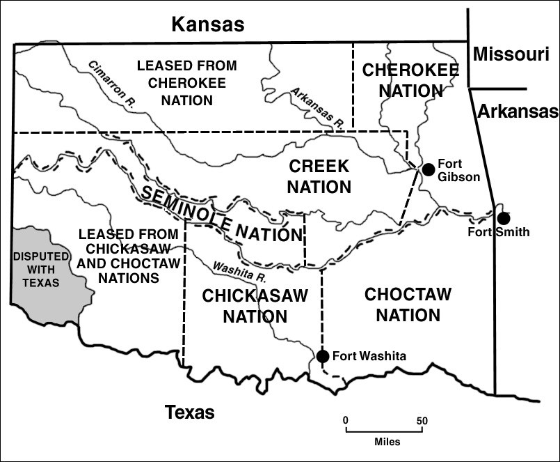
Table 1: Tribal and Slave Populations.
|
Nation |
Tribal Population |
Slave Population |
|
Cherokee |
21,000 |
2,504 |
|
Chickasaw |
5,000 |
917 |
|
Choctaw |
18,000 |
2,298 |
|
Creek |
13,550 |
1,651 |
|
Seminole |
2,267 |
See Note 1 |
Note 1: Figures for the Seminole Nation are not available, but this tribe is known to have held slaves.
Native American tribes were, and continue to be, recognized as sovereign nations by the federal government. What is marked on maps as the Indian Territory was not an official territory of the United States such as Dakota Territory or Colorado Territory.
Questions for Map 1 & Table 1
1. Locate a map of the United States. How many miles is it from Indian Territory (now Oklahoma) to Washington, D.C. and Richmond, Virginia? As the Civil War began, what methods did people in the territory have to communicate with the two capitals? How closely connected to the East do you think people in the Indian Territory felt?
2. Examine Map 1. Make note of the states surrounding the Indian Territory. Which state/states were slaveholding? Which state/states were free?
3. Now examine Table 1. Write on Map 1 the slave population of each Native American tribe.
4. Which of the Five Civilized Tribes would seem most likely to be sympathetic to the Confederacy? Why? Be sure to consider both location and lifestyle. Which would be least sympathetic? Why?
Table 1 is compiled from U.S. Bureau of the Census, Eighth Annual Census (1860), National Archives; Annie Heloise Able, The American Indian as a Slaveholder and Secessionist (Lincoln, Neb.: University of Nebraska Press, 1992) 211; R. Haliburton, Red Over Black: Black Slavery Among the Cherokee Indians (Westport, Conn.: Greenwood Press, 1977) 117.
Reading 1: A View from Indian Territory
|
The State of Arkansas, Executive Department To His Excellency John Ross, Principal Chief Cherokee Nation: Sir: Your people, in their institutions, productions, latitude, and natural sympathies, are allied to the common brotherhood of the slave-holding States. Our people and yours are natural allies in war and friends in peace. Your country is salubrious and fertile, and possesses the highest capacity for future progress and development by the application of slave labor. Besides this, the contiguity of our territory with yours induces relations of so intimate a character as to preclude the idea of discordant or separate action. It is well established that the Indian country west of Arkansas is looked to by the incoming administration of Mr. Lincoln as fruitful fields ripe for the harvest of abolitionism, freesoilers, and Northern mountebanks. We hope to find in your people friends willing to co-operate with the South in defense of her institutions, her honor, and her firesides, and with whom the slaveholding States are willing to share a common future, and to afford protection commensurate with your exposed condition and your subsisting monetary interests with the General Government. As a direct means of expressing to you these sentiments, I have dispatched my aide-de-camp, Lt. Col. J. J. Gaines, to confer with you confidentially upon these subjects, and to report to me any expressions of kindness and confidence that you may see proper to communicate to the governor of Arkansas, who is your friend and the friend of your people. Respectfully, your obedient servant, |
|
Tahlequah, Cherokee Nation His Excellency Henry M. Rector, Governor of Arkansas Sir:I have the honor to acknowledge the receipt of Your Excellency's communication of the 29th ultimo, per your aide-de-camp, Lt. Col. J. J. Gaines.
The Cherokees cannot but feel a deep regret and solicitude for the unhappy differences which at present disturb the peace and quietude of the several States, especially when it is understood that some of the slave States have already separated themselves and withdrawn from the Federal Government and that it is probable others will also pursue the same course. But may we not yet hope and trust in the dispensation of Divine power to overrule the discordant elements for good, and that, by the counsel of the wisdom, virtue and patriotism of the land, measures may happily be adopted for the restoration of peace and harmony among the brotherhood of States within the Federal Union? The relations which the Cherokee people sustain toward their white brethren have been established by subsisting treaties with the United States Government, and by them they have placed themselves under the "protection of the United States and of no other sovereign power whatever." They are bound to hold no treaty with any foreign power, or with any individual state, nor with the citizens of any state. On the other hand, the faith of the United States is solemnly pledged to the Cherokee Nation for the protection of the right and title in the lands, conveyed to them by patent, with their territorial boundaries, as also for the protection for all other of their national and individual rights and interests of persons and property. Thus the Cherokee people are inviolably allied with their white brethren of the United States in war and friends in peace. Their institutions, locality, and natural sympathies are unequivocally with the slave-holding States. And the contiguity of our territory to your State, in connection with the daily, social, and commercial intercourse between our respective citizens, forbids the idea that they should never be otherwise than steadfast friends. I am surprised to be informed by Your Excellency that "it is well established that the Indian country west of Arkansas is looked to by the incoming administration of Mr. Lincoln as fruitful fields ripe for the harvest of abolitionism, freesoilers, and Northern mountebanks." As I am sure that the laborers will be greatly disappointed if they shall expect in the Cherokee country "fruitful fields ripe for the harvest of abolitionism," &c., you may rest assured that the Cherokee people will never tolerate the propagation of any obnoxious fruit upon their soil. And in conclusion I have the honor to reciprocate the salutation of friendship. I am, sir, very respectfully, Your Excellency's obedient servant, |
Questions for Reading 1
1. By January 29, 1861, which states had withdrawn from the Union and which states did Governor Rector believe were likely to secede soon? Do you think the Cherokee and the other nations would be more or less likely to join the Confederacy if they knew they would be allied with states like Alabama and Georgia? Why or why not? (If needed, refer to Setting the Stage.)
2. What, according to Governor Rector, makes "our people and yours...natural allies in war and friends in peace"? What advantages does he claim the Cherokee would get by joining the Confederacy? What does the letter suggest the Confederacy would gain?
3. What does the Governor say about the policy of the incoming administration of Mr. Lincoln towards abolition?
4. What provisions of the treaty between the U.S. and the Cherokee does Chief Ross cite in his response to Governor Rector? What does he conclude from these facts?
5. After Chief Ross says his nation cannot become allies with the Confederacy, how does he try to keep good relations with Arkansas and the rest of the South?
Reading 1 is excerpted from The War of the Rebellion: A Compilation of the Official Records of the Union and Confederate Armies, Series I, vol. 13 (Washington, D.C.: Government Printing Office, 1900) 490-492.
Determining the Facts
Reading 2: Choosing Sides
After the exchange of letters, Chief Ross attempted to keep the Cherokee Nation out of the Civil War. However, two developments gradually pushed the Cherokee towards the South. Soon after South Carolina troops fired on Fort Sumter, Federal soldiers in Indian Territory were recalled to the east. Any tribe wishing to remain neutral felt it had been left defenseless against Southern soldiers and sympathizers, a feeling that grew in August 1861 when the Confederates scored a major victory at Wilson's Creek in southwestern Missouri. A Cherokee leader named Stand Watie added to the pressure to support the South by leading slave-owning members of the tribe in an effort to recruit men to join the Confederate Army. By October 1861 Chief Ross reluctantly allied his nation with the Confederate States of America (C.S.A.).
By this time the Chickasaw, Choctaw, Creek, and Seminole had allied themselves with the Confederacy. Now it was the C.S.A. who promised to protect the people and property of these five nations; it also said it would continue the trust fund payments previously made by the federal government. The tribes agreed to supply troops to defend the South from Union attacks, but the treaties said these soldiers would not be ordered to fight outside Indian Territory.
Yet such agreements could not ensure that all the members of the Five Civilized Tribes would support the Confederacy. Many Creek and some Seminole, for example, formed a band of 6,000 men, women, and children sympathetic to the Union who decided to flee north towards Kansas. The first fight of the Civil War in Indian Territory occurred on November 19, 1861, when a Confederate force commanded by a former federal Indian agent attacked this group. After two more battles they finally made it to Kansas, but only after many had died from exposure and starvation.
In 1862 the Confederacy's position in Indian Territory began to deteriorate. In March, Confederate commanders ordered Indians to a battle outside the territory at Pea Ridge, Arkansas. Although two Cherokee regiments fought reluctantly, a Creek regiment and a Seminole battalion refused to go because the Confederates were overdue in making promised payments. This violation of treaty terms alienated many Native Americans, as did the decision to transfer many of the Southern troops protecting the area to east of the Mississippi. During the summer, a Union Army detachment that included Creek and Seminole soldiers invaded Indian Territory. The U.S. wanted control of the territory, in part to keep its resources from the Southern war effort, in part so that Native American refugees in Kansas and Missouri could return home. The Northern troops won two easy victories and added to their ranks many Cherokee originally recruited by Chief Ross for the Confederacy. When this army withdrew in late summer, the territory had neither Union nor Confederate troops to keep order. Some Native Americans on both sides used this opportunity to settle scores by burning homes, destroying crops, slaughtering livestock, and killing their enemies.
By 1863 President Lincoln and his military leaders had decided on a "Grand Strategy" that tried to "turn back the Rebels at every opportunity." The Union began a new attempt to control Indian Territory when in the spring the Federal Army of the Frontier, commanded by Maj. Gen. James Blunt, captured Fort Gibson near the Creek-Cherokee border. The Army of the Frontier included not just white troops, but a large number of Native Americans and the 1st Kansas Volunteer Infantry Regiment (Colored), a regiment recruited from ex-slaves. It was the first African-American regiment organized, and the fourth to be mustered into Federal service.
Brig. Gen. Douglas H. Cooper, commander of the Confederate forces in the area, resolved to regain strategically located Fort Gibson. Native Americans, including Creek, Cherokee, Chickasaw, and Choctaw, made up the majority of his troops. Cooper's men also included a regiment of Texans who brought leg-irons and hand-cuffs, since they expected to capture and return to slavery any African Americans who lived through the battle. Their base was at Honey Springs, named after the natural water supply that for years had made it a stop for travelers. Cooper organized his forces and waited for reinforcements to arrive from Fort Smith in Arkansas.
There were frequent skirmishes between the two sides during the early summer. Blunt, well supplied with information from Confederate deserters and Union spies, concluded that Cooper's forces would attack as soon as his reinforcements arrived. Blunt decided to attack first. By the morning of the 17th, his troops, soggy from marching south all night through intermittent rain, had halted behind a ridge to rest and eat. They stopped there in large part because less than half a mile away were Confederate troops, who concealed themselves in the trees that hugged the bank of a nearby creek. They too had been out all night in the rain.
Questions for Reading 2
1. How did both governments treat the Five Civilized Tribes?
2. Why did the Cherokee sign an alliance with the Confederate States?
3. Why did the Confederacy start to lose support among the Five Civilized Tribes?
4. Why did the battle of Pea Ridge upset so many Cherokee? What did many of the men do in response? Do you think it was right or wrong for them to switch sides? Why?
5. Why was there renewed interest in the Indian Territory in 1863?
6. What was significant about the 1st Kansas Volunteer Infantry Regiment? What consequences were they likely to face if the Federal Army of the Frontier lost the battle?
Reading 2 is compiled from Steve Cottrell, Civil War in the Indian Territory (Gretna, LA: Pelican Press, 1995); Dudley Taylor Corinth, The Sable Arm: Black Troops in the Union Army, 1861-1865 (Lawrence, KS: University of Kansas Press, 1987), 75-78; Wiley Britton, The Union Indian Brigade in the Civil War (Kansas City, KS: F. Hudson Publishing, 1922) 282-83.
Reading 3: The Battle of Honey Springs
|
Report of Maj. Gen. James G. Blunt, U.S. Army, commanding the District of the Frontier. |
|
Report of Brig. Gen. Douglas H. Cooper, C. S. Army, commanding Confederate Forces |
Visual Evidence
Illustration 1: Northeastern Oklahoma and surrounding region.
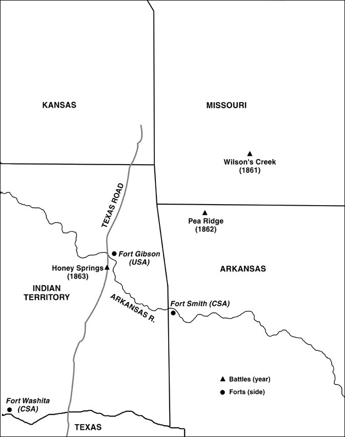
Table 2: Military units involved in the Battle of Honey Springs.
|
United States Army: |
|
Confederate States Army: |
Note: A company at full strength had approximately 100 men; a regiment was 10 companies.
Questions for Illustration 1 & Table 2
1. Examine Illustration 1. What major routes for transportation are near Honey Springs?
2. What advantage does the illustration suggest the United States Army might have over the Confederate States Army because the battle took place at Honey Springs?
3. Now study Table 2. How many Native American tribes are represented on each side? How many tribes have people fighting on both sides?
4. Refer back to your answer for Locating the Site, Question 4. Compare your answer to Table 2. How accurate were you in determining which Native Americans might be more sympathetic to the Confederate States versus the United States? Based on what you have learned in your readings and from Table 2, explain the representation of Native American tribes for each side.
Visual Evidence
Illustration 2: Location of the Battle of Honey Springs.
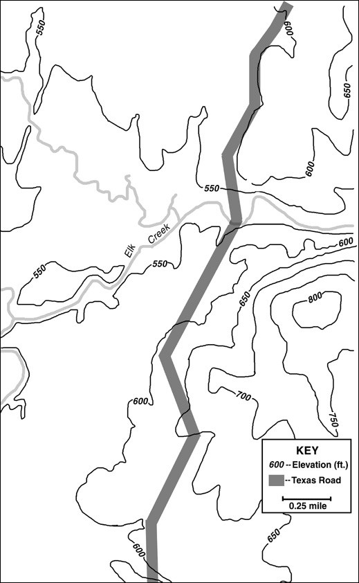
The accounts of the two commanders make it somewhat difficult to understand what happened during the battle. Before you start the exercises below, take a minute to become familiar with the area. The lines curving across the battlefield are contour lines; they are a way to represent changes in elevation on a two-dimensional surface like a map. Each line marks a change of 50 feet; the numbers refer to the distance above sea level.
Questions for Illustration 2
1. Virtually all the fighting in the Battle of Honey Springs took place in the area shown by this map. How large, in square miles, is this area?
2. Where is the highest point on the map? What is its approximate elevation?
3. The Texas Road was not a paved route, but a wide path worn into the plains. Why was the route it followed a good one for cattle and wagons?
4. Use Reading 3 to help you mark the course of the battle. On Illustration 2, write AUSA and ACSA to identify the approximate position of each side's troops as they readied for battle. (Locate the Confederate troops, then determine which ridge to the North the Union could have rested behind. Remember that both commanders were estimating, not measuring, distances.)
5. Mark on the map two of the spots where significant fighting occurred. Do not include the skirmishing mentioned at the beginning of Cooper's account. Identify the earlier one "A1," the latter "A2."
6. Mark the place where fighting ended "AE," where the Union troops stopped their pursuit of the Confederates. Look in Blunt's account of the battle to find this description.
Visual Evidence
Illustration 3: The Battle of Honey Springs.
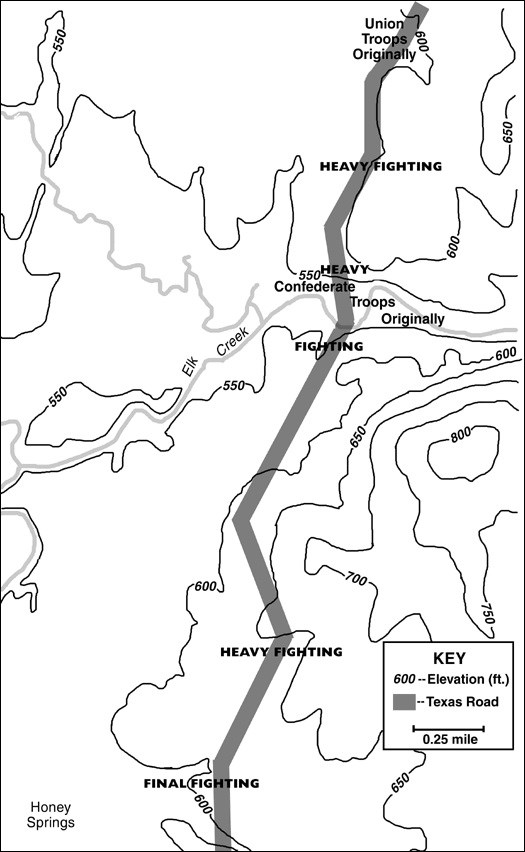
Questions for Illustration 3
1. Illustration 3 shows the course of battle as reconstructed through archeological evidence. Compare this version of the fighting with what you created on Illustration 2. How accurate was your illustration? Was it difficult to plot what happened based on the written account provided? Why or why not?
2. How difficult do you think it would be to recreate a battle based on archeological evidence? What are the pros and cons of doing so?
Visual Evidence
Drawing 1: The Battle of Honey Springs.

Caption: The war in Kansas, the Battle of Honey Springs, July 17--Defeat of the rebels under General Cooper by the U.S. Troops under Major-General James G. Blunt. From a sketch by James R. O'Neill.
Questions for Drawing 1
1. Examine the sketch, which appeared in the newspaper on August 29, 1863. It portrays Union cavalry attacking Confederate artillery and infantry positions. What different weapons appear to be used by the two armies?
2. Which side appears to be winning? On what do you base your opinion?
3. Compare this version of the battle with General Blunt's. How accurate does the picture seem to be?
Putting It All Together
The following activities will help students better understand some of the complicated conflicts illustrated by the Civil War in Indian Territory.
Activity 1: "What shall we do?"
Divide students into four groups. Assign each group to study one of the following tribes that receive less attention in the readings: Choctaw, Chickasaw, Creek, and Seminole. Have each group research their assigned tribe's decision to align itself with the Confederate States. In their groups, students should discuss the following questions: What goals did that tribe's leaders have? What options did they have? What were potential outcomes of each option? Considering the leaders’ goals and the options that were available, why do students think that their assigned tribe's leaders decided as they did? Have each group of students present their findings to the class.
Activity 2: The Great Equalizer
The commanding officers of both Union and Confederate forces at the Battle of Honey Springs praised the bravery and discipline of their African American and Indian units in their official reports on the battle, whatever their personal feelings might have been. Ask students to investigate how soldiers' conduct in other battles has affected racial attitudes. Assign a short essay using library research on the topic of how one of the following groups has participated in American wars: African Americans, Native Americans, Hispanic Americans, or Asian Americans. In their essays students should note in particular what role their group played in the military at the start of each war, how and why that role changed over the course of the war, and what military leaders thought of these soldiers by the end of the war. The essays should also include the reasons why members of the group they selected wanted to be part of the military.
Activity 3: Working Together Across Ethnic Lines
After reading this lesson and participating in the other activities students will have ascertained that during the Battle of Honey Springs African-American, American-Indian, and European-American soldiers fought together for the Union. Ask students to consider their own communities and whether or not there are examples in which distinct racial, ethnic, or cultural groups previously at odds banded together to meet a common goal. Ask students how successful were these occurrences, what issue was involved, and why the different groups joined together. After this classroom discussion, assign a skit or a written or oral report where students use library research and visits to their local historical society or cultural center to further study and learn about their example of different ethnic groups joining in order to reach a common goal.
The Battle of Honey Springs: The Civil War Comes to Indian Territory--
Supplementary Resources
By looking at The Battle of Honey Springs: The Civil War Comes to Indian Territory, students learn how the Civil War created fierce conflicts among American-Indian nations who had been moved across the Mississippi River. Those interested in learning more will find that the Internet offers a variety of interesting materials.
Battle of Honey Springs, Historic Site
Visit the Battle of Honey Springs' web pages to learn more about the battle and the Civil War in Indian Territory.
Library of Congress
The Library of Congress created a selected Civil War photographic history in their "American Memory" collection. Included on the site is a photographic time line of the Civil War covering major events for each year of the war.
Muscogee (Creek) Nation
The Muscogee (Creek) Nation Web page offers a look at how one faction of this tribe operates as a Nation today. The site details information on their history, present-day government structure, tribal affairs, customs, and more.
First Kansas Colored Infantry
Search the Kansas State Historical Society web pages for a detailed history of the First Kansas Colored Infantry at Honey Springs and other battles. Also featured is their regimental flag and its history.
Tags
- civil war
- civil war history
- native american history
- native american
- oklahoma
- oklahoma history
- cherokee nation
- cherokee history
- arkansas
- arkansas history
- national register of historic places
- nrhp listing
- teaching with historic places
- twhp
- battle of honey springs
- battlefield
- african american history
- military wartime history
- mid 19th century
- military history
- twhplp
- cwr aah
