Vegetation maps provide enormous amounts of data on plant species abundance and distribution, as well as associated data on topography and environment, in formats that readily inform planning decisions, assist research projects, and improve resource management.
After initial data collection and the creation of baseline maps, long-term monitoring of vegetation communities will help park managers and researchers better understand the dynamic nature of ecosystems and the processes that control them. Completed vegetation maps are currently being put to use in national parks around the country, in many of the ways discussed below.
Research
Vegetation maps are proving to be a valuable tool in ecological and resource management research. In the monitoring phase of the National Park Service (NPS) Inventory & Monitoring (I&M) Program, networks have developed plans to monitor various aspects of the environment to assist NPS staff to understand ecosystem processes and develop appropriate management plans for park units. For the Southern Colorado Plateau Network (SCPN), vegetation maps and the data associated with them played a role in the development of monitoring plans and protocols for upland vegetation at Aztec Ruins National Monument, and Mesa Verde and Petrified Forest national parks (Thomas et al. 2006). The vegetation map completed for Theodore Roosevelt National Park, North Dakota, is contributing to advanced remote sensing research for mapping an exotic, invasive plant species. A team of scientists from the NPS, USGS, and the University of California, Davis, have been analyzing NASA AVIRIS (Airborne Visible and Infrared Imaging Spectrometer) imagery to study the feasibility of detecting and mapping leafy spurge (Euphorbia esula) in and adjacent to the park. The recently completed vegetation map has proven extremely useful in this research.

from Thomas et al. 2009
Fire Management
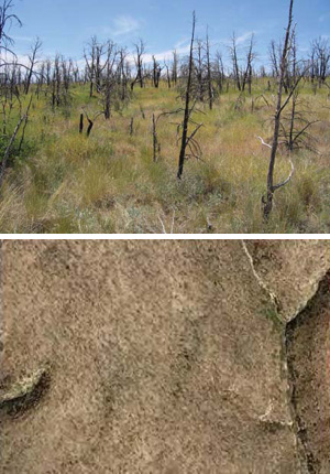
Fire management includes both prescribed and wildfire management. Prescribed fires are conducted for several reasons, including fuel reduction to promote human safety and encourage ecological processes. Vegetation mapping data are included in many park fire management models to optimize the use of funds and staff, prioritize areas for prescribed fire, and better predict wildfire and prescribed fire behavior. Vegetation map data are being used in fire management at Zion NP, Utah, and Walnut Canyon NM, Arizona. At Mesa Verde NP, Colorado, the vegetation map was used to develop a more detailed map of herbaceous vegetation that grew up in areas of the park that were burned in recent years (Hanna et al. 2008; see images at right); this more detailed mapping will help park staff to predict the outcome of different management practices in burned areas.
Planning
The maintenance and planning of park facilities can be facilitated using data from vegetation maps. For example, park staff can overlay existing trail systems on the vegetation map to analyze the percentage of trails in various vegetation types. This information can be included in the decision-making process for determining the closure of existing trails and/or reopening of former trail sections. Such an analysis, without the vegetation maps, would require park staff to hike entire trail systems and make extensive written observations. Managers at Acadia National Park, in Maine, have used their vegetation map for such trail management and planning.
Natural Resource Management
Vegetation maps can also be used in managing and controlling exotic species of animals and plants. For example, nutria (Myocastor coypus) can prove to be a major problem wherever they invade. They disturb the root mat of marsh plants while swimming and foraging, which kills marsh plants and can severely impact salt marsh habitat. In Assateague Island National Seashore, Virginia, vegetation mapping data has been used to create a potential nutria habitat map for use in eradication efforts.
Prepared by Ben Gillock, Patty Valentine-Darby, and Anne Cully, 2009.
Part of a series of articles titled Vegetation Mapping in the American Southwest.
Last updated: August 5, 2015
