Last updated: August 30, 2017
Article
Soil Organic Carbon Stocks in Mount Rainier National Park

Importance:
In light of changing concentrations of atmospheric carbon associated with increasing greenhouse gases, it has become increasingly important to understand the various carbon pools (live vegetation, dead vegetation, soils, etc.) in terrestrial ecosystems and their role in the overall carbon cycle. Soil organic carbon (SOC) is estimated to be the largest terrestrial pool of carbon and is one of the least understood. The soils of Mount Rainier National Park are distributed across a topographically and climactically diverse landscape, making the Park an ideal location for observing how these factors influence soil organic carbon concentrations. This study used GIS to pinpoint sites (n=8) within Mount Rainier National Park where the factors responsible for soil development were expected to be categorically unique. Four pits per site were excavated, characterized, and sampled by horizon. Additional samples were taken from surface horizons to capture the sub-plot spatial variation. Standard forest measurements of overstory, understory and woody debris were collected to act as predictors for SOC. Our study intends to quantify the importance of some of the factors influencing the spatial and vertical distribution of SOC in complex terrain, such as that of Mount Rainier National Park.
Status:
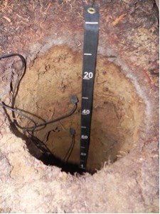
A total of 33 plots have been characterized, excavated and sampled. Each plot consists of one overstory vegetation plot, four understory vegetation plots, three transects assessing coarse woody debris, one primary soil sampling pit, and three secondary soil sampling pits. An archaeologist and soil scientist worked side-by-side, making sure that no archeological artifacts were disturbed during the soil sampling process. Approximately 10 ounces of soil were removed from each horizon (morphologically distinct layer) of the soil profile for further laboratory analysis. Soil moisture and temperature sensors were installed in 8 pits, providing climactic data useful in determining site characteristics and properties influencing soil development.
Discussion:
Sampling locations were carefully selected for their proximity to managed forest stands with site characteristics similar to those sampled within Mount Rainier National Park. Sampling these matched sites will provide future insight into the impact of management decisions on SOC. Special efforts were taken to establish these sites for long-term monitoring to determine the rate of sequestration or loss of SOC in high mountain ecosystems like Mount Rainier National Park.
