Last updated: July 29, 2022
Article
Climate and Water Monitoring at Organ Pipe Cactus National Monument, Water Year 2018
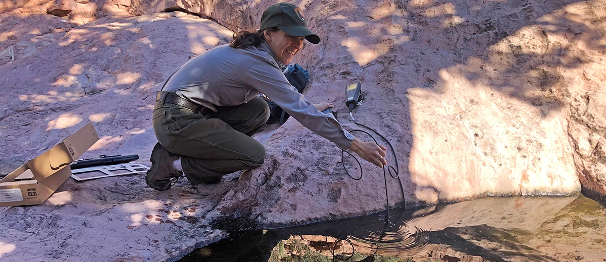
Climate, groundwater, and surface water are closely related. At Organ Pipe Cactus National Monument, the Sonoran Desert Network monitors all three to track broad-scale change and provide early warning of potential problems.
Background
Organ Pipe Cactus National Monument is one of the most biologically diverse protected areas in the Sonoran Desert, providing habitat for a wide variety of desert-adapted plants and animals, including numerous threatened and endangered species. The monument has been recognized as a globally important biosphere reserve, representative of the natural Sonoran Desert ecosystem. The cultural resources found within its boundaries reflect the long, widespread, and varied presence of diverse human groups, including those of Native American, Mexican, and Anglo origin.
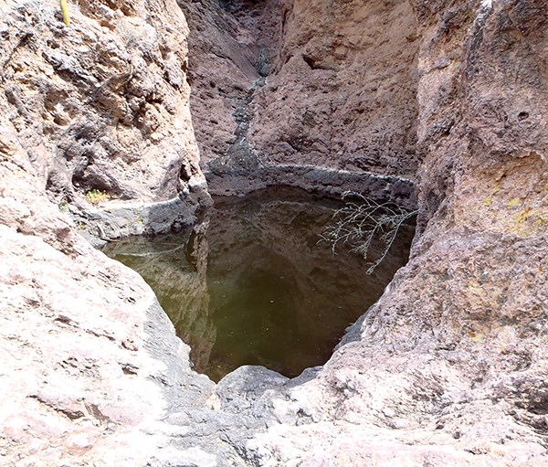
Tinajas represent most of the key surface-water features of Organ Pipe Cactus National Monument. In addition, three spring complexes—Quitobaquito, Bull Pasture, and Dripping Springs—are perennial, groundwater-driven systems. Collectively, these scattered water bodies represent important and isolated aquatic habitats within the park, providing important ecosystem services for the larger terrestrial landscape. The Sonoran Desert Network (SODN) monitors water quality, quantity, and ecological characteristics at four of these sites. The goal of the program is to detect broad-scale changes in ecological condition by observing certain parameters over time—and to give park managers early warning of any issues they may need to address. Park staff and cooperators have collected groundwater data since 1977, providing a long-term record for this important resource.
Hydrologic conditions are closely related to climate conditions. Because the two are better understood together, the Sonoran Desert Network reports on climate in conjunction with water resources. Reporting is done by water year (WY), which begins in October and ends the following September.
Recent Findings (Water Year 2018)
Climate
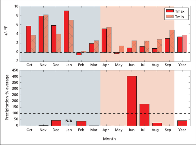
Water year 2018 was drier than normal. Overall annual precipitation was 44% of normal, based on a 30-year record (1981–2010). The cool season (October–March) was particularly dry, receiving just 18% (-4.07") of normal precipitation. A majority of the rainfall occurred in July. All other months, with the exception of June, had 0–45% of normal precipitation. Temperatures tended to be warmer than normal, and there were fewer extremely cold days. The reconnaissance drought index indicated that the regional drought that began in 2000 continued through WY2018. Additional information can be found at climateanalyzer.org.
Groundwater
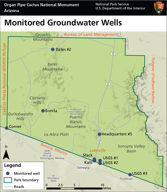
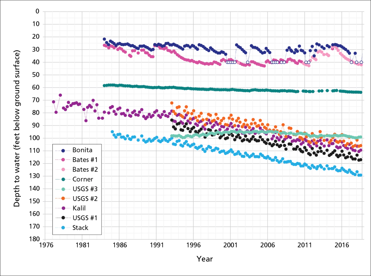
Nine groundwater wells were monitored in WY2018. Water levels declined (-0.18 to -1.70 feet) from WY2017 levels at all of those wells. The lowest recorded water levels at six of the wells occurred in WY2018 (a seventh was dry). Six wells show a general downward trend over the monitoring record: Headquarters #5, Kalil, Stack, USGS #1, USGS #2, and Corner. Except for Corner Well, all of those wells are experiencing similar rates of decline, in part due to seasonal groundwater pumping to support agriculture south of the U.S.–Mexico border. The monitoring records at the Bates #2, Bonita, and USGS #3 wells have been more variable, indicating localized factors impacting groundwater levels across the park.
Springs
The Sonoran Desert Network monitors water quantity, water quality, and site condition at four springs and tinajas at Organ Pipe Cactus NM. Dripping Springs and Quitobaquito Spring were wetted throughout WY2018. Sensor displacement prevented collection of reliable data on water quantity at the other two monitored springs. Water-quality measurements fell within the expected range for all springs. Dripping Springs, East Arroyo Tinaja, and Snake Pit Tinaja were classified as undisturbed for both anthropogenic and natural disturbance. Quitobaquito Spring showed slight anthropogenic disturbance from various efforts by park staff to promote flow to Quitobaquito Pond. Water levels are a long-standing concern at the pond, which is designated critical habitat for the endangered Quitobaquito pupfish (Cyprinodon eremus). The pond also provides habitat and water for the endangered Sonoyta mud turtle (Kinosternon sonoriense longifemorale) and a wide array of other plant and animal species, as well as important ecosystem services for the larger terrestrial landscape. For more information on the ecological importance of Quitobaquito Pond, download the monument’s State of the Park report.
Information in this brief was summarized from K. Raymond, L. Palacios, C. McIntyre, and E. L. Gwilliam. 2019. Status of climate and water resources at Organ Pipe Cactus National Monument: Water year 2018 and the monument’s State of the Park report.
