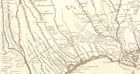
The early trade routes established by the Caddo later supported European settlement as well as economic and political growth in Texas and Louisiana for over 300 years. When Europeans first arrived in Caddo territory, they found well-traversed trails connecting native cultural settlements. The Spanish built missions and posts along the main thoroughfares, which collectively became known as El Camino Real de los Tejas or the Royal Road to the Tejas.
-
El Camino Real de los Tejas National Historic Trail
Article 1: Caddo Nation- The Sacred Landscape
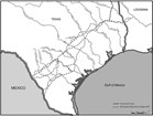
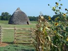
Long before Europeans came to explore Texas, the people now known as Caddo had a well-developed trail system across their territory in East Texas. Major east-west and north-south trails led to and from important mound centers and established communities where significant social, political, and religious rituals and traditions, along with daily domestic activities, occurred. Read more
-
El Camino Real de los Tejas National Historic Trail
Article 2: Early Caddo History
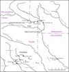
The Caddo originated in the lower Mississippi Valley and spread west along the river systems. Sometime between 700 and 800 they settled the area between the Arkansas River and the middle reaches of the Red, Sabine, Angelina, and Neches rivers and adopted agriculture. They grew corn and pumpkins as primary crops which, later combined with beans and squash, stimulated population growth. Read more
-
El Camino Real de los Tejas National Historic Trail
Article 3: Caddo Social Structure
The Caddo people trace their descent through the maternal line. They recognized and ranked clans, with marriage typically occurring between members of different clans. Religious and political authority in historic Caddo communities rested in a hierarchy of key positions shared between the various affiliated communities. Read more
-
El Camino Real de los Tejas National Historic Trail
Article 4: Caddo Trade

Located where the southeastern woodlands meet the western prairies, the Caddo produced bountiful crops and were well placed to participate in exchange networks. Key trails fanning out as far afield as Florida; Casas Grandes, Arizona; Cahokia, Illinois; and the Rio Grande pueblos of New Mexico crossed Caddo country, linking the Caddo to distant Indian worlds and positioning them at a crossroads of trade. Read more
-
El Camino Real de los Tejas National Historic Trail
Article 5: Caddo Population Decline
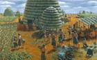
Over the course of more than 500 years, the Caddo developed powerful political chiefdoms, organized complex ranked societies, erected ceremonial centers and temple mounds, and participated in long-distance exchange networks. At their height, around 1300, they may have numbered more than 200,000 people. Read more
-
El Camino Real de los Tejas National Historic Trail
Article 6: Caddo Timeline
This timeline describes the European influence and interaction with the Caddo people, from the mid-1500's to the mid-1800's. Beginning in the early 1820s, increased Anglo migration into Caddo territory (“land grabs”) impacted the sacred Caddo landscape significantly. Read more about the impacts of the Anglo influence on the Caddo Nation over time. Read more
-
El Camino Real de los Tejas National Historic Trail
Article 7: Well-Traversed Caddo Trails

The early trade routes established by the Caddo later supported European settlement as well as economic and political growth in Texas and Louisiana for over 300 years. When Europeans first arrived in Caddo territory, they found well-traversed trails connecting native cultural settlements. The Spanish built missions and posts along the main thoroughfares, which collectively became known as El Camino Real de los Tejas or the Royal Road to the Tejas. Read more