Last updated: September 25, 2024
Article
Prehistoric Landscapes of the Nation's Capital
Introduction
NPS
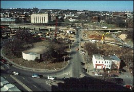
In 1996 and 1997, Parsons Engineering Science conducted archeological excavations of the Whitehurst Freeway Corridor for the DC Department of Public Works. The project was done under an Archaeological Resources Protection Act (ARPA) permit issued by the National Park Service. Excavations at the eastern end of the roadway, near the location where Rock Creek drains into the Potomac River, yielded both prehistoric and historic archeological resources.
Several archeological sites were identified as a result of this work including the Peter House and Whitehurst West sites. These sites offered archeologists a number of excavation challenges. For a brief discussion on how these hurdles were overcome, see the Excavating the Whitehurst Freeway Sites section below.
The Peter House
NPS
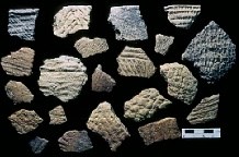
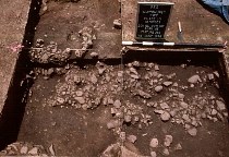
Foundations from 18th and 19th century houses were built directly over intact prehistoric deposits. The gully ran beneath the sidewalk north of the houses. During late prehistory, the drainage was filled. It contained stratified, charcoal-rich deposits with large amounts of fire-cracked rock, flaking debris from stone tool making, and broken pieces of pottery, or sherds, in sufficient numbers to indicate that the surface had been stable and open for an extended period of time.
NPS
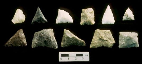
Artifacts ranged in date from Middle Archaic projectile points (6500-3000 B.C.) to Late Woodland points and ceramics (900-1600 A.D.), with the Middle and Late Woodland periods most frequently represented (about 500 B.C. to 1600 A.D.). Over time, a series of deposits was formed through a combination of trash dumping from a large site located upslope and other activities. Two intact hearths, dating to the early Late Woodland period, contained fire-cracked rock and sherds. Charred organic materials found on the inner surfaces of some sherds were dated to around 1100 A.D.
Plant remains from one of the features included bedstraw, pokeweed, and wild grape, all with known prehistoric food and medicinal uses. Dates on samples from the surrounding deposit ranged from 970 to 1090 A.D. Dates from the lowest levels of the deposit ranged from 260 B.C. to 180 A.D., which convincingly places the main occupations within the Middle to early Late Woodland periods.
Whitehurst West
The Whitehurst West site lay on a terrace adjacent to Rock Creek, west of the Rock Creek Parkway. It is now about 45 meters (148 ft) east of the stream bank and 2 meters (7 ft) above high tide.
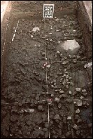
The lowest level is a natural gravel bar lying on Ice Age river deposits. This level may have been exposed during the latter part of the Late Archaic, as evidenced by a radiocarbon date of 2650 B.C. Later, the surface was open and occupied in the middle of the Woodland period, based upon the ceramics and stone artifacts found with fire-cracked rock, cobbles, charcoal, and gravel. This thick deposit was named Feature 502.
NPS
Radiocarbon dates taken from charcoal samples and residues adhering to sherds from Feature 502 ranged from 770 to 990 A.D. Dates for the deposit overlying Feature 502 ranged from 1210 to 1260 A.D. The uppermost layer dated to 1640 A.D. More than 4.25 meters (14 ft) of historic fill overlaid the prehistoric deposits in this location.
NPS
The presence and distribution of artifacts and animal bone in this feature suggested that the spatial arrangement of the deposit had been preserved to some degree. Many small pieces of burned animal bone were recovered, along with plant remains from pokeweed, hickory nut, walnut, raspberry, and blackberry. Organic remains adhering to some sherds provided evidence of the processing of grass seed and a tuber related to the potato.
Conclusions
The Whitehurst sites, located near the confluence of Rock Creek and the Potomac River, are in a prime location below the Great Falls of the Potomac. The fall line was important to prehistoric peoples for three reasons: (1) it was a point of contact between different groups or cultures; (2) it was a point where people could control access to critical seasonal resources; and, (3) it was a point of constriction where people could control a regional trade artery.
During the late winter and early spring anadromous fish, like herring, leave the salt water of the Atlantic Ocean and Chesapeake Bay to spawn in fresh water. The late winter and early spring fish runs below the Great Falls of the Potomac provided the area's Woodland populations with an ample source of protein during the leanest months of the year. Deposits dating to 970 to 1090 A.D., at the Peter House site, point to a large settlement upslope on the high terrace. At Whitehurst West, Feature 502 may represent the refuse from an early Late Woodland village strategically located to take advantage of the fish runs.
Excavating the Whitehurst Freeway Sites – Challenges
NPS
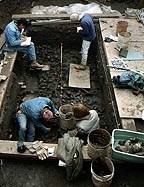
Archeological testing in the Whitehurst Freeway Corridor revealed that intact archeological resources were buried beneath anywhere from 3 to 17 feet of historic fill. Filling along the banks of Rock Creek began as early as the first quarter of the nineteenth century when the excavation of the Chesapeake and Ohio Canal resulted in the availability of fill that was used to reclaim swampy areas near the confluence of Rock Creek and the Potomac River. For example, the nearby Watergate Hotel is located on ground that would have been mudflats in the eighteenth century. The filling continued throughout the nineteenth and into the twentieth century.
The area closest to K Street near the Peter House site was capped with the least fill, measuring less than 3 feet in depth. As the ground sloped down toward Rock Creek, the depth of fill increased, with 14 feet of fill over Feature 502 at Whitehurst West. In order to remove the fill to reach undisturbed archeological features and layers, a backhoe was used. Upon encountering intact archeological deposits, hand excavation began.
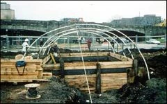
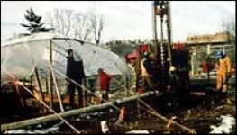
Archeological excavations complied with OSHA safety standards, either utilizing a 1.5:1 slope or employing benching or shoring. Whitehurst West, located closest to Rock Creek, was excavated in the winter of 1996-1997. Water problems were encountered because of the proximity to Rock Creek and the wetness of the season. Well points were drilled to allow for excavation by lowering the water table. Because of the depth of the excavation (14 feet below ground surface) and limitations in expanding the trench, due to the proximity to the Rock Creek Parkway and a jogging path, shoring was constructed to assure safety. A shelter was built over the excavations to protect the archeologists from the cold and allow research to continue in sub-freezing temperatures.
NPS
NPS
Our web content is changing as park staff work with Tribal representatives to review the exhibit of cultural items to ensure that the voices and perspectives of associated Tribes are appropriately included.
