Tsunami in American Samoa
Tsunamis are nothing to take lightly, especially when one is coming your way. These acts of nature are caused by strong earthquakes on the sea floor that results in shock waves that are sent out in all directions from the epicenter. If the earthquake is small, little to no waves are caused. But if a major earthquake occurs, then a major tsunami event is sure to be the result.
On September 29, 2009, the people of American Samoa experienced a magnitude 8.1 earthquake that occurred 120 miles south-southwest from American Samoa, about 13 kilometers below the sea floor. For most residents living inland, the major earthquake was a bizarre occurrence that didn’t generate as much concern as it should have. But for the thousands of people who reside in and around the coastal areas, they were about to experience something unimaginable.
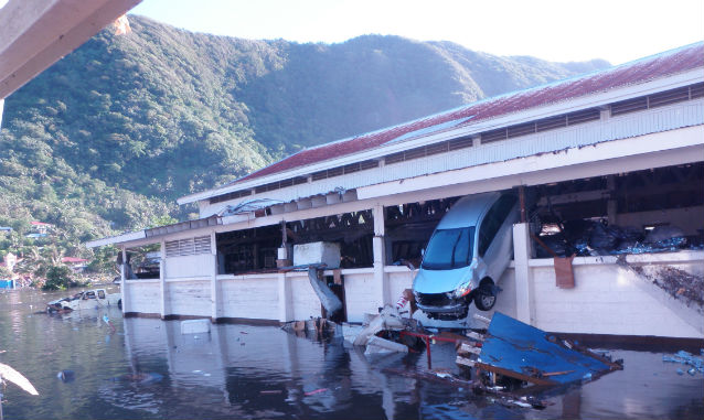
After the earthquake, villagers could see the ocean receding which was a tell-tale sign that something was wrong. Fifteen minutes later, multiple waves ranging in height from 15 to 20 feet struck certain coastal areas in American Samoa.
The National Park of American Samoa’s visitor center and office in Pago Pago village were completely destroyed by the oncoming waves. One park volunteer was injured when her car was overturned by the waves while she was driving. The rest of the park staff were safe, however, one park volunteer lost his home and the cars of others were inundated.
Although the devastation claimed the lives of 34 individuals that day, the people of American Samoa were quick to provide assistance to those who had been severely affected by the tsunami. The National Park of American Samoa’s staff, led by former Superintendent Mike Reynolds, helped with search and rescue efforts in hard-hit villages and provided assistance to villagers with debris removal and cleanup efforts. National park staff put aside their own grief and worries to aid those who were in need.
Local villagers were completely caught off guard because tsunamis hadn't been a natural occurrence in American Samoa for as long as anyone could remember. To ensure that island residents are prepared for future tsunamis, the American Samoa Government received financial assistance to setup a siren system throughout Tutuila Island to warn residents of possible tsunami threats. Villagers and park staff still remember the 2009 tsunami. This tragic event has served to strengthen the island community so that everyone knows more about tsunamis and to be prepared for the next one.
Earthquakes and Tsunamis in the Pacific Northwest
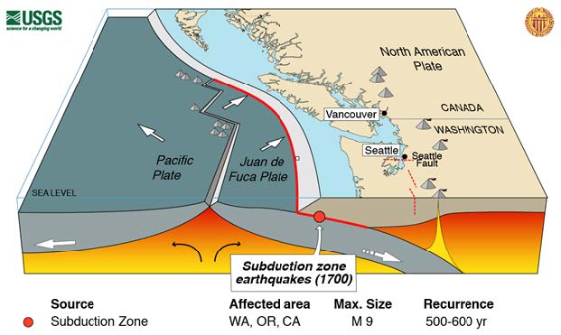
The same geological forces that form the spectacular coastline of the Pacific Northwest also threaten lives and infrastructure with earthquakes and tsunami. However, with preparation, the loss from these inevitable events can be significantly reduced. Our understanding of the hazard has evolved over the last several decades. It was not until the 1990’s that scientists realized the Cascadia Subduction Zone off the coast of the Pacific Northwest had produced Magnitude 9 earthquakes and generated tsunami large enough to devastate coastal Native American communities and cause deaths and damage in Japan. Cascadia earthquakes and tsunami can be similar in size to those experienced recently in Sumatra, Indonesia (2004) and Honshu, Japan (2011).
Off the coast of western North American from northern California to southern British Columbia, the Juan de Fuca Plate slides (or "subducts") underneath the North American Plate. Native American oral traditions have long included accounts of an active earth that shook and flooding that "put canoes in the trees," but for years, these stories were not widely appreciated. The history of how scientists and the wider community came to understand this earthquake threat and to pinpoint the most recent massive earthquake on January 26, 1700 at 9 pm local time starts, surprisingly, with stands of dead trees. While US Geological Survey researchers were studying coastal Washington State, they found stands of dead cedar trees and groups of spruce trunks near the coast. What had killed them? Clues came from sediment layers around the trees. These showed a 3-layer sequence with forest floor soil (when the trees had been alive and flourishing) on the bottom, a layer of sand in the middle, and tidal muds on top. What accounts for this sequence? Between major subduction zone earthquakes, the down-going plate pushes against the over-riding plate, causing coastal land to gradually rise as much as ten feet.
Image adapted from USGS.
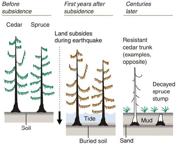
During an earthquake, the land suddenly drops back down. If a tsunami is also generated, it covers some coastal areas with sand. Finally, tidal mud deposits upon the newly lowered land and the trees die from salt incursion.
This evidence showed that large earthquakes and local tsunami occurred. But did earthquakes rupture the entire length of the subduction zone at one time or did shorter sections of the coast move in smaller earthquakes? A combination of carbon-14 dating, tree ring analysis, and Japanese records describing an “orphan” tsunami that arrived without local ground shaking but still caused scores of drowning deaths, allowed the timing of the 1700 earthquake to be precisely determined. It also demonstrated that a massive Magnitude 9 earthquake ruptured the entire length of Cascadia. Modern measurements using high-precision GPS confirm the region continues to be compressed and that another massive earthquake and tsunami will inevitably occur. However, the risk to our communities from this threat can be greatly reduced by careful preparation. We can improve escape routes, harden key infrastructure, build vertical evacuation structures, and above all, educate residents to “run to high ground” as soon as earthquake shaking stops.
Tree image adapted from “Orphan Tsunami of 1700” by Brian Atwater and others. Available online.
Increasing Earthquake and Tsunami Resilience by Reaching Educators
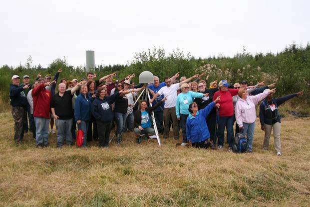
Courtesy Robert Lillie
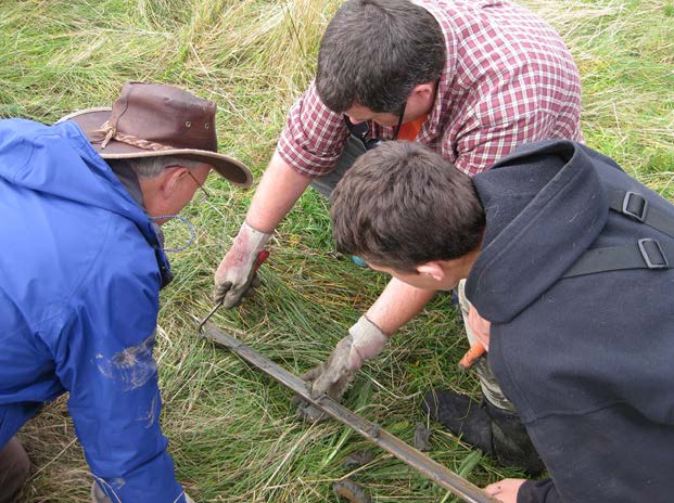
Tens of thousands of California, Oregon, and Washington residents live within severe earthquake shaking and tsunami inundation zones, and millions of tourists visit state and federal parks in these same areas each year. These communities are not yet ready to respond effectively to the earthquake-tsunami events that originate from the Cascadia Subduction Zone. We know that events similar to the Japan 2011 earthquake and tsunami, where 20,000 people were killed, have and will happen in the Pacific Northwest. One effective and efficient way to reach more coastal community members is to equip educators with the knowledge and tools to teach the science and preparedness of earthquakes and tsunami. Through a grant from the EarthScope Program of the Increasing earthquake and tsunami resilience National Science Foundation, Cascadia EarthScope Earthquake and Tsunami Education Program (CEETEP) is working to increase resilience in coastal communities of the Pacific Northwest. CEETEP offers four-day workshops for educators – teachers, park/museum interpreters, and emergency management educators. Through interactive lectures, field trips, and action team activities, participants learn about the geological evidence, ongoing scientific research, and community preparedness actions for earthquake and tsunami in the Cascade coast region of North America. By bringing together different types of educators, CEETEP helps to foster collaboration within the communities so that educators are more likely to follow through on plans and deliver consistent emergency preparedness messages across learning venues. Behavioral research shows that a consistent message repeated by a variety of trusted sources produces the most change.
CEETEP is currently completing its second of three program years. Workshops have been held in Newport and Astoria, OR and Aberdeen and Forks, WA. There will be one in Coos Bay, OR in August and in Arcata, CA in October of 2015. In total, more than 150 educators will be reached. Each year in the spring following the primary workshops, participants from two workshops come together in a Share-a-thon to present what they have done and discuss ideas for further work. Survey results of workshop participants show that they make significant gains in content knowledge and confidence in teaching about geohazards and preparedness, take preparedness steps themselves, and are much more optimistic about the efficacy of community-level action.
Examples of successful projects include: 1) a team from Astoria, OR which worked collectively to sponsor the Columbia River Maritime Museum’s December 2013 Community Day focused largely on earthquake and tsunami science and preparedness; the event reached hundreds of community members and involved more than a dozen Astoria High School students as docents; 2) teachers from southern Washington galvanized middle school students to hold school and community preparedness assemblies and, in collaboration with Southern California Earthquake Center, arranged to have sixteen seismometers installed in public and educational facilities so that learners could participate in ongoing geoscience research; and 3) a 5th grade class conducted a tsunami geology coring investigation and hazards assessment project that received the Samsung Solve Prize for Oregon – $20,000 in Samsung equipment for the school.
Contributors
Courtesy Beth Pratt-Sitaula
Contributors:
Robert Butler, University of Portland
Nancee Hunter, Hatfield Marine Science Center
Robert Lillie, Oregon State University
Sam Meleisea, National Park of American Samoa
Beth Pratt-Sitaula, Central Washington University
Editor: John Dell'Osso, Point Reyes National Seashore
Part of a series of articles titled Pacific Ocean Education Team (POET) Newsletters.
Previous: POET Newsletter September 2014
Last updated: October 8, 2021
