The riparian areas in the two higher-elevation Cascades Range parks, Lassen Volcanic NP and Crater Lake NP, had over three times as many species as comparable upland plots.
Get PDF
Download PDF of this article
Note from author Sean B. Smith
Sadly, Dr. Daniel Sarr passed away shortly before publication of this article. Along with many other things, his enthusiasm for biodiversity will be greatly missed. When first presented with the observations reported here he became giddy with delight that so many plants were found in these riparian areas.
Abstract and key words
Abstract: We analyzed vascular plant species richness in 0.1 ha (0.25 acre) plots collected in probabilistic samples of upland and riparian systems of four National Park Service units, Crater Lake National Park (NP), Lassen Volcanic National Park (NP), Redwood National and State Parks (NSP), and Whiskeytown National Recreation Area (NRA), to compare patterns of vascular plant species diversity. We found that riparian plots were richer in species than upland environments in all four parks. Contrary to the typical global pattern of declining species richness with increasing elevation, we noted an increase in average richness of riparian plots from 0 to 2,382 m (7,815 ft) elevation, and a hyperdiversity of species in riparian plots at Crater Lake NP and Lassen Volcanic NP (riparian plots had over three times the mean species richness of upland plots). Higher-elevation riparian plots had a higher proportion of native herbaceous perennial species than lower-elevation riparian plots. The rich flora of moisture- and cold-adapted herbs in riparian areas of Crater Lake NP and Lassen Volcanic NP suggests that these montane riparian zones act as refugia for a rich pool of species that were likely more widespread in colder periods of the Pleistocene, and have since been preserved in these low-latitude refuges by distinct microclimatic and hydrologic conditions that limit warming and drying.
Key Words: Crater Lake National Park, high-elevation riparian, hyperdiversity, inventory and monitoring, Lassen Volcanic National Park, plant diversity, Redwood National and State Parks, refugia, riparian, Whiskeytown National Recreation Area
Glossary
Riparian: Those locations near a stream or river that are affected by hydrologic processes, or which disproportionately affect the stream through shading, litter fall, or other influences. Riparian areas may be entirely or partially wetlands, depending upon the hydrology, soils, and vegetation present.
Upland: Those locations away from streams, lakes, or other water bodies, where local climatic and geologic processes control vegetation, and characteristic wetland soils and plant species are absent.
Wetland: Those locations that typically have hydrology, soils, and vegetation that are indicative of saturation with water for substantial periods of the growing season.
WITHIN PARKS AND PROTECTED AREAS, as elsewhere, riparian areas often comprise a small portion of the total area, but a notable proportion of native plant diversity (Goebel et al. 2003). The drivers of riparian diversity span multiple scales, from local disturbances to broad-scale gradients in climate and geology (Baker 1989; Gregory et al. 1991; Bendix 1994; Sarr and Hibbs 2007).
In the United States, national parks and other protected areas are known to disproportionately represent high-elevation and lower-productivity terrain (Scott et al. 2001), and have been shown to be less biodiverse than private lands (Hansen and Rotella 2002). For vascular plants, species diversity typically declines sharply with increasing elevation (Glenn-Lewin 1977) or, in arid environments, shows a unimodal pattern with elevation, with maximum vascular plant diversity at middle elevations (Whittaker and Niering 1965). These empirical patterns suggest that high-elevation environments protect fewer species than comparable areas at low elevation. However, while many studies have focused on upland plant communities, not much is known about the patterns of riparian plant diversity across elevation gradients.
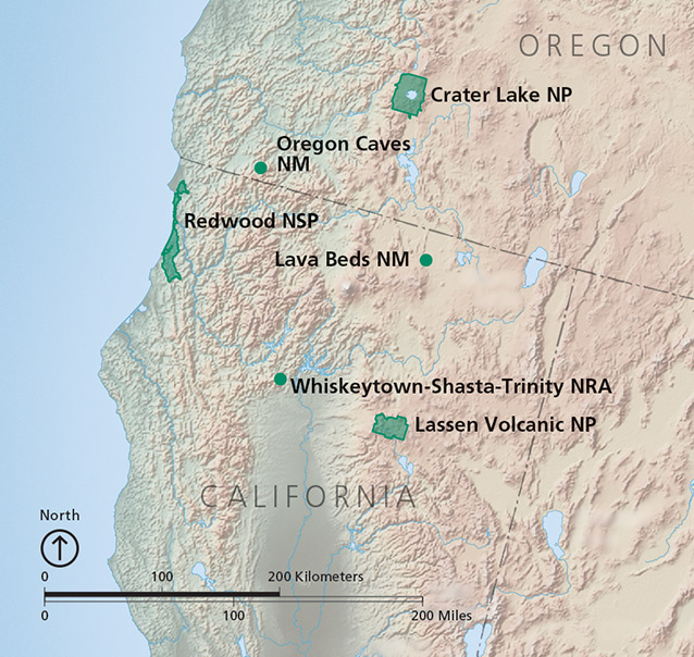
The Klamath Network, composed of six National Park Service units in southern Oregon and northern California (fig. 1), encompasses a rich array of plant communities, from maritime coastal forests to upper montane and alpine environments. Riparian areas span much of the gradient from sea level to the subalpine zone, allowing a comparison of elevation effects on upland and riparian diversity. In this study we compared the diversity of upland and riparian vegetation across an elevation gradient of approximately 0–2,382 m (0–7,815 ft) and spanning four parks of the Klamath Network, listed from lowest to highest average elevation: Redwood National and State Parks, Whiskeytown National Recreation Area, Crater Lake National Park, and Lassen Volcanic National Park.
Methods
We used data collected by the Klamath Network Inventory and Monitoring Program in four parks from 2011 to 2013. All data were collected using the Klamath Network Vegetation Monitoring Protocol (Odion et al. 2011). Full field methods are provided in the protocol. We present abbreviated methods here.
Site selection and fieldwork
In 2011, we sampled 26 upland and 21 riparian sites (elevation range 4–694 m [13–2,277 ft]) at Redwood NSP. Our 2012 effort resulted in 18 upland and 14 riparian sites (elevation range 1,798–2,382 m [5,899–7,815 ft]) at Lassen Volcanic NP, and 21 upland and 15 riparian sites (elevation range 288–1,313 m [945–4,308 ft]) at Whiskeytown NRA. In 2013, we sampled 26 upland and 20 riparian sites (elevation range 1,382–2,061 m [4,534–6,762 ft]) at Crater Lake NP. All plots were sampled in designated sampling frames, which were located in riparian or upland sites using a spatially balanced and probabilistic sampling design. For safety and accessibility, sites were excluded from areas more than 1.0 km (0.6 mi) from a road or trail. We also avoided steep slopes (>30°) and areas otherwise too dangerous for field crews to sample repeatedly (e.g., barren lava flows, talus slopes). With one exception, at Whiskeytown NRA, because of the dangers posed by the presence of illegal Cannabis cultivation gardens, all sites were sampled < 150 m (492 ft) from a road or trail. All riparian sites were located along perennial streams derived from the USGS National Hydrography Dataset (NHD).
Our plot design was adapted from methodologies of the Carolina Vegetation Survey (Peet et al. 1998) and uses a hierarchical nested Whittaker plot. For upland sites, we used a 20 × 50 m (66 × 164 ft) plot. For riparian sites, we attempted to establish one 10 × 50 m (33 × 164 ft) belt on each stream bank. If one of the stream banks was inaccessible, rather than reject the site we used a 10 × 100 m (33 × 328 ft) plot. Keeley and Fotheringham (2005) demonstrated that such variation in plot shape does not typically affect diversity studies if plot sizes are similar. All upland and riparian plots sample a total of 0.1 ha (0.25 acre). At each plot, all vascular plant species at a site were identified, environmental data and geographic coordinates were recorded, and unknown specimens were collected for later identification.
Data analysis
All data were collected and stored in a custom-made Microsoft Access database. More complex data analyses were performed with the R statistical package (R Core Team 2013). Scatterplots and regression analyses were performed in R using the ggplot2 package.
Results
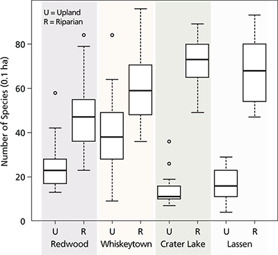
Here we analyze and report only species richness (number of vascular plant species) for all 0.1 ha (0.25 acre) plots. Across all parks mean species richness for riparian sites was 62 vascular plant species (± SD 17.8), while mean richness for upland sites was 23 (± SD 14.6). This difference was highly significant (analysis of variance F1,159 = 225.8, p < 0.001). Although riparian plots had higher species richness than upland plots at all parks, the magnitude of difference varied markedly across parks (fig. 2). In particular, the riparian areas in the two higher-elevation Cascades Range parks, Lassen Volcanic NP and Crater Lake NP, had over three times as many species as comparable upland plots. Nonnative species were observed more frequently at plots in the lower-elevation parks (34% at Redwood NSP and 83% at Whiskeytown NRA) than at the higher-elevation parks (34% at Lassen Volcanic NP, and 26% at Crater Lake NP). Viewed across all species recorded in our field sampling, percentages of nonnative species richness were much smaller at higher-elevation parks (0–6% at Lassen NP and 0–11% at Crater Lake NP versus 0–70% at Redwood NSP and 0–32% at Whiskeytown NRA).
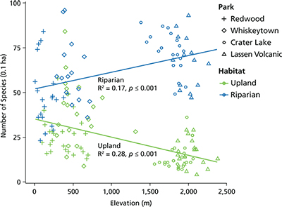
Scatterplots and univariate regression models of species richness against elevation showed opposing patterns for upland and riparian plots (fig. 3). Whereas species richness significantly declined with elevation in upland plots (F1,89 = 35.4, R² = 0.28, p < 0.001), it significantly increased (F1,68 = 14.8, R² = 0.17, p < 0.001) in riparian plots. Rather than showing declines in species richness with increasing elevation, as is recorded in most field studies of vascular plants in North America (Glenn-Lewin 1977), and in adjacent upland plots in the same parks, the high-elevation riparian plots were, in fact, hyperdiverse. It is important to emphasize that the hyperdiversity in high-elevation riparian areas that we recorded is composed primarily of native species; these samples had the lowest frequency and lowest cumulative richness of nonnative plant species.
Paradoxically, when analyzed separately for each park, plots showed minor and typically insignificant declines in species richness with increasing elevation, in both upland and riparian sampling frames (data not shown). Thus, the major divergence in diversity between upland and riparian areas appears to be manifested at landscape scales across multiple parks. The relationship between plot latitude and species richness, which is noted in most studies of vegetation (Sarr et al. 2005), was significant and negative for univariate regression models of upland plots (F1,89 = 15.8, R² = 0.15, p < 0.001), but not for riparian plots (F1,68 = 2.4, R² = 0.02, p = 0.12). This suggests that riparian areas of the Klamath Network parks are regionally decoupled from widely reported biogeographic patterns (i.e., that vascular plant diversity declines with elevation and latitude) (Sarr et al. 2005; Guo et al. 2013).
Because we sampled across three years, it is possible that climatic variation was associated with some of the landscape variation in diversity we recorded. Climate data for 2011 and 2012 were close to long-term climatic averages (PRISM Climate Group 2014), but 2013, when we sampled Crater Lake NP, was the start of a severe drought in the Klamath region. Upland plots for Crater Lake NP showed the lowest diversity of all plots, whereas riparian sites still had high richness (fig. 2), so the impacts of the drought on diversity are unclear.
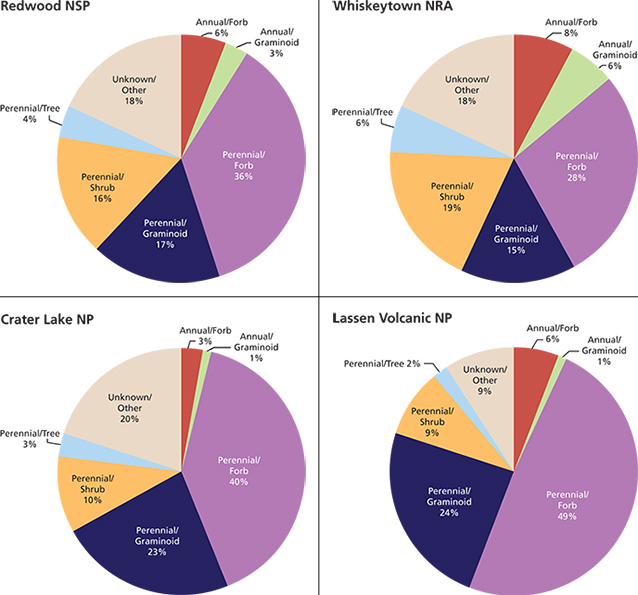
To better understand the nature of such high species richness in montane riparian zones, we partitioned the species into life history groups (i.e., annual or perennial and tree, shrub, forb, or graminoid) of all species as a percentage of overall flora we observed across the sample frame in each park (fig. 4). Because these aggregate data were not replicated and thus not tested for significance, we cannot make statistical inferences about overall species composition across comparable landscapes. Nevertheless these data illustrate the general floristic character of the high-elevation riparian communities we sampled. First, at riparian sites at the higher-elevation parks, Crater Lake NP and Lassen Volcanic NP, a higher percentage of the flora is perennial forbs and graminoids. Second, in low- and mid-elevation parks, Redwood NSP and Whiskeytown NRA, a higher percentage of the flora is woody species and annual forbs and graminoids.
Discussion
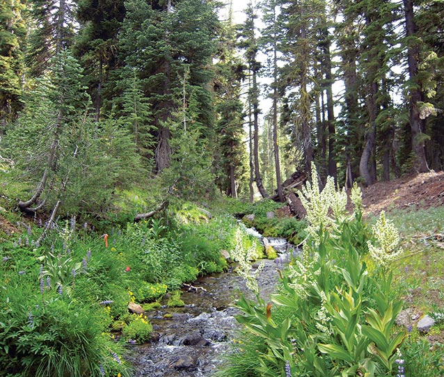
NPS Photo
Efforts to conserve biological diversity are always imperfect, as we lack the resources to protect all lands and to control all land uses. Geographic location is therefore highly important, and the search for biodiversity hotspots is a major goal of conservation planning (Scott et al. 2001; Myers et al. 2000). The high-elevation lands that make up most western park landscapes were carved from the most remote and typically least agriculturally productive parts of the landscape, and have usually been found to be poorer in species than lower-elevation environments for most native taxa studied (Scott et al. 2001; Hansen and Rotella 2002). This does not appear to be the case with vascular plants in riparian areas at Crater Lake NP and Lassen Volcanic NP. These high-elevation parks protect a very rich riparian flora that is also highly distinctive in the larger landscape. In particular, these riparian environments are hotspots for graminoids like sedges (Carex spp.), rushes and woodrushes (Juncus and Luzula spp.), and perennial grasses (Deschampsia, Glyceria, and Calamagrostis spp.), as well as a rich array of moisture-loving forbs (Senecio, Aconitum, and Viola spp.). The rich riparian flora of the higher-elevation parks is also made up predominantly of native species, more so than in the lower-elevation parks.
The presence of such moisture- and cold-adapted plant species in the quasi-Mediterranean climate of the Klamath region is known to be associated with unique microclimates, such as the well-known summer fog zone at Redwood NSP and environs (Barbour and Major 1977). This study suggests that high-elevation riparian areas, which occur above the winter snowline and are irrigated by snowmelt and groundwater flow through the warm, dry summers, sustain a rich pool of cool, temperate species that are, possibly, relicts from a cooler and wetter past. Our findings of divergent patterns in the relationships among elevation, latitude, possibly climate, and diversity in riparian and upland plots suggest riparian plant communities show unique biographic patterns and processes in our park landscapes.
Although the landscape settings of these riparian environments appear to contain a number of short-term stabilizing mechanisms (e.g., late-lying snows, abundant groundwater and soil moisture, and cool microclimates), their long-term vulnerability and viability are poorly understood. A fundamental driver of these systems appears to be winter snowpack, which delays runoff of winter precipitation and allows it to continually recharge groundwater reservoirs and feed perennial streams through the summer, which in turn harbor the rich, predominantly native riparian flora (fig. 5). Snowpacks in the mountains of northern California and southern Oregon are known to be highly sensitive to temperature, and projected changes in snowpack suggest that in future decades a larger proportion of precipitation may fall as winter rain (Mote 2006), which could impact the hydrological underpinnings of these systems, with unknown consequences for their biodiversity. Inventory, monitoring, and long-term research have the potential to increase our appreciation, understanding, and protection of these globally distinct and hyperdiverse mountain ecosystems in the Klamath Network parks and, potentially, other national park landscapes.
Acknowledgments
This work could not have been accomplished without the diligence and dedication of the Klamath Network vegetation monitoring crews; logistical support from staffs at Crater Lake NP, Lassen Volcanic NP, Redwood NSP, and Whiskeytown NRA; and park scientists who helped us develop the vegetation monitoring program, especially Dennis Odion, Penny Latham, and Sean Mohren. Tom Phillipi provided valuable assistance with R.
References cited
Baker, W. L. 1989. Macro- and micro-scale influences on riparian vegetation in western Colorado. Annals of the Society of American Geographers 79:65–78.
Barbour, M. G., and J. Major, editors. 1977. Terrestrial vegetation of California. Wiley-Interscience, New York, New York, USA.
Bendix, J. 1994. Among-site variation in riparian vegetation of the southern California Transverse Ranges. American Midland Naturalist 132:136–151.
Glenn-Lewin, D. C. 1977. Species diversity in North American temperate forests. Vegetation 33:153–162.
Goebel, P. C., B. J. Palik, and K. S. Pregitzer. 2003. Plant diversity contributions of riparian areas in watersheds of the northern lake states, USA. Ecological Applications 13(6):1596–1609.
Gregory, S. V., F. J. Swanson, W. A. McKee, and K. W. Cummins. 1991. An ecosystem perspective of riparian zones. Bioscience 41:540–551.
Guo, G., D. A. Kelt, Z. Sun, H. Liu, L. Hu, H. Ren, J. Wen. 2013. Global variation in elevational diversity patterns. Nature. Sci Rep-Uk 3. doi:10.1038/srep03007.
Hansen, A. J., and J. J. Rotella. 2002. Biophysical factors, land use, and species viability in and around nature reserves. Conservation Biology 16(4):1–12.
Keeley, J. E., and C. J. Fotheringham. 2005. Plot shape effects on plant species diversity measurements. Journal of Vegetation Science 16:249–256.
Mote, P. W. 2006. Climate-driven variability and trends in mountain snowpack in western North America. Journal of Climate 19:6209–6220.
Myers, N., R. A. Mittermeier, C. G. Mittermeier, G. A. B. da Fonseca, and J. Kent. 2000. Biodiversity hotspots for conservation priorities. Nature 403:853–858.
Odion, D., D. Sarr, S. Mohren, and S. Smith. 2011. A protocol for monitoring vegetation composition, structure, and function in parks of the Klamath Network. Natural Resource Technical Report NPS/KLMN/NRR-2011/401. National Park Service, Klamath Network, Fort Collins, Colorado, USA.
Peet, R. K., T. R. Wentworth, and P. S. White. 1998. A flexible multipurpose method for recording vegetation composition and structure. Castanea 63:262–274.
Prism Climate Group, Oregon State University. 2014. Accessed November at http://prism.oregonstate.edu.
R Core Team. 2013. R: A language and environment for statistical computing. R Foundation for Statistical Computing, Vienna, Austria. Available at http://www.R-project.org/.
Sarr, D., and D. Hibbs. 2007. Multiscale controls on woody plant diversity in western Oregon riparian forests. Ecological Monographs 77(2):179–201.
Sarr, D., D. Hibbs, and M. Huston. 2005. A hierarchical perspective of plant diversity. Quarterly Review of Biology 80(2):187–212.
Scott, J. M., F. W. Davis, R. G. McGhie, G. R. Wright, C. Groves, and J. Estes. 2001. Nature reserves: Do they capture the full range of America’s biological diversity? Ecological Applications 11:999–1007.
Whittaker R. H., and N. A. Niering. 1965. Vegetation of the Santa Catalina Mountains, Arizona: A gradient analysis of the south slope. Ecology 46(4):429–452.
About the authors
Sean B. Smith is with the National Park Service, Klamath Network, in Ashland, Oregon. He can be reached by e-mail. Daniel A. Sarr was a research ecologist with the U.S. Geological Survey’s Grand Canyon Monitoring and Research Center in Flagstaff, Arizona. Sadly, he passed away shortly before publication of this article. Along with many other things, his enthusiasm for biodiversity will be greatly missed. When first presented with the observations reported here he became giddy with delight that so many plants were found in these riparian areas.
Documentation
Suggested citation for this article
Smith, S. B., and D. A. Sarr. 2015. Vascular plant hyperdiversity in high-elevation riparian communities of National Park Service units in the Klamath Network. Park Science 32(1):65–70.
This article published
Online: 4 September 2015; In print: 14 September 2015
URL
https://www.nps.gov/articles/parkscience32_1_65-70_smith_sarr_3824.htm
This page updated
16 September 2015
Site navigation
Tags
- crater lake national park
- lassen volcanic national park
- redwood national and state parks
- whiskeytown national recreation area
- park science journal
- ps v32 n1
- research report
- crater lake national park
- high-elevation riparian
- hyperdiversity
- inventory and monitoring
- lassen volcanic national park
- plant diversity
- redwood national and state parks
- refugia
- riparian
- whiskeytown national recreation area
- biodiversity
Last updated: August 9, 2018
