The National Park Service (NPS) has generally proceeded with caution in permitting geocaching on its lands, and the activity has … not been widely accepted.
Get PDF
Download PDF of this article
Abstract and key words
Abstract: Although geocaching is experiencing rapid growth in popularity, the National Park Service has generally been cautious about allowing it as a visitor activity. In 2012, Everglades National Park initiated a robust, yearlong pilot program to assess the efficacy, reach, and impact of geocaching as an interpretive tool. The program garnered significant use, revealed potential for reaching diverse audiences, demonstrated success in advancing interpretive goals, and resulted in limited physical impact on cache locations. The results of this project suggest that parks and visitors may derive mutual benefit from the development of interpretive geocache programs.
Key Words: Everglades, geocaching, interpretation
NPS Photo
GEOCACHING CAN GENERALLY BE DESCRIBED AS a location-based recreational activity that employs the Global Positioning System (GPS). Using a set of furnished coordinates, participants (“geocachers”) use GPS-enabled devices to locate objects hidden by fellow participants (Groundspeak, Inc. 2013). The coordinates for these objects (“geocaches”) are typically disseminated via public Web sites. Participants document each find online, amassing a record, or “cache log,” of their geocaching activity over time. Geocaching.com serves as the primary clearinghouse for the activity and—at the time of this writing—lists more than 2.5 million active geocaches, and estimates there are more than 6 million geocachers worldwide (Groundspeak, Inc. 2014).
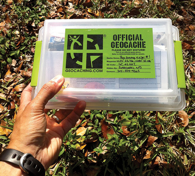
The most common type of geocache is a single hidden physical container (fig. 1). Over the years, however, geocaches have evolved into several variants, including multistage caches, puzzle caches, and letterbox hybrids (which incorporate the use of clues in addition to coordinates). At a minimum, most cache containers are usually stocked with a pen and logbook (which serves as a guest book, of sorts) and a variety of inexpensive trinkets that visitors are free to trade. Though containers are intended to be readily accessible to searchers, they are typically camouflaged and well hidden beneath structures, rocks, or vegetation to prevent casual detection. Some caches lack containers altogether and instead direct participants to social gatherings, GPS-enabled games, volunteer events, or educational opportunities.
Applied experience with geocaching reveals that the activity can serve purposes beyond simple recreation. Various organizations have used it as a means of cultivating tourism, using caches to highlight unique environmental, historical, or cultural assets sometimes overlooked by area visitors (Boulaire and Hervet 2012). In the realm of formal education, geocaching has been used in both primary and secondary school settings as a means of engagement on topics of geography (Paulus et al. 2007) and mathematics (Bragg et al. 2010), as well as to promote physical exercise.
Geocaching in the national parks
Some have suggested that—given its conceptual resemblance to modern-day treasure hunting—geocaching can be a logical avenue by which to introduce tourists to the tangible and intangible treasures that await their discovery (Boulaire and Hervet 2012). This idea has particular relevance for interpretation in national parks, which endeavors to facilitate connections between park visitors and the resources they come to see. Nonetheless, the National Park Service (NPS) has generally proceeded with caution in permitting geocaching on its lands, and the activity has, to date, not been widely accepted.
Current NPS management policies help define appropriate visitor uses in national parks, and provide guidelines for the protection of natural, cultural, historical, and wilderness resources (NPS 2006). Though these policies highlight issues of concern relative to geocaching, the policies do not expressly forbid the activity. Rather, they include provisions allowing for a wide variety of public uses, provided they are consistent with a park’s purpose and do not result in unacceptable impacts. In 2009 the National Park Service issued policy guidance specifically addressing geocaching and other forms of GPS-based recreation. Citing the great diversity among units of the National Park System, this guidance acknowledged that location-based activities may be appropriate in some areas, and granted superintendents the authority to “make determinations on a case-by-case basis” (NPS 2009).
Having recognized the longevity and growing popularity of geocaching, some national park sites have sought to capitalize on a perceived opportunity to engage a particular segment of park visitors (Reams and West 2008). To do so, a handful of parks have introduced park-sponsored caches, which in most cases are owned and managed by the park as an officially sanctioned educational visitor activity. These parks have adopted a series of strategies regarding cache type and placement to address concerns about potential impacts, and employ adaptive management to address problems should they arise. These early programs have illustrated some of the potential benefits to be had by engaging the geocaching community, and serve as a model for the program described herein (Reams and West 2008).
Methods
NPS Photo
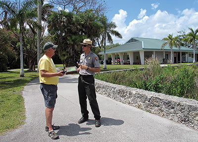
Everglades National Park (hereafter “Everglades”) initiated a one-year pilot project to gauge the impacts and efficacy of physical geocaches as a communication and interpretation tool (fig. 2). Park interpretive staff (including the authors) developed a total of five physical geocaches and deployed them inside the boundaries of the park in January 2013, and closely monitored their usage throughout the trial period. All caches were located along trails and improved surfaces along the main park road. We determined site selection in consultation with interpretive, law enforcement, and maintenance personnel overseeing each locale. Caches ranged in distance from 0.25 to 38.0 miles (61 km) from the southernmost entrance of Everglades. We used multiangle photography to document site conditions at each selected location prior to cache placement.
NPS Photo
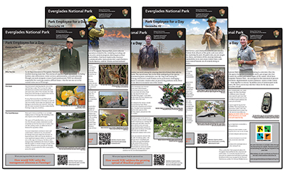
Cache descriptions and coordinates were published on both Geocaching.com and the Everglades Web site. Because these five caches occurred along a linear feature explored in its entirety by many visitors, we decided to develop these caches as a cohesive “geocache trail.” Thus, the caches shared a common theme: each cache encouraged visitors to assume the role of a different park employee. Four of the five caches introduced participants to a specific member of the park team and a real-world management challenge he or she faced. This information was conveyed through both the online cache description and a series of site bulletins specifically developed for distribution via each cache (fig. 3). A summary of this content is provided in table 1.
| Table 1. Summary of Everglades National Park cache locations and themes | ||
|---|---|---|
| Cache Location | Park Employee Featured | Park Issue Highlighted |
| Ernest Coe Visitor Center, Main Entrance | None | Cache served as introduction to series |
| Anhinga Trail, Royal Palm Visitor Center | Park Ranger | Potential human-animal conflict between alligators and visitors along popular Anhinga Trail |
| Old Ingraham Highway, Research Road | Park Botanist | Ongoing infestation of invasive Brazilian pepper and limitations of present control techniques |
| Deer Hammock, Main Park Road | Park Fire Management Officer | Threat posed by wildfire to nesting colony of endangered Cape Sable seaside sparrows |
| Visitor Campground, Flamingo | Park Superintendent | Destruction of Flamingo structures by hurricanes, and realities of rebuilding in light of sea-level rise |
We designed the caches to encourage introspection and solicit feedback from participants, building on the increasingly popular use of facilitated dialogue as an interpretive technique (Abram 2007). In both the online cache description and each site bulletin, participants were specifically invited to leave their thoughts as to how they would deal with each issue while logging their finds on Geocaching.com. Participants were also invited to learn how the park has actually responded to each issue by visiting custom-crafted Web pages for each cache, which could be accessed either from a link in the online cache description or via a quick response (QR) code on the accompanying site bulletin.
Once the caches were in place, park staff maintained them over the course of a full year, and recorded all related online activity.
Results
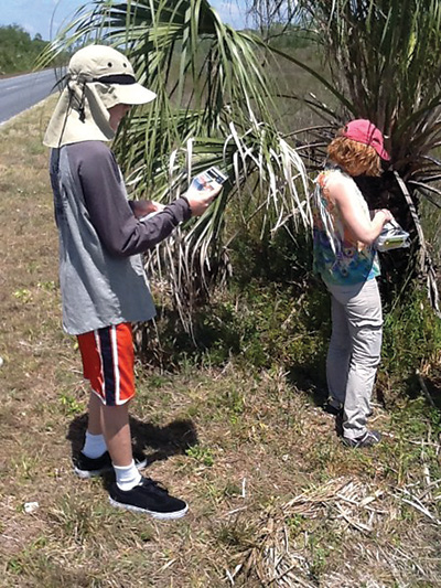
Image Courtesy of Geocaching.com
We evaluated the pilot project across five criteria: overall use, geographic reach, desired level of engagement, QR code use, and site impacts from visitor use. The results of each evaluation metric follow.
Overall use
To compile usage statistics, we reviewed participant cache logs created and hosted on Geocaching.com. These online logs are used to record when a particular cache was successfully found (or not found). Log entries also provide an opportunity for participants to submit photos and open-ended comments about the experience. These logs are informal, entirely voluntary, and are submitted using the participant’s Geocaching.com username.
Each geocache also contained blank logbooks in which participants could physically record their find.1Information recorded in these logbooks generally mirrored that posted online. Though additional visitation statistics might have been gleaned from reviewing these logbooks, they were not included in our analysis for several reasons—most notably, the loss of some due to theft and flooding.
1Blank logbooks are recommended in part to ensure that a park does not intentionally collect any personally identifiable information (PII) or appear to be conducting a survey.
A total of 1,403 unique visitor contacts were made across all five caches. The number of unique visitor contacts was derived from qualitative information contained in the cache logs, such as references to family members, use of plural pronouns, and submitted photos (fig. 4). Usage statistics, therefore, should be considered conservative estimates, because individuals do not always volunteer information about travel companions or group size.
The five cache locations yielded an average of 281 unique visitor contacts, with an average of 1.47 contacts per logged visit. Cache use was significantly higher at areas of high visitor use (i.e., visitor centers and popular trails) than in more remote or less traveled areas.
Geographic Reach
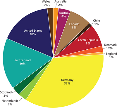
We reviewed online cache logs to gain insight into use of caches by domestic and international visitors. Out of 952 total cache logs, 179 (18.8%) held explicit information regarding a visitor’s place of origin. These logs included representation from 10 U.S. states and 13 countries. Figure 5 illustrates the proportion of cache visitors by nationality, as reported through cache logs.
Accurately assessing the true demographics of cache users is impossible from the present data set, as most visitors did not feel compelled to disclose their area of origin. These data are of interest, however, in beginning to understand the potential reach of, and principal audiences for, this type of activity. The information provided reflects an overwhelmingly large proportion of users from Europe (71%) and North America (26%).
Desired level of engagement
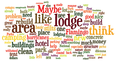
In four of the five caches placed in Everglades, a site bulletin encouraged visitors to consider a real-world problem facing park managers and to weigh in on how they might remedy the situation while logging their cache. We reviewed all logs across these four caches (n = 667) to assess how many had endeavored to answer the question, thereby reaching our desired level of engagement.
Of the logs we reviewed, 129 (19.3%) contained opinions and ideas in response to the questions posed. Nearly one in five respondents achieved the desired level of engagement by participating in a two-way dialogue about site-specific issues, making recommendations reflecting a wide diversity of opinions and viewpoints (fig. 6). In many cases, visitors commented not only on the original question posed, but also on responses submitted earlier by others. Numerous respondents indicated they enjoyed learning about park issues and hearing thoughts from their fellow hobbyists.
Quick response (QR) code use
There is considerable interest across the National Park Service in using QR codes in affiliation with exhibits, programming, and visitor center operations to quickly link people to relevant information online. As an extension to our activity, we developed online information that described park solutions to the specific problems posed at four of the five caches. Unique QR codes were used at each cache to link visitors directly to this information. We used the Google URL shortener, goo.gl, to generate all QR codes and track them over time.
A total of 667 physical visits were logged across these four caches. By comparison, all affiliated QR codes yielded a combined total of only 22 clicks, representing only 3.3% of recorded visits. The target Web pages enjoyed significantly higher visitation when accessed through the park Web site. It should be noted, however, that cellular reception is required for using QR codes. Presently, three of the cache locations receive reliable service from only one major national provider, and two of the cache sites generally have no service whatsoever. We have little doubt that usage would increase with enhanced coverage, but to what extent remains unclear.
NPS Photos
Site impacts from visitor use
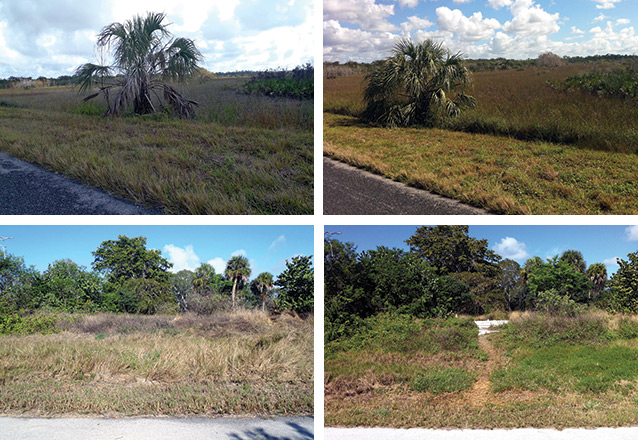
After one year, we took repeat multiangle photographs at each cache location to document any resource impacts. Four of the five sites, including two that required some degree of vehicle access, showed no visible impacts associated with use. The Flamingo site, however, showed notable change—namely, the development of a visible social trail leading to the cache site (fig. 7).
Formation of the trail at Flamingo was not wholly unexpected, and was discussed across divisions during the planning phase of the project. Because the cache was located in a disturbed locale (the site of the old Flamingo Lodge), the potential for this impact was deemed acceptable. Also, the presence of a conspicuous and active osprey nest immediately adjacent to the cache site makes it difficult to fully attribute the social trail to geocaching. Though the social trail initially formed following placement of the cache, it has likely been maintained through the combined actions of both geocachers and birders attempting to approach the nest. There is general support for the merits of the activity at this site (Showler 2014) but modifications to this location are being discussed with Flamingo personnel and park managers.
Conclusions
Our pilot project provides compelling justification for the selective use of geocaching as an interpretive tool. Many parks are increasingly engaging audiences on controversial topics through facilitated dialogue and civic engagement. A well-designed geocaching program can be an effective, nonpersonal venue by which to provoke a diverse audience to think about, and comment on, issues of importance to them, while also considering the opinions of their peers.
Roughly 20% of visitors engaged fully, responding to the management dilemma posed. The merits of this response rate can perhaps best be evaluated through comparison with other interpretive techniques. What percentage of visitors, for example, might be induced to share their viewpoints during a traditional illustrated talk or guided walk? And furthermore, what is the potential for these opinions to be considered by subsequent park visitors or park managers once shared? Here, geocaching seems to have an edge over traditional interpretive techniques, as a running record of responses provides fodder for continued discussion and consideration by activity participants and park personnel.
Our experience informs us that unwanted impacts can be minimized through proper site selection, consultation with multidisciplinary park staff, ongoing monitoring, and adaptive management. The pilot program also provides us with a useful count of average visitor use per cache log, which can now serve as a multiplier to roughly estimate future visitor use with greater ease. Last, our experience provides little optimism that QR codes provide much interpretive value because of the assumed lack of cellular service across many park areas and a general disinclination of park visitors to use them.
Acknowledgments
The authors would like to thank Dan Kimball and Marcia Keener of the National Park Service for their unwavering support of this project. We also wish to thank Jenn Seva, with Groundspeak, for her continued interest and advice, and Alice Clarke for her careful review of early drafts. Finally, we would like to thank Rick Anderson, Hayley Crowell, Sabrina Diaz, Fred Gold, Fred Herling, Robert Newman, Jonathan Taylor, and Tony Terry for their kind assistance in developing the interpretive components described.
References
Abram, R. J. 2007. Kitchen conversations: Democracy in action at the Lower East Side Tenement Museum. The Public Historian 29(1):59–76.
Boulaire, C., and G. Hervet. 2012. New itinerancy: The potential of geocaching for tourism. International Journal of Management Cases 14(4):210–218.
Bragg, L. A., Y. Pullen, and M. Skinner. 2010. Geocaching: A worldwide treasure hunt enhancing the mathematics classroom. MAV 2010: Proceedings of the 47th Annual Conference of the Mathematical Association of Victoria. Mathematical Association of Victoria, Brunswick, Victoria, British Columbia, Canada.
Groundspeak, Inc. 2013. Geocaching 101. Accessed 9 May 2013 at http://www.geocaching.com/guide/.
———. 2014. Geocaching. Accessed 30 January 2014 at http://www.geocaching.com/.
National Park Service (NPS). 2006. Management policies 2006. National Park Service, Washington, D.C., USA.
———. 2009. Policy review: GPS-based recreational activities in national park areas. National Park Service, Washington, D.C., USA.
Paulus, G., H. Scheriau, and T. Piechl. 2007. GEOGAMES—A fun-based concept to interest grammar school students in spatial sciences. 10th AGILE International Conference on Geographic Information Science, Aalborg University, Aalborg, Denmark.
Reams, V., and S. West. 2008. Agency-sponsored treasure hunts: Providing alternatives to traditional geocaching. Pages 144–150 in Rethinking protected areas in a changing world: Proceedings of the 2007 GWS Biennial Conference on Parks, Protected Areas, and Cultural Sites. George Wright Society, Hancock, Michigan, USA.
Showler, R. 2014. Interview by Larry Perez and Rudy Beotegui. 6 February.
About the authors
Larry Perez and Rudy Beotegui are with the National Park Service, Everglades National Park, 40001 State Road 9336, Homestead, FL 33034.
Documentation
Suggested citation for this article
Perez, L., and R. Beotegui. 2015. Satellite communications: Geocaches as interpretation. Park Science 32(1):30–35.
This article published
Online: 4 September 2015; In print: 14 September 2015
URL
https://www.nps.gov/articles/parkscience32_1_30-35_perez_beotegui_3818.htm
This page updated
16 September 2015
Site navigation
Last updated: August 9, 2018
