Last updated: August 15, 2019
Article
Sea Level Rise & Anchialine Pools
Global Sea level Rise
Global sea level will rise between 0.2 m and 1.9 m by 2100 according to the Intergovernmental Panel on Climate Change (IPCC). Sea level rise is caused by a combination of processes including the melting of polar ice caps and glaciers, thermal expansion of ocean water, mining of groundwater aquifers, and, in places like Hawai‘i Island, subsidence of land masses (the island is slowly sinking). Estimates of sea level rise vary depending on the trajectory of global greenhouse gas emissions, and are based on different scenarios established by the IPCC. The more extreme values of sea level rise (1.9 m) reflect a future emissions scenario in which global population growth is coupled with continued intensive fossil fuel use. In all scenarios, rates of sea level rise are accelerating and will continue to accelerate in the future.
Geospatial predictions of coastal change under sea level rise typically pair current coastal elevation data and future sea level scenarios. These models tend to be conservative because they often do not incorporate future tectonic uplift or subsidence, high wave events, or shoreline erosion which will exacerbate coastal inundation and change, especially during large episodic events (e.g. storms or tsunamis). In some coastal areas, groundwater floating on top of denser, more saline water, may also exacerbate flooding as sea levels rise. In all sea level rise models, predictions should be viewed with the understanding that there is considerable regional and local uncertainty in the future propagation of storms and waves, vertical land movement, and variation in basin wide processes such as the El Niño Southern Oscillation and the Pacific Decadal Oscillation.
Parks at Risk


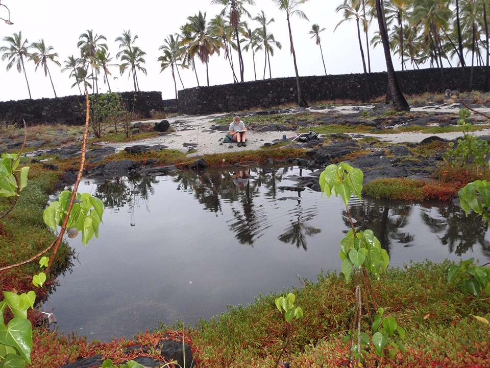
Left image
An anchialine pool in a popular area of Pu‘uhonua o Hōnaunau National Historical Park.
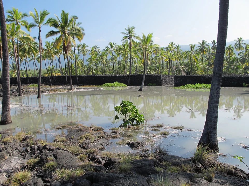
Right image
The pool and grounds were later inundated by a tsunami in 2011. The impacts of large waves from tsunamis and storms will intensify along the coast as sea levels rise, changing the landscape forever.
Predicting Changes to Anchialine Pools
Anchialine pools are brackish coastal ecosystems without a surface connection to the ocean, where groundwater and ocean water (from underground) mix. In Hawai‘i, groundwater flows through these pools and out to wetlands and coral reefs making them valuable indicators of broad-scale groundwater recharge and contamination. The NPS Pacific Island Inventory & Monitoring Network takes regular measurements of the water quality and overall health of park pools, which are found no other place in the United States outside of Hawai‘i. Hawaiian anchialine pools are tidally influenced, range in size from less than 1 m² to over 3000 m² and support diverse endemic plants and animals, including seven species listed as Candidate Threatened or Endangered Species. Anchialine pool shrimp and mollusk species disperse throughout the ocean as larvae and through groundwater as larvae or adults.
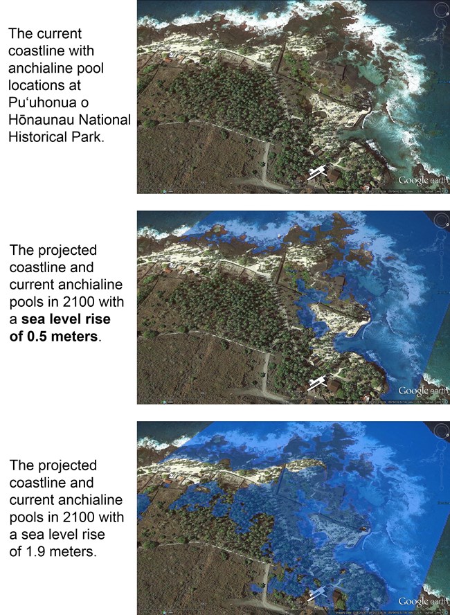
A total of 193 anchialine pools have been mapped at Kaloko-Honokōhau National Historical Park, 15 at Pu‘uhonua o Hōnaunau National Historical Park (PUHO), and 16 at Hawai‘i Volcanoes National Park. When the pool locations are overlain on maps depicting inundation scenarios, the extent of inundation can be calculated. At the 0.5 m sea level rise scenario at all three parks, current pools become larger but they are not generally inundated or connected overland to the ocean. In PUHO at a 1 m scenario, 50% of the pools are inundated and become connected to the ocean. For the 1.9 m scenario at the extreme tide, only a few pools continue to be isolated while 71% become inundated at PUHO.

Sea Level Rise Scenarios
Incorporating detailed elevation data and sea level rise predictions in coastal planning should aid in long-term management of both developed and natural areas. In particular, this project aims to identify key areas to preserve for maintaining environmental and cultural integrity in the future. For example, while some features such as individual anchialine pools will be inundated, anchialine pool, fishpond and wetland habitats will emerge or shift in the landscape, essentially fostering new habitats. Protecting future potential habitat from development will conserve valuable land, and will reduce the need to repair or relocate infrastructure placed in these areas. The goal of this project is to share sea level rise inundation scenarios with NPS staff as well as public and private partners so that everyone can plan for the future condition of Hawai‘i's shorelines.
For More Information
For a much more in-depth report, read the source article by Lisa Marrack and Patrick O'Grady from the University of California, Berkley. View it from the University of Hawai‘i at Manoa's website, or download it directly.
Additional Links
Pacific Island Inventory & Monitoring Network
Inventory & Monitoring at Hawai‘i Volcanoes National Park
Inventory & Monitoring at Kaloko-Honokōhau National Historical Park
Inventory & Monitoring at Pu‘uhonua o Hōnauna National Historical Park
Intergovernmental Panel on Climate Change (IPCC)
Download PDF from the Data Store
Tags
- hawaiʻi volcanoes national park
- kaloko-honokōhau national historical park
- puʻuhonua o hōnaunau national historical park
- anchialine pools
- threatened species
- endangered species
- endemic species
- climate change effects
- pacn
- im
- kaloko-honokohau national historical park
- vital signs
- monitoring
- hawaii
- pacific islands
- hawaii volcanoes national park
- puuhonau o hōnaunau national historical park
- climate change
