Last updated: April 2, 2018
Article
Ozone Risk Assessment for Vital Signs Networks
Ozone risk assessment uses a biologically-based method to evaluate the risk of foliar injury from ozone at parks in the 32 Inventory & Monitoring Networks, the Appalachian National Scenic Trail, and the Natchez Trace National Scenic Trail. The assessment allows resource managers at each park to better understand the risk of ozone injury to vegetation.
Initial assessments were completed in 2004 using ozone monitoring data from 1995–1999. A reassessment of ozone risk was completed in 2007 for 8 National Park units using monitoring data from 2000–2004 in parks that appeared to experience increased levels of ozone exposure since the initial assessment. Together the two assessments provide insight about changes in ozone exposure over a ten-year period, and examine how the changes may have altered the risk of ozone injury to plants.
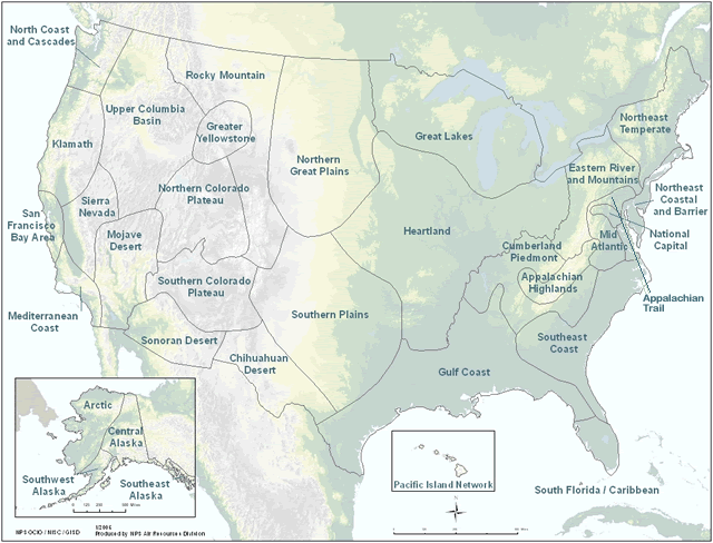
Select a network or trail from the map or list below to view an assessment.
Ozone Risk Assessment Network Map

Compilation of Networks
Network Assessments
- Appalachian Highlands
- Appalachian National Scenic Trail
- Arctic
- Central Alaska
- Chihuahuan Desert
- Cumberland Piedmont
- Eastern Rivers and Mountains
- Great Lakes
- Greater Yellowstone
- Yellowstone National Park–2006 Update
- Gulf Coast
- Heartland
- Klamath
- Mediterranean Coast
- Mid-Atlantic
- Mojave Desert
- Death Valley National Park–2006 Update
- Great Basin National Park–2006 Update
- Natchez Trace National Scenic Trail
- National Capital Region
- North Coast & Cascades
- Northeast Coastal & Barrier
- Northeast Temperate
- Northern Colorado Plateau
- Northern Great Plains
- Pacific Island
- Rocky Mountain
- Rocky Mountain National Park–2006 Update
- San Francisco Bay Area
- Sierra Nevada
- Sequoia and Kings Canyon National Parks–2006 Update
- Sonoran Desert
- South Florida/Caribbean
- Southeast Alaska
- Southeast Coast
- Southern Colorado Plateau
- Mesa Verde National Park–2006 Update
- Grand Canyon National Park–2006 Update
- Southern Plains
- Southwest Alaska
- Upper Columbia Basin
- Craters of the Moon National Historic Park–2006 Update
