Last updated: May 8, 2020
Article
Nicollet Rock

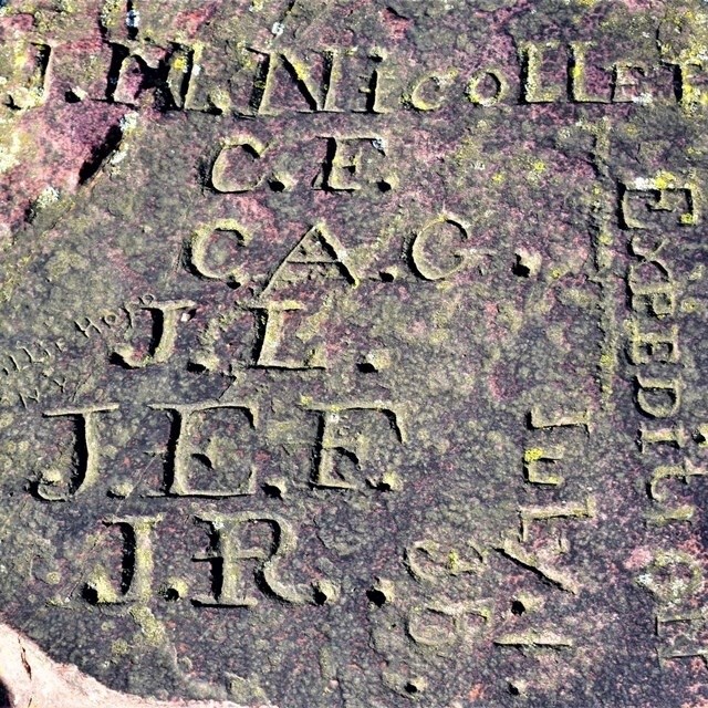
NPS/N.Barber
Nicollet's group arrived at the pipestone quarries on June 29, 1838 and stayed until July 6, 1838. While there, the team attempted to make astronomical observations for mapmaking and navigation, recorded their observations of the stories and traditions of the people using the quarries, and even tried their hand at quarrying, though they caused some discomfort by using explosives.
While encamped at the quarries, some members of the Expedition set out to carve their initials on a quartzite rock near Winnewissa Falls. On June 30, 1838, Joseph Laframboise was carving his initials on the rock when, as Nicollet recorded, a Waȟpékhute Dakota man "came up to him to touch his shoulder and ask what he was doing there." As it turned out, the two men were acquainted with each other and the man had been watching the Expedition's movements and activities for several days. The man and his family camped with Nicollet's men starting the next day. The rock on which Laframboise was carving is still visible today along the Circle Trail.
On July 4, Expedition member John C. Frémont leapt onto the Leaping Rock and planted the U.S. flag to celebrate Independence Day. As Nicollet recorded, "The colors of the United States are unfurled on the summit of a large, sharp-cornered rock, 23 feet high, standing isolated in front of the hill, it's four faces precipitous...One cannot reach the summit of the rock by any of the flanks. It is necessary to jump from the top of the hill to the summit of the rock and land there firmly balanced...Mr. Frémont was assigned this perilous operation and executed it successfully." Frémont later led five expeditions of his own in the West and ran for President of the United States. The Leaping Rock is adjacent to the Nicollet Rock.
Twenty years after Nicollet's group had camped at the quarries with Dakota families, the U.S. government attempted to force the Dakota onto reservations. Ihanktonwan leader Struck By The Ree insisted that access to the quarries be guaranteed before his people were moved 150 miles to the south. The U.S. agreed, and in 1858, the pipestone quarries were turned into a 1-square-mile reservation. The center-point used to create the reservation boundary was the Nicollet Rock.
In 1925, the Catlinite Chapter of the Daughters of the American Revolution installed a plaque on the side of the Nicollet Rock to commemorate the famous expedition.
Learn more about the men who carved their names into the quartzite rock.
