Desert sand dunes interact strongly with external drivers, including wind, vegetation, and groundwater. Given the ubiquity of sand dunes on Earth’s deserts and on extraterrestrial environments, this research aims to understand how dune fields respond to these complex external forces.
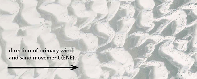
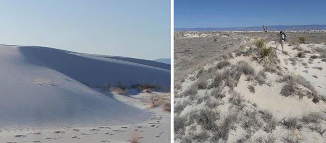
A particularly striking feature of the dune field at White Sands National Monument (NM) is the systematic change in dune patterns from west to east along the primary direction of strong winds and sand transport. The western section of White Sands NM is covered by unvegetated barchan dunes (characterized by dune arms facing downwind), while the eastern section is covered by vegetated parabolic dunes (dune arms facing upwind). What is the source of this and other spatial patterns at White Sands NM?

Methods
Our work is based on a combination of remote sensing, meteorological records, and ground-based observation. Dune field morphology and vegetation patterns were determined from records of repeat aerial imagery and airborne LiDAR (a Light Detection and Ranging remote sensing method). Differences in annual LiDAR topographic surveys yielded a detailed spatial map of sand flux (movement) estimates. Meteorological records of wind speed and direction at Holloman Air Force Base (AFB) were used to estimate long-term wind climate at White Sands. Ground penetrating radar (GPR), confirmed with local well observations, provided a map of depth to water table across the dune field.
|
Objectives Objective 1 - Determine the origin of the barchan-parabolic dune transition. Objective 2 - Understand the connections between atmospheric processes and sand transport patterns. Objective 3 - Measure and explain patterns of water table variation across the dune field. |
Results and Discussion
Strong southwesterly winds blowing across the Alkali Flat encounter an abrupt transition in surface roughness as they approach the upwind margin of the White Sands dune field. At this roughness transition, fluid mechanical theory predicts the formation at an internal boundary layer, causing an abrupt increase then gradual decrease in surface wind stress downwind across the dune field. Accompanying this spatial gradient in wind stress, sediment transport laws predict a corresponding abrupt increase then gradual decrease in sediment flux across the dune field. Spatial predictions of sediment transport based on this internal boundary layer theory and Holloman AFB wind records match closely with estimates of sediment transport based on LiDAR-derived dune migration rates.
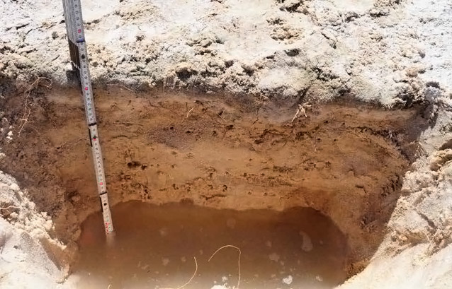
At 7-8 km downwind of the Alkali Flat, dunes transition from barchan to parabolic shapes as they are colonized by vegetation (Figure 1). Our theory shows how vegetation colonizes dunes when the rate of wind-blown sand transport drops below a certain threshold value. Plants colonize dune arms before colonizing dune centers, causing an inversion in the dune shape from barchan to parabolic (Figure 2). We also observe an abrupt decline in water table elevation (from 0.5 to 1 meter) at the barchan-parabolic dune boundary, as the presence of vegetation shifts the water table balance (Figure 3).

© Raleigh Martin

Management Implications
White Sands is a constantly-evolving, dynamic landscape displaying strong spatial heterogeneity. The barchan-parabolic transition shows how a subtle shift in wind patterns can cause a dramatic change in dune, vegetation, and groundwater patterns. Such strong landscape sensitivity provides a basis for understanding past changes in ecological and human settlement patterns in response to evolving climate. Such sensitivity also suggests the fragility of the White Sands NM landscape, providing a reason for caution in management of this valuable resource.
Collaborators
Raleigh L. Martin, Douglas J. Jerolmack, Federico Falcini, Claire Masteller, Colin Phillips, and Meredith D. Reitz
University of Pennsylvania
Ryan C. Ewing, University of Alabama
Ilya Buynevich, Temple University
For Further Reading by the Authors:
Internal boundary layer model for the evolution of desert dune fields. Nature Geoscience 5(3):206-209. 2012.
We thank K. Litwin, A. Bhattachan, A. Boles, and B. McNutt for their assistance in collecting these data. LiDAR data supplied by G. Kocurek.
Prepared in collaboration with the National Park Service, 2012.
Last updated: June 13, 2018
