Article

An Increase in Fires for Lake Clark
By Deborah Coble and Larry Weddle
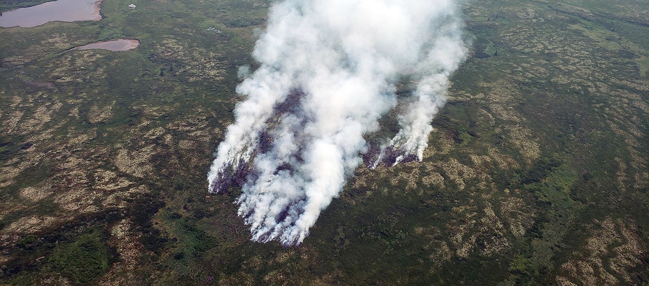
Significant smoke rises from a wooded area in Lake Clark National Park and Preserve.
The over 300-acre Snipe Lake Fire was a lightning-caused fire in Lake Clark National Park and Preserve discovered on July 9, 2019.

NPS photo/E. Rupp

In 2019, extreme fire weather indices and record setting temperatures created significant impacts throughout Alaska. Many regions in the state saw numerous fires some of which were long duration fires, structure loss and hazardous smoke conditions. With an estimated population of over 735,000, very few of Alaska’s residents weren’t impacted in some way by this year’s fire season.

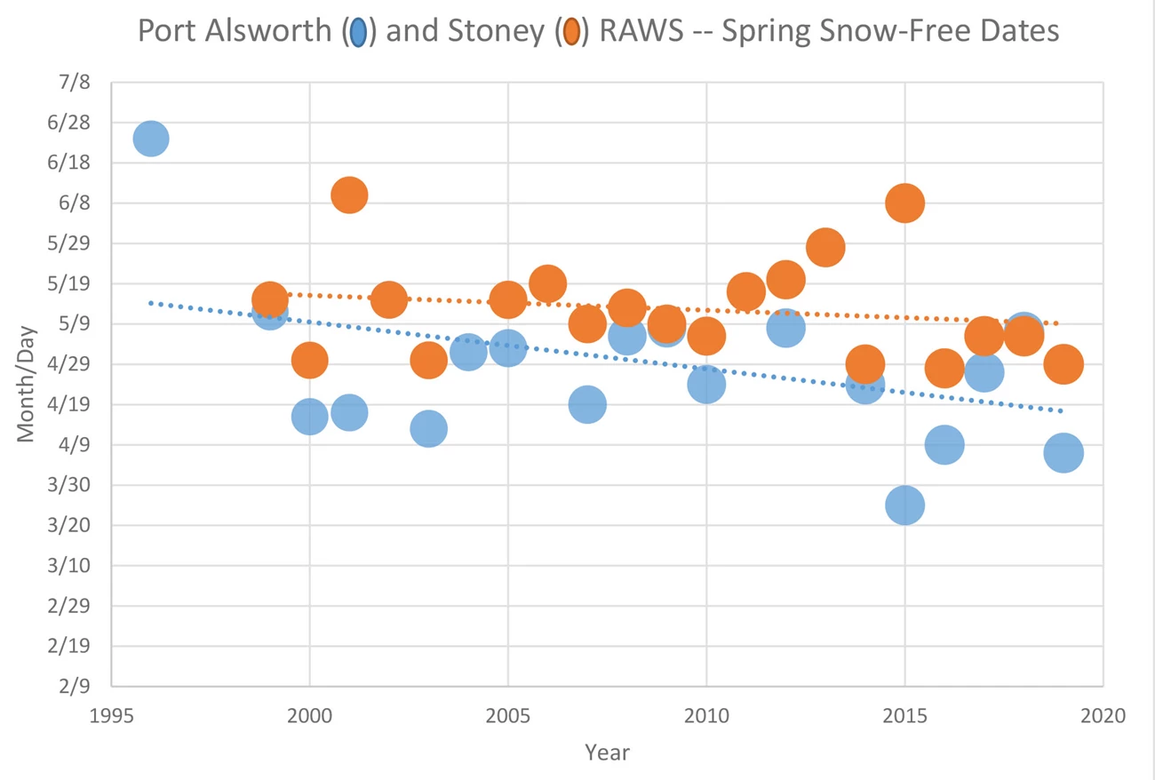
For Lake Clark National Park and Preserve the wildfire season started relatively normal with the exception of the two remote automated weather stations (RAWS) having some of the earliest snow-free dates recorded (Port Alsworth RAWS 1996-2019; Stoney 1999-2019) within the last 20 years. Snow-free dates help forecast the fire danger (Canadian Forest Fire Danger Rating System - CFFDRS) calculations for the year. Fire managers in Alaska frequently use CFFDRS to evaluate environmental conditions that influence ignition, behavior, and spread of wildland fires. CFFDRS is a combined system of codes and indexes that provide the maximum amount of fire danger information from a minimum amount of daily weather data.
Chart depicting earlier spring snow-free dates for Port Alsworth and Stoney.
Overall, there is a steady movement toward earlier spring snow-free dates reported for both the Port Alsworth ad Stoney Remote Area Weather Stations.
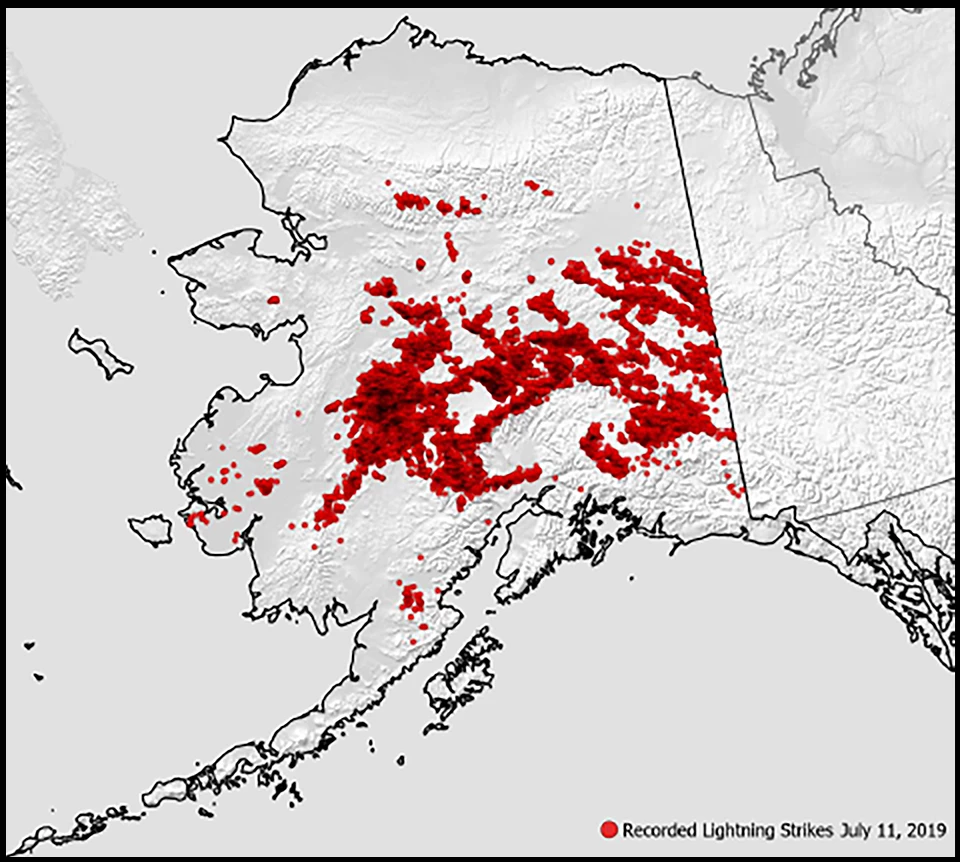
While Lake Clark itself does not have a high occurrence of wildfires (33 recorded wildfires during 1957-2018), particularly on the coastal and mountainous regions, wildfire occurrence increases to the west and northwest of the park and preserve. Approximately one-half of the wildfires in Lake Clark are natural caused (lightning) with the remaining wildfires caused by human activity. To give an example, on July 11, there were 25,157-recorded lightning strikes in Alaska. Most of those strikes occurred over the southern Interior.

The season’s single biggest day for thunderstorm activity was on July 11 with 25,157-recorded strikes. AICC image.

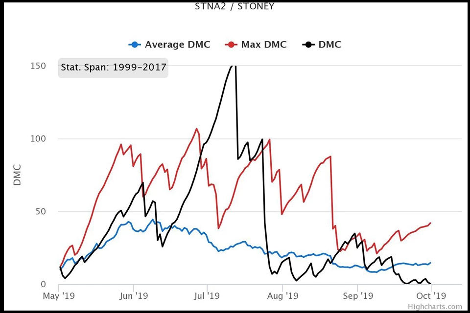
There are three fuels thought to be the most important for understanding fire danger in boreal and temperate forests: Litter, measured as a Fine Fuel Moisture Code/FFMC, the loose duff material, measured as the Duff Moisture Code/DMC, and deep, compacted organic fuels or Drought Code/DC. For the park and preserve, when the duff moisture code, a measure of the moisture content just below the green moss that covers much of the forest floor, is at or above 60 DMC (moisture content of 72.9%) it is a pretty good indicator that fire can smolder overnight in the duff material. When DMCs reach 20 and higher there is greater potential for lightning ignitions.

By June 1 of this year, the Stoney RAWS reached a DMC of 61 and by June 11, the Port Alsworth RAWS reached a DMC of 62 and the first wildfire in LACL, Round House Mountain, was discovered. Based on the location (proximately of identified values to be protected) of the wildfire and the time of the season (the potential that the fire could negatively impact multiple sensitive resources over time) the fire was suppressed by Mat-Su/Southwest Area Forestry and declared out on June 13 at 2 acres.

On June 12, two fires were discovered west of LACL along the Chulitna River, near Long Lake. Both fires were suppressed with suppression resources within a couple of days.

DMCs correspond to daily rainfall, temperatures and humidity. June and July were hot and dry. By June 28, Stoney RAWS began setting new daily records for recorded DMCs and by July 3, began setting new records for the highest DMCs ever recorded at Stoney RAWS. Meanwhile in Port Alsworth, the RAWS began setting new daily records for recorded DMCs on July 3 and by July 4, began setting new records for the highest DMCs ever recorded at this location.

The hot and dry weather persisted and on July 8, a new fire was discovered southwest of LACL called the Pete Andrews Creek Fire, near Iliamna Lake. While Mat-Su/Southwest Area Forestry attempted to suppress this fire, the extreme fire danger coupled with the competition for fire suppression resources across the state, the containment efforts were ineffective (low probability of success) and the fire was placed into a monitor status. The smoke from this fire was visible and impacted LACL.
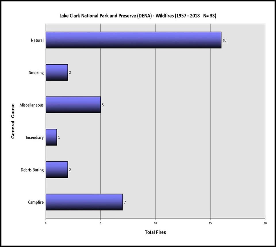
Blue lines indicating highest number of fires in LACL are naturally caused. Blue lines indicating highest number of fires in LACL are naturally caused.

Left image
The number one cause for wildfires in Lake Clark National Park and Preserve are natural, lightning-caused fires followed by campfires.

Right image
The red dots depict recorded lightning strikes on July 11, 2019.
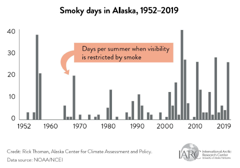
2019 shows a rapid increase in the amount of smoky days in Alaska
Alaska has seen smoke for decades, but a clear increase in number of days each season is noted.

Alaska Center for Climate Assessment and Policy/R. Thorman

Often times, especially in June and July, the thunderstorms that can be quite active over the Interior of Alaska, don’t always come with wetting rains, but usually have wind. The winds can further dry the fuels. So combine ultra-dry fuels, winds and lightning strikes and we now have the perfect setting for wildfires and lots of them. On July 9, after a series of thunderstorms the Snipe Lake Fire was discovered in LACL. Based on the location and the few identified values to be protected from wildfire, fuels in the area, and the low probability of the fire reaching values of high concern, the fire was monitored for the remainder of the summer. Nevertheless, it was apparent the conditions for additional fires were increasing and LACL disseminated the news release, “Extreme Fire Danger: Lake Clark National Park and Preserve encourages caution with use of campfires and to report new wildfires.”

On July 10, a new fire was discovered west of the park and preserve, called the Chilchitna Headwaters Fire located near the Chilikadrotna River. The Chilikadrotna River is a popular rafting river for visitors who begin their float in LACL. Also on this day, LACL adopted the State of Alaska implemented fire restriction which included the portion of LACL that was within the Kenai Peninsula Borough.

Toward the end of July, there was some relief in the weather. The weather event that significantly reduced wildfire potential growth was widespread across southern and southwest Alaska. The Stoney RAWS finally stopped breaking daily high records of DMCs on July 24 resulting in 26 days of daily record highs. The all-time high records ceased after 10 days. Port Alsworth RAWS ceased breaking daily high records of DMCs on July 14, resulting in 12 days of daily record highs. The all-time high records came to a stop after nine days.
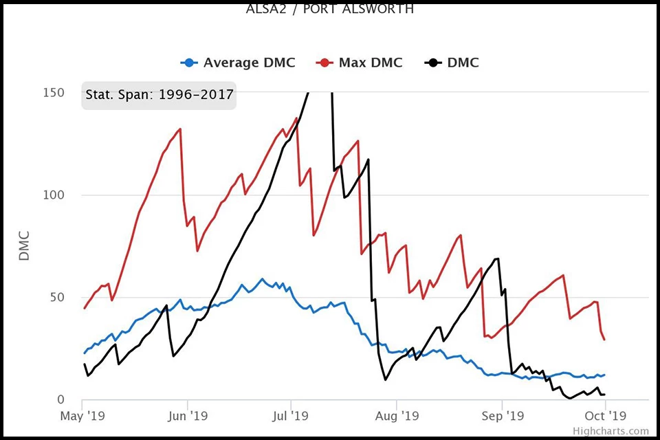
Port Alsworth DMC data Port Alsworth DMC data

Left image
Port Alsworth Duff Moisture Code Data

Right image
Stoney Duff Moisture Code Data

On July 24, LACL rescinded the adopted State of Alaska fire restrictions. Typically weather events such as this one, would have signaled the end of the season for any significant fire growth. However, the Snipe Lake Fire, despite showing no growth since July 12, had not been declared out.

Starting August 6, the weather started a slow, warm, and drying trend and once again, fire managers observed new daily DMC records. In the afternoon of September 1, wind speeds reach 41mph with gusts up to 54mph at the Snipe Lake RAWS. This resulted in Visible Infrared Imaging Radiometer Suite (VIIRS) IBand heat detections in the interior of the Snipe Lake Fire. The fire did not grow during this wind event and was finally declared out on September 26 at 326.9 acres.
In all, 684 fires burned over 2.5 million acres (1 million hectares) in Alaska this year. Smoke impacts to the park and preserve were widespread (east and west of the Alaska Range) and pervasive for long periods over the summer. The current trend is for snow-free areas earlier in the season. When this occurs, the fire season starts earlier and may result in a longer overall fire season. It also may be a contributing factor to the increase in higher fire potential. On average LACL experiences about one wildfire every other year (based on the period of record). Based on the current decade, LACL is approaching about an average of one wildfire every year, thus doubling fire activity. More acres burned in the current decade, by far, then any decade on record.

It is important to remember that with the increasing trend in fire activity, the warmer than average predicted winter for this year, and the extreme fire weather indices of last season (there are still a lot of deep, dry duff areas out there), we ask you to remain vigilant in preventing unwanted wildfires.

How to report a wildfire in your park and preserve (Internal site) (External site) and the Canadian Forest Fire Danger Rating System provides additional resources and information on the topics above.

Lake Clark National Park & Preserve

Last updated: November 18, 2019