Last updated: March 29, 2023
Article
Johnson Lake Mine: Mining for Tungsten in Nevada's Snake Range (Teaching with Historic Places)
This lesson is part of the National Park Service’s Teaching with Historic Places (TwHP) program.
Carefully tucked into the scenic western slopes of east central Nevada's Snake Range and almost 11,000 feet above sea level, Johnson Lake Mine today lies in ruins. The remains of a few log cabins, mining equipment, and artifacts (trash) from miners and their families are left to tell the story of this mining district. The mine probably played a role in the wartime efforts of the United States during the early 20th century. The deteriorating structures and the vestiges of an aerial tramway are part of what makes Johnson Lake Mine a valuable cultural resource.
Today a historic landscape in Great Basin National Park, Johnson Lake Mine's story actually begins in the early part of the 1900s, when the mineral tungsten was first discovered in the southern Snake Range. At Johnson Lake Mine tungsten was extracted and milled onsite and then transported a great distance to be refined and then used to make alloy steel. Alloy steel was used to create things like weapons, tanks, and transmitter radios during World War I. Following the war, mining activity was sporadic until the 1930s when a snowslide rushed over the mine and halted production. After that, the mine was closed and abandoned. Now in disrepair, with much of the mining equipment salvaged for use at other mines or collected by mining buffs, the site still possesses archeological resources. Archeologists are following clues, dusting off the remains of the past, and discovering the day-to-day practices of the mine and the people who inhabited the region.
About This Lesson
This lesson is based on the National Register of Historic Places registration file, "Johnson Lake Mine Historic District" (with photographs); Archeological Investigations at Great Basin National Park: Testing and Site Recording in Support of the General Management Plan by Susan J. Wells; A History of Great Basin National Park by Harlan D. Unrau; and Archeological Survey and Site Assessment at Great Basin National Park by Susan J. Wells. A preliminary draft was produced by Meghan McGinnes, a former intern to the National Park Service Archeology and Ethnography program and expanded upon by Mike Chin, a former intern to the Teaching with Historic Places program. It was rewritten and revised into its final form by Adrienne Boice, a former intern to the Teaching with Historic Places program and was edited by the Teaching with Historic Places staff. This lesson is one in a series that brings the important stories of historic places into the classrooms across the country.
Where it fits into the curriculum
Topics: This lesson could be used in U.S. history course units on the turn of the 20th-century mining boom, the first World War, and historical archeology.
Time period: Early 20th century
United States History Standards for Grades 5-12
Johnson Lake Mine: Mining for Tungsten in Nevada's Snake Range
relates to the following National Standards for History:
Era 6: The Development of the Industrial United States (1870-1900)
-
Standard 1A- The student understands the connections among industrialization, the advent of the modern corporation, and material well-being.
-
Standard 1C- The student understands how agriculture, mining, and ranching were transformed.Era 7: The Emergence of Modern America (1890-1930)
-
Standard 2C- The student understands the impact at home and abroad of the United States involvement in World War I.
Curriculum Standards for Social Studies
(National Council for the Social Studies)
Johnson Lake Mine: Mining for Tugsten in Nevada's Snake Range relates to the following Social Studies Standards:
Theme I: Culture
-
Standard A - The student compares similarities and differences in the ways groups, societies, and cultures meet human needs and concerns. Standard E - The student articulates the implications of cultural diversity, as well as cohesion, within and across groups.
Theme II: Time, Continuity and Change
-
Standard B - The student identifies and uses key concepts such as chronology, causality, change, conflict, and complexity to explain, analyze, and show connections among patterns of historical change and continuity.
-
Standard C - The student identifies and describes selected historical periods and patterns of change within and across cultures, such as the rise of civilizations, the development of transportation systems, the growth and breakdown of colonial systems, and others.
-
Standard D - The student identifies and uses processes important to reconstructing and reinterpreting the past, such as using a variety of sources, providing, validating, and weighing evidence for claims, checking credibility of sources, and searching for causality.
-
Standard F - The student uses knowledge of facts and concepts drawn from history, along with methods of historical inquiry, to inform decision-making about and action-taking on public issues.
Theme III: People, Places and Environments
-
Standard A - The student elaborates mental maps of locales, regions, and the world that demonstrate understanding of relative location, direction, size, and shape.
-
Standard B - The student creates, interprets, uses, and distinguishes various representations of the earth, such as maps, globes, and photographs.
-
Standard E - The student locates and describes varying land forms and geographic features, such as mountains, plateaus, islands, rain forests, deserts, and oceans, and explain their relationships within the ecosystem.
-
Standard H - The student examine, interprets, and analyze physical and cultural patterns and their interactions, such as land uses, settlement patterns, cultural transmission of customs and ideas, and ecosystem changes.
-
Standard K - The student proposes, compares, and evaluates alternative uses of land and resources in communities, regions, nations, and the world.
Theme IV: Individual Development and Identity
-
Standard A. The student relates personal changes to social, cultural, and historical contexts.
-
Standard B - The student describes personal connections to places associated with community, nation, and world.
-
Standard F - The student identifies and describes the influence of perception, attitudes, values, and beliefs on personal identity.
-
Standard H - The student works independently and cooperatively to accomplish goals.
Theme V: Individuals, Groups, and Institutions
-
Standard B - The student analyzes group and institutional influences on people, events, and elements of culture.
-
Standard D - The student identifies and analyzes examples of tensions between expressions of individuality and group or institutional efforts to promote social conformity.
-
Standard G - The student applies knowledge of how groups and institutions work to meet individual needs and promote the common good.
Theme VI: Power, Authority and Governance
-
Standard A - The student examines issues involving the rights, roles and status of the individual in relation to the general welfare.
-
Standard C - The student analyzes and explains ideas and governmental mechanisms to meet wants and needs of citizens, regulate territory, manage conflict, and establish order and security.
-
Standard D - The student describes the way nations and organizations respond to forces of unity and diversity affecting order and security.
-
Standard H - The student explains and applies concepts such as power, role, status, justice, and influence to the examnation of persistent issues and social problems.
Theme VII: Production, Distribution and Consumption
-
Standard A - The student gives and explain examples of ways that economic systems structure choices about how goods and services are to be produced and distributed.
-
Standard B - The student describes the role that supply and demand, prices, incentives, and profits play in determining what is produced and distributed in a competitive market system.
-
Standard E - The student describes the role of specialization and exchange in the economic process.
-
Standard I - The student uses economic concepts to help explain historical and current developments and issues in local, national, or global contexts
Theme IX: Global Connections
-
Standard B - The student analyze examples of conflict, cooperation, and interdependence among groups, societies, and nations.
Theme X: Civic Ideals and Practices
-
Standard A - The student examine the origins and continuing influence of key ideals of the democratic republican form of government, such as individual human dignity, liberty, justice, equality, and the rule of law.
-
Standard B - The student identifies and interprets sources and examples of the rights and responsibilities of citizens.
-
Standard C - The student locate, access, analyze, organize, and apply information about selected public issues recognizing and explaining multiple points of view.
-
Standard D - The student practice forms of civic discussion and participation consistent with the ideals of citizens in a democratic republic.
-
Standard E - The student explain and analyze various forms of citizen action that influence public policy decisions.
-
Standard F - The student identifies and explain the roles of formal and informal political actors in influencing and shaping public policy and decision-making.
Objectives for students
1) To outline the basic process for mining tungsten.
2) To describe the significance of mining tungsten during the World War I industrial period.
3) To explain the role of archeology in learning about Johnson Lake Mine and the people who lived and worked there.
4) To research war-related efforts in the local community and their impact during and after the war.
Materials for students
The materials listed below either can be used directly on the computer or can be printed out, photocopied, and distributed to students. The maps and images appear twice: in a smaller, low-resolution version with associated questions and alone in a larger version.
1) One map of Great Basin National Park showing Johnson Lake and the surrounding area;
2) Four readings about mining in White Pine County, laws of the White Pine Mining District, and the history and archeology of Johnson Lake Mine;
3) Three drawings demonstrating the topography, structures, and artifacts at the site;
4) Two photos of structures and artifacts at Johnson Lake Mine.
Visiting the site
Johnson Lake Mine is located in Great Basin National Park. The park is located in east-central Nevada near U.S. Highways 6 and 50 near Baker. The main park entrance is five miles west of Baker, NV, near the Nevada-Utah border. Johnson Lake Mine is open to the public, but is accessible only by foot. The trail to the site begins at 8,000 feet and ends at almost 11,000 feet elevation, so it may not be accessible to everyone. Great Basin National Park is open daily 8:00 a.m. to 4:30 p.m. Pacific Time, with extended hours in the summer. It is closed on New Year's Day, Thanksgiving Day, and Christmas Day. For more information, contact the Superintendent, Great Basin National Park, 100 Great Basin National Park, Baker, Nevada 89311, or visit the park's website.
Getting Started
Inquiry Question
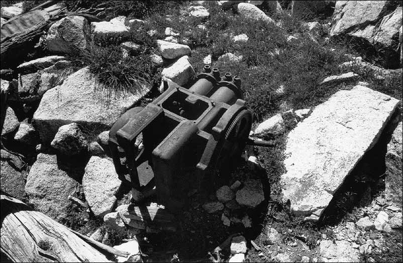
(National Park Service, Western Archeological and Conservation Center Photo)
What might this object be?
What do you think it was used for?
Setting the Stage
The discovery of the Comstock Lode, as people soon called the ore body, in 1859 brought a reverse migration from California in the "Rush to Washoe" (Washoe County, Nevada). In 1859, miners and prospectors in the western Great Basin made two remarkable strikes of gold and silver ore breaching a mountain's slope near Virginia City. The discovery of gold and silver along the twists and turns of Nevada's numerous creeks and streams heightened the fame and desirability of the area as Nevada became the land of opportunity.
Initially, interested parties who flooded to parts of Nevada were after gold and silver. However, with the ever-increasing rise of industrialization, specifically with regards to military and technological advancements, mining in the region began to take on a new character. Practical entrepreneurs began to focus on mining the metals integral to the economy at the time, most notably copper, lead, zinc, iron, and tungsten. In accordance with this growing trend toward a more diverse mining industry, new mills to process the metals began appearing. Johnson Lake Mine, a tungsten mining site of the Snake Range in east central Nevada is one such example.
Johnson Lake Mine was destroyed by a snowslide in 1935 and what remains are the remnants and ruins of the past. Archeology, a study of past peoples through items and structures that they used, helps us piece together the story of Johnson Lake Mine and the people who lived and worked there.
Locating the Site
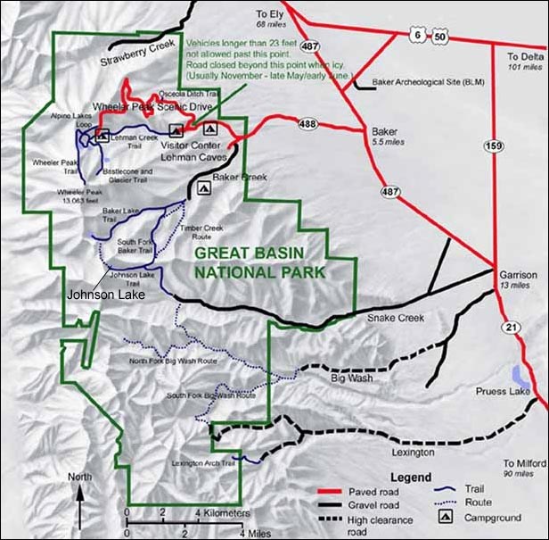
Map 1: Great Basin National Park.
National Park Service
Great Basin National Park is one of only two National Park Service units in the state of Nevada. It is part of a system of mountain ranges, streams, lakes, and broad valleys spread over Nevada, Utah, California, Oregon, and Idaho. The park's resources include streams, lakes, mountains, alpine plants, abundant wildlife, a variety of forest types including groves of ancient bristlecone pines, natural limestone caves, and archeological sites with artifacts and other remains of past peoples, from as long as 10,000 years ago to as recently as the Johnson Lake Mine.
The "Great Basin" that Great Basin National Park is named after extends from the Sierra Nevada Range in California to the Wasatch Range in Utah, and from southern Oregon to southern Nevada. This is an area where no water drains to an ocean, but drains inward. As big as it is, the Great Basin is only part of an even larger region called the Basin and Range province that extends down into Mexico. The landscape around Great Basin National Park is a good example of what is found throughout the Basin and Range province--long mountain ranges separated by equally long, flat valleys.
Questions for Map 1
1) Using a Nevada state map in your classroom or library, locate Great Basin National Park. How would you describe the park's location? Is it a heavily populated area? What is it near?
2) Locate Johnson Lake on Map 1. Use the scale to approximate the distance from Johnson Lake to the Visitor Center. Note the topography (mountains and valleys) of the region. How would you describe the site's location?
3) Locate the trail leading to Johnson Lake Mine. Johnson Lake Mine contains archeological remains such as structures, machine parts, buckets, cans, and corrugated steel sheets. Do you think the general public should be able to access the site? Why or why not? What might be the advantages and disadvantages to the location of Johnson Lake Mine?
Determining the Facts
Reading 1: The Mining Rush in White Pine County
In the 1850s, the south of the Virginia Mountain Range, in the western part of Nevada, lay dormant as a dry and desolate area. Less than a decade later, however, the region would become the center of one of the greatest mining rushes in the history of the United States. In 1859 the discovery of rich silver deposits led to the establishment of mining districts at Gold Hill and Virginia City and soon transformed the scarcely settled frontier into a bustling mining epicenter. Thousands of miners were attracted to the area, and many crossed over the Sierra Nevada Mountains to the region from the dwindling gold fields of California.
After five years of extensive mining in the Virginia Range, however, the mining district declined as a result of the near depletion of the silver deposits. Miners began to spread eastward in search of new minerals. In the spring of 1865 about a dozen of these miners discovered evidence of silver on White Pine Mountain and a new district--White Pine Mining District, an area approximately 12 square miles--was established that year.
The "mining district" was a working example of popular sovereignty, where the miners themselves determined their own laws to govern the mining of lands in the absence of a federal code. Although Nevada became a state in 1864, there was no national policy governing the mining of lands. The General Mining Act of 1866 was the first federal statute, which essentially recognized the mining districts by federal and state courts as legal entities. With an initial discovery of mineral deposits, the first miners at the site would write a compact to govern themselves and all others coming to the new mining district. The resident miners would then declare a self-governing mining district to be in existence.
News of these silver-ore claims in the White Pine Mining District quickly spread and in the spring of 1868 there was a stampede of prospectors into the area, a hurried staking of claims, and the beginnings of a large-scale mining rush. On December 14, 1868, one miner wrote of the mining rush at White Pine:
White Pine is undoubtedly one of the, if not the richest and most extensive mining localities discovered since California. The mines are not confined to one locality but extend over a scope of country some fifty by one hundred miles, and the new developments have turned out equally as rich as the first discovery.¹
Miners discovered new mineral deposits almost daily. One of these newly discovered minerals was tungsten, which was found by a group of prospectors in 1885 on the western slopes of the Snake Range in what is now Great Basin National Park. The prospectors noticed a brownish-gray granite material in veins of white quartz. Samples of the mystery material were sent to California for chemical analysis. The analysis stated that the deposits were "spectacular hematite." But later, in January of 1899, other prospectors refused to accept the previous analysis and sent ore samples to Denver. The lab in Denver concluded that the material was not hematite, but rather huberite, a valuable source of tungstic acid. The confirmation of tungsten deposits thus led to the establishment of the Tungsten Mining District in January of 1900.
Tungsten, a hard, brittle, corrosion-resistant, gray to white metallic element, is an important mineral for the production of alloy steel, a combination of iron with another metal. Although the discoverers of the tungsten in the Snake Range did not know it at the time, the value of the tungsten was about to greatly increase. The demand for tungsten soared during World War I, which began in 1914. Until the mid-19th century, steel was expensive and difficult to make. But, when steel was combined with minerals like tungsten, the cost was reduced and output production greatly increased. In addition, steel made with tungsten is self-hardening, wear resistant, and has the properties necessary to create tools with smooth cutting edges.
Steel made with tungsten was used to manufacture weapons, tanks, and ships for American soldiers fighting the war abroad. It also was used in the filament wire, a thin wire that is heated white hot by the passage of an electric current, of incandescent light bulbs that emits light as a result of being heated. These bulbs became inexpensive to produce and reliable due to development of a patented process to produce ductile tungsten, which is easily drawn into wire or hammered thin. Furthermore, tungsten was used in the tubes of two-way radios, which allowed soldiers separated by distance to communicate with one another.
The demand for tungsten created a short-lived economic boom in the Snake Range of White Pine County, Nevada. Prospectors and miners rushed to the area in search of the precious metal. In 1912, a man named John Tilford discovered a new source of the tungsten mineral in Snake Creek Canyon on the eastern slopes of the range. The mine that was soon established there, Johnson Lake Mine, was an ambitious tungsten mining complex with a mine, aerial tramway, water supply system, mill and residential area located at 11,000 feet elevation and more than 70 miles from the railroad. The story of the mine is typical as it represents a large investment of time, money, and effort in a very remote area for very little financial return--basically the story of mining throughout the west at the time.
Questions for Reading 1
1) Why did the miners originally rush to Nevada from California?
2) How were mining districts established? What is popular sovereignty?
3) Why was the White Pine Mining District established?
4) What is tungsten?
5) How was tungsten used during World War I?
Reading I was compiled from Harlan D. Unrau, Basin and Range: A History of Great Basin National Park, Nevada (U.S. Department of the Interior, National Park Service, 1990); Susan J. Wells, Archeological Survey and Site Assessment at Great Basin National Park (Tucson: Western Archeological and Conservation Center, 1990); Susan J. Wells, Archeological Investigations at Great Basin National Park: Testing and Site Recording in Support of the General Management Plan (Tucson: Western Archeological and Conservation Center, 1993); and Susan Wells, "Johnson Lake Mine" National Register of Historic Places Registration Form (Washington, D.C.: U.S. Department of the Interior, National Park Service, 1995).
¹John Curtis to [William H.] Taylor, December 14, 1868, Michell Papers, 1858-1887, Manuscript Department, Huntington Library, San Marino, California.
Determining the Facts
Reading 2: Laws of White Pine Mining District, October 10, 1865
The following document contains the original laws governing the White Pine Mining District. They were amended in 1867.
If needed, refer to a dictionary when the terminology is difficult to understand
Tuesday, October 10th, 1865
A company of miners met on the above day for the purpose of forming a district. The meeting was called to order and Robert Morrell was nominated to act as President.
Motion made and carried that this district be known as White Pine District--bounded on the north by the Red Hills, and running from thence south to a point where the mountain runs into a foot-hill; from thence east, 12 miles from thence; from thence north, and from thence west to the place of beginning; the district being twelve miles square.
Thomas J. Murphy was nominated to act as Recorder for the district, and was duly elected Recorder of White Pine District for a term of twenty-four months from date.
On motion, the following By-Laws were presented and approved:
First--The Recorder shall go on the ground and record all claims, for which he will be allowed one dollar per name, after which no mine can be relocated, but belongs forever to the parties whose names are recorded.-[Amended]
Second--There shall be an election for a new Recorder on the 10th of October of every second year, who shall be in office as Recorder for two years, unless by death removed, or by other reasons, when a notice signed by fifty of the miners of the district can call a meeting, published by a notice posted 30 days in the district, and advertised for 30 consecutive days in the Reese River papers.-[Amended]
Third--It shall be the duty of the Recorder to keep a suitable set of books, or a book, a full and truthful record of the proceedings of all public meetings; to place on record all claims put on notice or brought to him for record, when such claims shall not interfere or affect the rights or interests of prior locators, recording the same in order of their date. It shall be the duty of the Recorder to keep his books open at all times to the inspection of the public. He shall also have the power to appoint a deputy to act in his stead. It shall be the duty of the Recorder to deliver to his successors in office all books, records, papers, etc., belonging to or pertaining to his office.
Fourth--All examinations of the records must be made in the full presence of the Recorder or his deputy.
Fifth--Notice of a claim or location of mining ground by any individual, or by a Company, on file in the Recorder's office, shall be deemed equivalent to a record of the same.
Sixth--Each claimant shall be entitled to hold by location 200 feet on any lead in the district, with all the dips, spurs, angles, offshoots, outcrops, depths, with variations, and all the mineral and other valuables therein contained. The discoverer of, or locator of a new lead being entitled to one claim extra for discovery.
Seventh--The locator of any lead, lode or ledge in the district shall be entitled to hold on each side of his lead, lode or ledge, located by him, or them, one hundred feet. But this shall not be construed to mean any distinct or parallel ledge within two hundred feet, other than the one originally located.
Eighth--All locations shall be made by a written notice posted upon the ground.
Ninth--Every claim located by individuals or company shall be recorded within 14 days after the date of location.-[Amended]
Tenth--The Recorder shall be allowed 50 cents per name for every name on an abstract of record furnished by him.
Eleventh--The Recorder or his deputy is not required to reside constantly in the district.-[Amended]
Twelfth--These laws cannot be amended, altered or repealed for two years.
Thirteenth--These laws shall take effect on and after the 10th day of October 1865.
Questions for Reading 2
1) What was the role of the Recorder for the district? Why was this role so important for the mining district?
2) Why must the Recorder keep his books open to the public for inspection? Why must the Recorder be there when an examination of the records occurred?
3) How was a claim staked?
4) Who determined the By-Laws of the district? If needed, refer to Reading 1. Do you think this was an effective process? Why or why not?
Reading 2 was excerpted from Harlan D. Unrau, Basin and Range: A History of Great Basin National Park, Nevada (U.S. Department of the Interior, National Park Service, 1990).
Determining the Facts
Reading 3: The History of Johnson Lake Mine
In 1909, in the midst of the mining boom that was occurring all across the Western states, a prospector and fortune-seeker named Alfred Johnson filed an application for mining and power rights along the eastern slopes of the Snake Range in Snake Creek Canyon, White Pine County, Nevada. The precious metal tungsten was discovered on the western slopes of the same mountain range in 1885, and Johnson hoped to "strike it rich" at the headwaters of Snake Creek. A rancher who also wished to mine for tungsten in the region opposed Johnson's application for the rights to Snake Creek Canyon, and the two prospectors became embroiled in litigation. The courts eventually ruled in Johnson's favor. The ruling proved to be good fortune for Johnson when, three years later, John D. Tilford discovered rich tungsten deposits along the lower reaches of Snake Creek. Tilford established a tungsten mine called the Bonita Mine.
Alfred Johnson set up his tungsten mining operation, Johnson Lake Mine, in 1912, recruiting miners from all over to help run the mine. Although they may have dreamed of striking it rich, daily existence for the workers was anything but glamorous. The life of the miner was a difficult one.
Miners at Johnson Lake Mine, like many others in the Nevada area at the turn of the 20th century, lived and worked under perilous conditions. The mine at Johnson Lake could only be accessed through a deep mine shaft, and the miners crawled to the center in near-complete darkness. The dangers of mishaps were always on the minds of the workers. There was, in addition, the possibility of the ceiling collapsing, which would surely trap anyone inside. Miners also worried about the poisonous gases that could be released as they mined the ore. Furthermore, falls and machinery accidents were common.
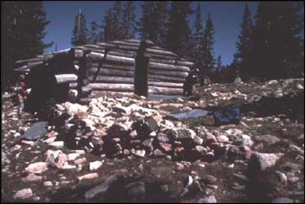
Home life at Johnson Lake Mine was devoid of luxury. The miners lived in a cluster of four log cabins located at the site, the remains of which are relatively intact to this day. The cabins tell their own story. We know the cabins were built in the winter. The tree stumps are chest high, which is where they would be if there had been a foot or two of snow on the ground. Three of the cabins were quite small and were probably used for storage and sleeping. The large cabin has multiple rooms with evidence of a wood stove and the remains of a rodent-proof pantry. Perhaps it served as the office and mess hall. The traces of tent platforms, which are simply cleared rectangular areas on the ground, show where some of the miners slept. The depression of a privy, which is an outdoor latrine, was located near the cabins.
The remnants of trash deposits near the cabins provide clues as to what the miners ate and drank. The bottles and cans that were found show that the miners consumed liquor and ate a diet of meat, lard, sardines, and tuna, among other things. The workers cooked their food in a cast iron stove and may have served it in earthenware bowls. They drank coffee and canned milk, and chewed tobacco or rolled their own cigarettes, as proved by the concentration of about fifty tobacco cans found in the area.
Questions for Reading 3
1) Why was Alfred Johnson's application for mining and power rights in Snake Creek Canyon opposed?
2) What are some of the dangers of mining life?
3) Make a list of pros and cons for heading out West to work in the mines. Would you want to travel to a place like Nevada to strike it rich? Why or why not?
Reading 3 was compiled from Susan J. Wells, Archeological Investigations at Great Basin National Park: Testing and site Recording in Support of the General Management Plan (Tucson: Western Archeological and Conservation Center, 1993); Susan J. Wells, Archeological Survey and Site Assessment at Great Basin National Park (Tucson: Western Archeological and Conservation Center, 1990); Robert B. Gordon and Patrick M. Malone, The Texture of Industry: An Archeological View of the Industrialization of North America (New York: Oxford University Press, 1994); and Susan Wells, "Johnson Lake Mine" National Register of Historic Places Registration Form (Washington, D.C.: U.S. Department of the Interior, National Park Service, 1995).
Determining the Facts
Reading 4: Modern Archeology at Johnson Lake Mine
When a group of people abandons a place where they once lived and worked, they may leave behind many things. "Material culture" or "artifacts" like parts of the buildings they lived in, the objects and machines they once used, or a garbage dump may remain today from peoples of the past. Photographs, diaries, or ledgers may also be recovered through painstaking work. Historical archeologists study all these items (both written records and non-written artifacts) to learn about the people that left these things behind. In contrast, historians study primarily written records, and prehistoric archaeologists are often limited to studying just the artifacts.
Historical archeology also can tell us about people whose history was not recorded or written down. Sometimes artifacts are the only source of information we have of how groups of people lived in the past. On the other hand, sometimes even when we have written records, the artifacts tell a very different story about how people lived in the past.
At Johnson Lake Mine, few written records of how the mine operated, and how the miners lived and worked, have been found. Further complicating investigations, a snowslide descended upon Johnson Lake Mine in the winter of 1935, damaging many of the mine's structures and closing the mine from further production. The trash deposits at Johnson Lake Mine act as a time capsule for archeologists to study so that questions can be answered and some of the mystery of how the mine was run and how these people lived can be solved. Because of the snowslide, archeologists know that the artifacts reflect the mine's history before 1935.
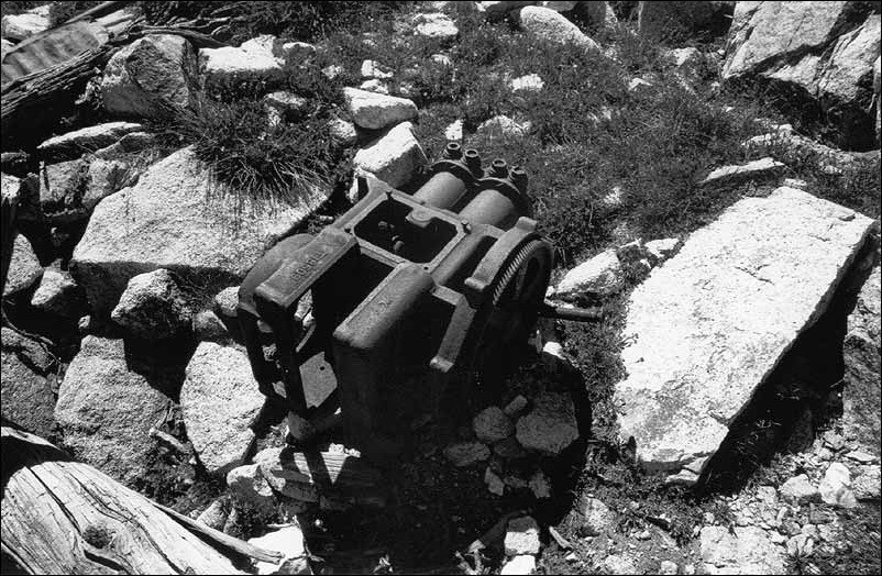
Archeologists at Johnson Lake Mine looked at the mine's remains to come to conclusions about how it operated. They found, for instance, what is left of a cable tramway that traveled from the adit (the horizontal opening of the mine) to a tramway terminal building near the lake. The miners placed the ore in large barrels that traveled down the mountain on a tramway cable operated by a large "Beaver" brand flathead motor. Mules then carried the ore to the gravity concentration mill. The mill was built into the slope to take advantage of a drop-off and to incorporate a huge boulder supporting the heavy milling equipment. The system also took advantage of gravity by having ore enter from the road into the mill's second story and exiting out the rear of the lower story.
Once at the mill, the surrounding rock of the ore was broken or crushed to release the metal deposits. The mill was probably run by water-power or by a steam engine. The route of a one inch diameter metal pipe, assumed to be a water pipe, was traced from Johnson Lake to the mill along the road. Tungsten is fairly easy to mill and concentrate because it is a heavy mineral. The process is entirely mechanical. The ore is crushed, screened to proper size and passed over vibrating tables to separate the heavy tungsten from the waste material.
Because the location of Johnson Lake Mine was so remote, the concentrated tungsten ore had to be transported by mule or wagon 70 miles east to the Union Pacific railhead at Frisco, Utah for export to a factory or steel mill. A connection between the mine and the town of Milford, Utah, located east of Frisco, was confirmed by a sheet of corrugated metal roofing stenciled with the name "Jefferson Metal, Co., Milford, UT" that forms part of the roof in the large log cabin at Johnson Lake Mine.
Archeologists have recovered other information providing clues about the lives of the miners. For example, next to the mill building there is a small building with a very low roof, which suggests that it served as a stable for mules. They also found the remains of a corral nearby and recovered horseshoe and muleshoe nails, and leather straps. Other artifacts recorded by archeologists at the Johnson Lake Mine site include an old canvas hose, buckets, oil cans, wire, nuts, bolts, washers, screws, and bits of rubber. These small artifacts give archeologists clues about what kinds of machinery may have been at the mine. Most of the large, identifiable pieces of equipment have been salvaged for use at other mines, been sold for scrap metal, or been collected by souvenir hunters.
Many items associated with clothing helped archeologists determine what the miners wore and what periods of time the site may have been used. They recorded things like rivets, buttons, parts of leather shoes, gloves, clothing fasteners, and boot buckles. Although the actual clothing material has long since rotted, archeologists can piece together the fragmentary evidence to get an idea about the miners' style of clothing. There was not much remarkable about these artifacts at Johnson Lake Mine, but sometimes you can tell if people living at a site included women, children, or people from a particular ethnic group if you find fancy or unusual clothing fastners such as buckles, buttons, or rivets.
Without archeology we might not know much about how the miners at Johnson Lake Mine operated the mine and what their daily lives were like. Using archeological skills to examine the evidence, we can study what they ate, where they slept, what tools they used, how they worked, and what "treasures" they may have left behind.
Questions for Reading 4
1) How was tungsten milled and concentrated at Johnson Lake Mine? Where was it sent after treatment?
2) Make a list and describe what archeological evidence has been discovered at Johnson Lake Mine. How have these artifacts and structures helped archeologists interpret what happened there?
3) Why has archeology been particularly important in studying Johnson Lake Mine?
4) How might the situation at Johnson Lake Mine have been different if the snowslide had not occurred in 1935? Keep in mind that this took place not long before the onset of the World War II.
Reading 3 was compiled from Susan J. Wells, Archeological Investigations at Great Basin National Park: Testing and site Recording in Support of the General Management Plan (Tucson: Western Archeological and Conservation Center, 1993); Susan J. Wells, Archeological Survey and Site Assessment at Great Basin National Park (Tucson: Western Archeological and Conservation Center, 1990); Robert B. Gordon and Patrick M. Malone, The Texture of Industry: An Archeological View of the Industrialization of North America (New York: Oxford University Press, 1994); and Susan Wells, "Johnson Lake Mine" National Register of Historic Places Registration Form (Washington, D.C.: U.S. Department of the Interior, National Park Service, 1995).
Visual Evidence
Photo 1: "Beaver" brand flathead motor, Johnson Lake Mine.
National Park Service, Western Archeological and Conservation Center Photo
Questions for Photo 1
1) Based on what you learned in Reading 4, what was the motor used for?
2) How did finding this equipment help archeologists learn about the mining process? If needed, please refer to Reading 4.
Visual Evidence
Drawing 1: Overall map of the Johnson Lake Mine complex.
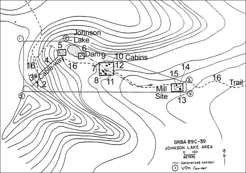
Drawing 1 Key:
|
1. Adit |
9. Cabin 3 |
Drawing 1 shows the mining complex and the topography of the site. The closer the topographic lines are to one another, the steeper the terrain. The map also shows the location of the old water pipeline, which ran from Johnson Lake to the mill.
Questions for Drawing 1
1. Looking at the topographic lines, where do you think the 1935 snowslide originated from that damaged the mine beyond repair?
2. What is the advantage of placing the mill downhill from the lake?
3. Locate the adit. What is it? Why is a tram needed to transport its contents? Please refer to Reading 4 if necessary.
4. Describe the mining process at Johnson Lake Mine. Does this drawing help you better understand how the process worked? Why or why not?
Visual Evidence
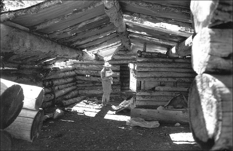
Photo 2: View of interior cabin at Johnson Lake Mine Historic District.
(National Park Service, Western Archeological and Conservation Center Photo)
These are the remains of the largest log cabin at Johnson Lake Mine. Susan Wells, a National Park Service archeologist, appears in the photo. The cabin was divided into two rooms and has a rodent-proof pantry (right) lined with galvanized, corrugated sheet metal. This cabin may have been a community structure, possibly the kitchen and dining hall.
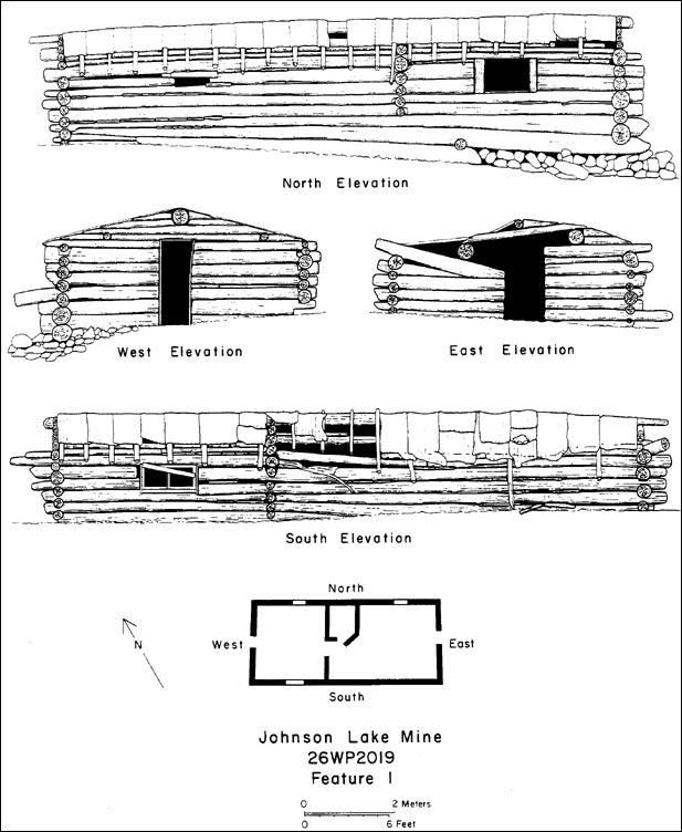
(National Park Service, Western Archeological and Conservation Center, Drawing by Ronald Beckwith)
This is a drawing of the cabin pictured in Photo 2.
Questions for Photo 2 & Drawing 2
1. Examine Photo 2. What do you think this person is doing?
2. If you were an archeologist, what kind of questions would you ask when examining a site?
3. How might documenting the remains of the worker's cabins help one understand their living conditions?
4. Why do you think a rodent-proof pantry was necessary?
5. Using the scale and small model of the cabin in Drawing 2, approximately how big was this cabin?
6. Based on Photo 2 and Drawing 2, what are your impressions of the living conditions at Johnson Lake Mine?
Visual Evidence
Drawing 3: Detail map of the trash and rubble scatter from the collapsed cable-way terminal building.
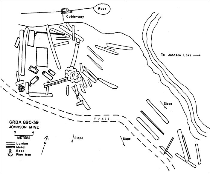
(National Park Service, Western Archeological and Conservation Center Drawing)
Tourists and visitors often steal artifacts from archeological sites. Part of an archeologist's job is to study artifacts and interpret them to the public. If all of the artifacts were taken, what would be left to tell us about the miners and their families, who lived, worked, and died at Johnson Lake Mine? The artifacts and information that we get from them belong to all of us. When artifacts are stolen and their provenience (the information about the location where an artifact was found) is lost, it is lost forever.
Questions for Drawing 3
1. Examine Drawing 3. Note the distance from the trail to the trash and rubble scatter. Do you think it is a good idea to have the trail so close to the archeological artifacts at Johnson Lake Mine? Why or why not?
2. Compare Drawing 1 and Drawing 3. Locate the trail in both drawings. How might Johnson Lake Mine have been affected by the location of the trail?
3. Assuming the point of view of an archeologist, and keeping in mind that archeological artifacts are often stolen from sites, how might the Johnson Lake Mine site be affected by the public?
Putting It All Together
In this lesson, students explore both how tungsten was mined and used at the turn of the 20th century and also how archeologists piece the past together from artifacts and other archeological evidence. The following activities will help them apply what they have learned.
Activity 1: The Archeological Record
Have each student pick one or several objects that they think will be crucial for future archeologists to understand our society. Have the student make a class presentation explaining why they chose what they did. What possible meanings might archeologists attribute to their artifact? Will it be obvious what the objects were used for, or will archeologists have trouble determining their use? What if only part of an object was found, rather than the whole item? If possible, invite a local archeologist and have him/her talk to the class about archeology in the community.
Activity 2: The Mind of the Archeologist/The Mind of the Public
Divide the class into two. The first group, the "archeologists" should lead a debate concerning why it might be important to restrict public access to archeological sites. The other side of the debate, the "public" should argue the importance of allowing public access to archeological sites.
Activity 3: The Puzzle
At most, archeologists can expect to find 10 percent of the material culture (that is the artifacts and structural remains) at typical sites more than 1,000 years old. Bring a 100- piece jigsaw puzzle to class and do not let students see the outside picture on the box. Depending on the size of your class, have each student pick out 10 random pieces and attempt to assemble them in some sort of order. Ask them to suggest what the larger puzzle may be based on the information they have available. If they are lucky they might see something identifiable such as a horse's nose or the face of the person in the picture. It's possible they will choose pieces that are less telling, such as the solid blue of sky. How many more pieces do they need to draw out of the bag/box to form a partial picture of the puzzle? Have a class discussion on how hard it is to get a good idea of what is going on with only 10 percent of the information.
Activity Four: Life During WWI
Have students research events in their community during World War I and how their community supported the war effort. Were there any industries directly related to the war effort? If so, what were they? What impact did they have? What happened to them after the war? Do any buildings or sites remain today from these industries? An alternate activity would be to have students conduct an oral history on the life of a specific person who lived through WWI or WWII. What was their life like back then? Where did they live? What did they eat? What did they wear? Where did they work and play? What did they talk about? Have the students make a class presentation on their findings.
Johnson Lake Mine: Mining for Tungsten in Nevada's Snake Range--
Supplementary Resources
By looking at Johnson Lake Mine: Mining for Tungsten in Nevada's Snake Range, students understand what tungsten is and how it was used, how it was mined, and how archeologists are able to piece together the past from artifacts and archeological evidence. Those interested in learning more will find that the Internet offers a variety of materials.
Great Basin National Park
Great Basin National Park is a unit of the National Park System. Visit the park's Web pages for more information on the park's biology, history and culture, and geology.
Three Historic Nevada Cities: Reno, Virginia City, and Carson City
The National Register of Historic Places' on-line travel itinerary, Three Historic Nevada Cities, provides information on 57 historic places listed in the National Register associated with the unique history of this area. The three cities were established after the discovery of the Comstock Lode in 1859, making mining integral to the area's development. Virginia City, in particular, is known for the Comstock Mining District, which produced a spectacular amount of wealth.
Library of Congress: American Memory Collection
Visit the American Memory Collection's History of the American West 1860-1920 for a collection of photographs illuminating many aspects the mining experience among other topics.
Early Radio History
During World War I, the United States government assumed control of most of the U.S. radio industry, in addition to the telegraph and telephone lines. It also gained access to all radio patents, which meant the military could use the best equipment that had been developed by the various competing companies. In this report by George O. Squier, Major General, Chief Signal Officer of the Army, October 15, 1919, he discusses the advancements in radio communication due to the Vacuum Tube, one type being the Tungsten-filament vacuum tube.
Society for American Archeology
The Society for American Archeology (SAA) is an international organization dedicated to the research, interpretation, and protection of the archeological heritage of the Americas. Included on the website is an extensive education section that provides Guidelines for the Evaluation of Archeology Education Materials among its many resources.
Society for Historical Archeology
The Society for Historical Archeology (SHA) is the largest scholarly group concerned with the archeology of the modern world (A.D. 1400-present). The main focus of the society is the era since the beginning of European exploration. Included on the website are a variety of online publication links and research tools.
For Further Reading
Students and educators wishing to learn more about the mining industry at the turn of the 20th century may want to read: Robert B. Gordon and Patrick M. Malone, The Texture of Industry: An Archeological View of the Industrialization of North America (New York, NY: Oxford University Press, 1994); Sally Zanjani, The Glory Days in Goldfield, Nevada (Reno: University of Nevada Press, 2002); and Drew Heath Johnson and Marcia Eymann, eds., Silver and Gold: Cased Images of the California Gold Rush (Iowa City, IA: University of Iowa Press for the Oakland Museum of California, 1998).
Tags
- mining
- great basin national park
- nevada
- nevada history
- mining history
- world war i
- industrial history
- archaeological site
- archeology
- archaeology
- national register of historic places
- nrhp listing
- teaching with historic places
- twhp
- gilded age
- early 20th century
- labor history
- science
- great basin national heritage area
- progressive era
- science and technology
- twhplp
