Last updated: March 7, 2024
Article
Mapping an Armory Grounds Tailrace at Harpers Ferry National Historical Park
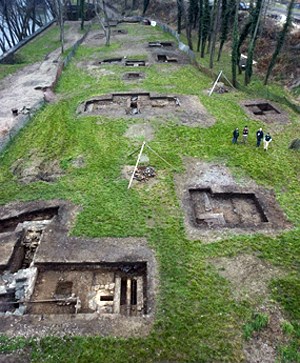
Photo by Robert E. Brzostowski.
A large part of that responsibility falls upon the park Division of Resource Management and the Archeology Program. They are tasked with, among other things, documentation, investigation, and compliance with the laws governing these multi-faceted resources so that the public today and tomorrow can benefit from that shared heritage.
The Archeology Program is involved in an ongoing investigation of the Lower Armory Grounds. This land, acquired in 2001 from CSX Corporation, contains the remains of the second national armory commissioned by the United States in 1798. An important part of this land acquisition was gaining access to the remnants of the infrastructure that was integral to the operation of the Armory. One such feature is the tailrace tunnels. The investigation of the armory grounds and a tailrace highlights the park's devotion to fulfilling its obligation of both understanding its resources in order to better protect them and to present that information to the public for a more comprehensive experience of this facet of American history.
NPS photo.
History of Harpers Ferry
Harpers Ferry began in 1733 as little more than a river crossing when Peter Stephens settled there and offered a needed service in manning a ferry. His control of the point of land at the confluence of the Potomac and Shenandoah Rivers ended in 1747 when Robert Harper purchased it from him. Harper formally acquired the land via an official grant in 1751. He saw the potential for both a continued ferry system and mills powered by the abundant water to process grains and cut wood. Harpers Ferry's economy continued in this vein until the 1790's when the fledgling United States government, through the urging of George Washington, purchased land for a second national armory, the first being in Springfield, Massachusetts. Two land grants in 1796 and 1797 secured a total of 428 acres.
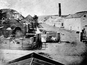
Construction began in 1799 with the establishment of a dam on the Potomac River and an adjacent canal to provide water to the armory. This was followed by multiple shops to manufacture weapons. Manufacturing equipment was powered by water from the canal delivered through tail races that ran under buildings and discharged into the Potomac River. Production got underway in 1801. As needs increased, the Armory expanded, going through several phases of major construction and refurbishment. During this time, the canal with its associated tailraces remained largely unchanged.
The armory's close proximity to the U.S. capital, its position at the confluence of two great rivers, and the restricted passage through the valleys generated by this geology proved to be both a boon and a problem. Two major transportation systems, the Chesapeake and Ohio Canal Company and the B & O Railroad, used the Potomac valley bottom, passing next to the armory and providing ready transport and supply lines. Harpers Ferry soon became an industrial center. The main musket factory was followed by Hall's Rifle Works on Virginius Island in the Shenandoah River, adjacent to the town.
As a central hub, the town also drew unexpected and dangerous attention. In 1859, John Brown sought to draw attention to slavery by raiding the Armory. In 1861, with the secession of Virginia from the Union, their soldiers marched into Harpers Ferry. Seeing that preventing capture was impossible, the Federal officer in charge of guarding the armory ordered the buildings set afire before abandoning it. Southern Forces later looted the Armory leaving the buildings mostly intact but removing manufacturing equipment. During the war, Harpers Ferry changed hand multiple times. The Union, however, dominated control and re-utilized the Armory buildings as a supply depot.
NPS drawing.
From 1861 onward, buildings of the armory grounds were variously leveled until only a 90 foot tall smoke stack associated with the smith and forging shop remained. This was toppled in 1892, thereby removing the last most visible vestige of the armory. Interest in the armory subsequently focused on the written and photographic historical record. In 2005 the Archeology Program at Harpers Ferry NHP brought new attention to the armory through a series of excavations at the smith and forging shop and the 1841 warehouse. This has been followed most recently by an investigation into Armory Street and an exploration of the tailrace beneath it.
Necessary to any facility relying on waterpower to run machinery, tailraces are rarely seen as noteworthy features requiring intense study. They are simply channels for directing water away from a production facility or mill after passing through a water wheel or turbine, thereby moving the wheel to operate other machinery. However, as past technologies become forgotten arts, these architectural vestiges contain substantial information to document those skills and periods of history. It is with these thoughts in mind that Harpers Ferry NHP Archeology Program staff documented a tailrace located within the park.
NPS photo.
Exploring the 19th Century Tailrace
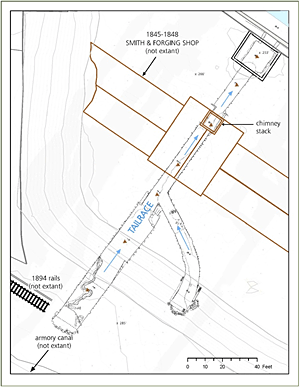
The tailrace on the Harpers Ferry Armory grounds may be unique in being one of the best preserved examples of an industrial raceway tunnel within Federal possession. Its uniqueness was also the cause for concern. Under OSHA regulation 29 CFR 1910, the tunnel is a confined space, requiring a permit, such as MSA Bulletin 5555-58, and certain safety precautions prior to entry. With the help of V. E. Sankbeil, Department of Veteran's Affairs, the Friendship Fire Company of Harpers Ferry, and NPS personnel, park archeologists met the requirements for authorized entry. They spent four days in October 2011 mapping and photographing the tailrace tunnel. By the end of the project, the team had successfully documented the tailrace despite mud, water, and confined spaces.
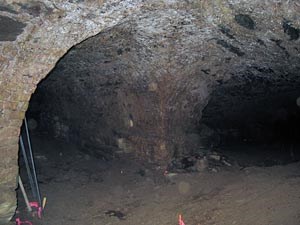
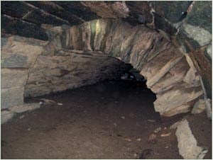
Exploration of the tunnel revealed a number of fascinating construction features. NPS archeologists found that the tunnel is not simply a single shaft but is, in fact, comprised of two sections forming a “Y” shape. The main shaft extends 183 feet from its opening to a point where the B&O Railroad crew intentionally collapsed it as part of their 1892-94 berm construction. From its intersection with the main tunnel at 86 feet in, the secondary shaft runs another 70 feet until it, too, ends at a deliberate collapse. Unlike the main shaft, though, this secondary tunnel has a curved portion facilitating its linking with the larger tunnel. Based on this evidence, the secondary tunnel may represent an earlier construction phase.
NPS photo.
The tunnels were constructed as a series of arched vaults that document the complex evolution of the tailrace. Rough-hewn shale is the predominant construction material for both tunnels, owing to its abundant occurrence as natural outcrops throughout Harpers Ferry. There were, however, three instances of the use of brick for vaults. Two of these brick vaults correspond to the locations of former armory shops, while the third was used to enable the curve in the smaller tunnel. Within one vault, two drain holes were discovered, complete with copper gutter spouts. These either directed rain runoff from the above building's roof into the tunnel or carried away the water used to wet polishing stones in the shop. Another vault, this one in the smaller tunnel, contains a shale slab with a circular hole cut into it which is situated atop a 1 foot by 1 foot brick opening. Its function has yet to be understood.
Multiple beam recesses were also noted during the mapping. Most are situated in the shale walls of the largest chamber in the main tunnel 2 feet above the current floor surface. Forming a series of 12 paired cavities, these suggest that wooden beams 16 feet in length once spanned this portion of the tunnel for 25 feet of its length. Plaster remnants in individual recesses clearly show the wood grain of the beams. Their purpose at this location remains unknown, but they may have provided scaffolding during tunnel construction or support the shale vault after it was erected. Further down the tunnel, almost to the area of the intentional tunnel collapse, two more beam recesses were noted. These were nearly 12 inches square, twice the size of the aforementioned beams. Their proximity to the end of the tunnel, and to the location of the actual water wheel, suggests that they were part of the system used to mount the wheel in place.
Perhaps the most important finding of the investigation is that this tunnel is intact and stable. The other six tailraces may also be well preserved despite being no longer accessible due to sedimentation. The integrity of this open tunnel is a tribute to the expertise and skill of the engineers and laborers who erected it in the 19th century. Discovering that the tailrace forms a “Y” further tells us that some of the other tunnels may have had similar splits. This, in turn, suggests that the Armory Shops had supplementary water power potential not directly inferred from the reports by the Superintendents who ran the facility.
Further work, however, remains to be done to understand what the tunnel can tell us about the armory and its organization. Features such as the tailrace tunnel demonstrate the importance of documenting the cultural resources at Harpers Ferry NHP. The results of the investigation will be incorporated into the interpretation of the park. It will offer visitors a glimpse of America's industrial heritage of the 1800s without risking their safety by venturing into the tunnel themselves or causing harm to the sensitive archeological features and wildlife habitat within. Nevertheless, with only one tunnel open and the others already silted by the river, this is inevitably a race against time to document these tunnels before they are erased, both from the landscape and our shared cultural memory.
By J.P. Ebersole, Archeologist, Harpers Ferry National Historical Park
