Last updated: May 5, 2020
Article
Why Glaciers Collapse

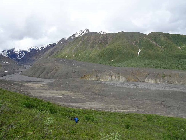
Photo courtesy of Mylène Jacquemart, CU Boulder
A large debris slide was noted in Wrangell-St Elias National Park and Preserve. But when geologists went to investigate, they noticed that it wasn't a regular landslide: a large portion of the upstream glacier was missing. More than a quarter-mile section of the tongue on Flat Creek Glacier broke off and sent ice, rock, and water sliding nearly 7 miles down valley.
This wasn't triggered by an earthquake--there was no seismic activity in the area at the time--so what caused such a dramatic release of rock and ice? What they learned was, the lower part of the glacier's tongue was thin and firmly frozen to the glacial bed. As ice and meltwater from farther upstream flowed down toward the frozen tongue, they were blocked. The trapped ice and water created an ice bulge on the glacier's tongue that was about 230 feet high. As the subglacial water pressure increased, it eventually caused the bulge to collapse.
We know that glaciers around the world are diminishing and that ice is melting at a faster rate as the air warms. But this event showed that we need to be aware of other hazards like this large-scale collapse that can impact a much larger area. Luckily, Flat Creek Glacier is remote. While a section of 400-year-old forest was destroyed, no one was harmed. In Russia and Tibet, glacial collapses have claimed lives.
What drives large-scale glacier detachments? Insights from Flat Creek glacier, St. Elias Mountains, Alaska
Abstract
Two large-scale glacier detachments occurred at the peaks of the 2013 and 2015 CE melt seasons, releasing a cumulative 24.4–31.3 × 10⁶ m3 of ice and lithic material from Flat Creek glacier, St. Elias Mountains, Alaska. Both events produced highly mobile and destructive flows with runout distances of more than 11 km. Our results suggest that four main factors led to the initial detachment in 2013: abnormally high meltwater input, an easily erodible glacier bed, inefficient subglacial drainage due to a cold-ice tongue, and increased driving stresses stemming from an internal redistribution of ice after 2011. Under a drastically altered stress regime, the stability of the glacier remained sensitive to water inputs thereafter, culminating in a second detachment in 2015. The similarities with two large detachments in the Aru mountains of Tibet suggest that these detachments were caused by a common mechanism, driven by unusually high meltwater inputs. As meltwater production increases with rising temperatures, the possible increase in frequency of glacier detachments has direct implications for risk management in glaciated regions.
Jacquemart, M., M. Loso, M. Leopold, E. Welty, E. Berthier, J. S. S. Hansen, J. Sykes, and K. Tiampo. 2020. What drives large-scale glacier detachments? Insights from Flat Creek glacier, St. Elias Mountains, Alaska. Geology doi: https://doi.org/10.1130/G47211.1
