Part of a series of articles titled The Cultural Landscape of Fort Vancouver National Historic Site.
Article
The Cultural Landscape of Fort Vancouver National Historic Site: National Park Service, 1948-1996

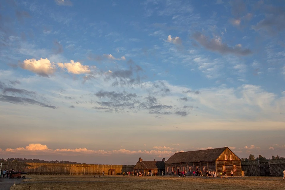
Photo by Christopher Communications
Excerpted from Vancouver National Historic Reserve Cultural Landscape Report. For more information on this report, email us.
After the conclusion of World War II in 1945, the size of the military force at Vancouver Barracks was significantly reduced, and its operations were limited primarily to the reserve activists. By January 1946, the Army Transportation Corps considered Vancouver Barracks excessive with respect to national military needs, and from that day forward, the Barracks ceased to be an active military installation.
In early spring 1946, the military reserve was turned over to the custodial supervision of the Corps of Engineers, who then appointed the War Assets Administration as trustee to the Barracks. The purpose of the Assets Administration was to distribute the surplus of the Vancouver Barracks property. The northern half of the military reserve was incorporated into the City of Vancouver and subsequently became part of urban development. When the War Assets Administration transferred the southeastern portion of the site to the City of Vancouver for its use as a municipal airport, conflicting protests arose from both state and local historical societies who tried to lobby legislation to gain control of the site.
Meanwhile the army was withdrawing from many areas of the site. In 1947 sixty-four acres of Vancouver Barracks, or the core Barracks area in the south part of the military reserve, were restored as a military post and were designated headquarters for Army Reserve training in the Pacific Northwest.
The National Park Service (NPS) also wanted to seek designation of the former HBC site as a national monument. The National Park Service’s interest stemmed from the War Department’s 1915 designation of the HBC site as a national monument under the Antiquities Act of 1906. This recognition was either forgotten or withdrawn, and nearly ten years passed before Congress approved the activity of restoring the stockade. In 1925 and later in 1938, two laws passed that authorized the re-construction of the stockade.
Serious interest in the reconstruction of the stockade dated back to 1908 when local historians and dedicated citizens staked out the area of the HBC stockade based on the 1854 Bonneville plans. However, it would not be until almost forty years later that the realization of the dream took form. Throughout the years, various attempts were advanced to legislate protection and preservation of the site, commencing with the unrealized designation of the site as a national monument in 1915. In March 1925, the centennial year of the HBC fort’s establishment, Calvin Coolidge signed a bill authorizing the Secretary of War to allow the reconstruction of the fort stockade; however, no funds were appropriated to support the reconstruction. And in the 1930s, two unsuccessful bills were introduced to Congress to appropriate funds for rebuilding of the stockade. By 1936 the National Park Service teamed up with the Vancouver Chamber of Commerce to survey the location of the fort, and within two years Congress authorized Vancouver to build a historical monument on site.
In 1947 the Washington State Legislature passed a bill recommending the establishment of Fort Vancouver National Monument. In June of the same year, funds were appropriated by Congress to fund archeological excavations of the area of the fort. The National Park Service sponsored an archaeological dig as part of its historic research into the Hudson’s Bay Company’s presence on the site. NPS archaeologist Lois Caywood located the corners of the stockade in Fall 1947, and an historical investigation commenced on the interpretation of the physical structure.
Finally, within a year of NPS archaeological studies, the portion of the site that formerly contained the HBC stockade was officially recognized. In 1948 Congress established Fort Vancouver National Monument, which included approximately ninety acres of the Old Fort Plain. The first park superintendent arrived in 1951, and Secretary of the Interior Douglas McKay formally dedicated the national monument in 1954.
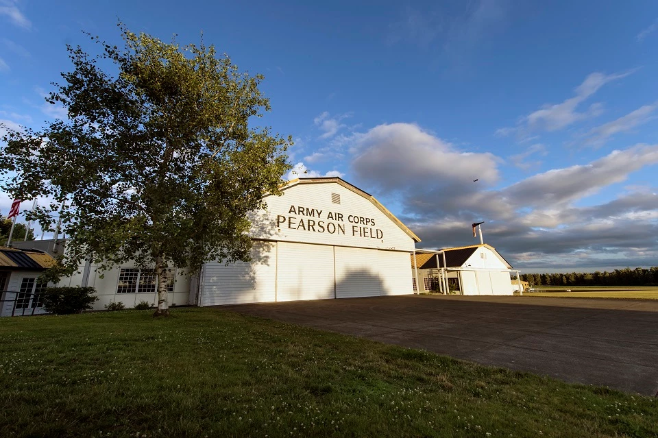
As aviation activity decreased after the war, the U.S. Army announced that Pearson Field was surplus property. The City of Vancouver was permitted to join the municipal fields with the army airfields, and the combined facility was renamed Pearson Airpark. Later when Fort Vancouver National Monument was established, the City of Vancouver and the National Park Service reached an agreement that the airport was granted an easement on the former HBC site.
Despite fiscal setbacks and tenant problems that almost closed the airpark three times, the state prohibited the city from issuing bonds to facilitate improvements. In 1964 the airpark, in an attempt to improve revenue and business, extended the lower runway more than an additional eight hundred feet to the west. Throughout the 1960s negotiations between the National Park Service and the owner of Pearson Airpark were attentive to the sale of the western portion of the airpark. Aviation restrictions impeded work on the HBC fort stockade, hence NPS wanted to purchase this land to complete reconstruction of the HBC stockade. Finally the National Park Service acquired the western half of the airpark in 1972 with an allowance for the City of Vancouver to continue to use the site.
Various land purchases and exchanges occurred in the ensuing decades to expand or augment the existing national monument boundary or to facilitate cooperative agreements with the multiple agency landowners. The National Park Service, the City of Vancouver, Burlington Northern Railroad (successor to SP & S Railway), Federal Aviation Agency, Washington State Department of Transportation all have had a vested (and sometimes conflicting) interest in the site over the last several decades.
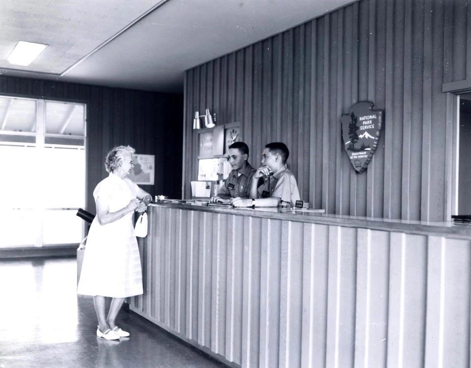
In June 1961 Presidential approval of a Congressional Act changed the name of the site to Fort Vancouver National Historic Site, and removed some of the restrictions on NPS management of the site. Later that same year, a visitor center for the historic site was constructed on the east end of Vancouver Barracks’ former Parade Ground. Reconstruction of the fort stockade was completed in the early 1970s, and a program to reconstruct several HBC stockade buildings was instituted at this time.
Administrative and Political Context
After the conclusion of World War II in 1945, the size of the military force at Vancouver Barracks was significantly reduced, and its operations were limited primarily to the reserve activists. By January 1946, the Army Transportation Corps considered Vancouver Barracks excessive with respect to national military needs, and from that day forward, the Barracks ceased to be an active military installation.
In early spring 1946, the military reserve was turned over to the custodial supervision of the Corps of Engineers, who then appointed the War Assets Administration as trustee to the Barracks. The purpose of the Assets Administration was to distribute the surplus of the Vancouver Barracks property. The northern half of the military reserve was incorporated into the City of Vancouver and subsequently became part of urban development. When the War Assets Administration transferred the southeastern portion of the site to the City of Vancouver for its use as a municipal airport, conflicting protests arose from both state and local historical societies who tried to lobby legislation to gain control of the site.
Meanwhile the army was withdrawing from many areas of the site. In 1947 sixty-four acres of Vancouver Barracks, or the core Barracks area in the south part of the military reserve, were restored as a military post and were designated headquarters for Army Reserve training in the Pacific Northwest.
The National Park Service (NPS) also wanted to seek designation of the former HBC site as a national monument. The National Park Service’s interest stemmed from the War Department’s 1915 designation of the HBC site as a national monument under the Antiquities Act of 1906. This recognition was either forgotten or withdrawn, and nearly ten years passed before Congress approved the activity of restoring the stockade. In 1925 and later in 1938, two laws passed that authorized the re-construction of the stockade.
Serious interest in the reconstruction of the stockade dated back to 1908 when local historians and dedicated citizens staked out the area of the HBC stockade based on the 1854 Bonneville plans. However, it would not be until almost forty years later that the realization of the dream took form. Throughout the years, various attempts were advanced to legislate protection and preservation of the site, commencing with the unrealized designation of the site as a national monument in 1915. In March 1925, the centennial year of the HBC fort’s establishment, Calvin Coolidge signed a bill authorizing the Secretary of War to allow the reconstruction of the fort stockade; however, no funds were appropriated to support the reconstruction. And in the 1930s, two unsuccessful bills were introduced to Congress to appropriate funds for rebuilding of the stockade. By 1936 the National Park Service teamed up with the Vancouver Chamber of Commerce to survey the location of the fort, and within two years Congress authorized Vancouver to build a historical monument on site.
In 1947 the Washington State Legislature passed a bill recommending the establishment of Fort Vancouver National Monument. In June of the same year, funds were appropriated by Congress to fund archeological excavations of the area of the fort. The National Park Service sponsored an archaeological dig as part of its historic research into the Hudson’s Bay Company’s presence on the site. NPS archaeologist Lois Caywood located the corners of the stockade in Fall 1947, and an historical investigation commenced on the interpretation of the physical structure.
Finally, within a year of NPS archaeological studies, the portion of the site that formerly contained the HBC stockade was officially recognized. In 1948 Congress established Fort Vancouver National Monument, which included approximately ninety acres of the Old Fort Plain. The first park superintendent arrived in 1951, and Secretary of the Interior Douglas McKay formally dedicated the national monument in 1954.
As aviation activity decreased after the war, the U.S. Army announced that Pearson Field was surplus property. The City of Vancouver was permitted to join the municipal fields with the army airfields, and the combined facility was renamed Pearson Airpark. Later when Fort Vancouver National Monument was established, the City of Vancouver and the National Park Service reached an agreement that the airport was granted an easement on the former HBC site.
Despite fiscal setbacks and tenant problems that almost closed the airpark three times, the state prohibited the city from issuing bonds to facilitate improvements. In 1964 the airpark, in an attempt to improve revenue and business, extended the lower runway more than an additional eight hundred feet to the west. Throughout the 1960s negotiations between the National Park Service and the owner of Pearson Airpark were attentive to the sale of the western portion of the airpark. Aviation restrictions impeded work on the HBC fort stockade, hence NPS wanted to purchase this land to complete reconstruction of the HBC stockade. Finally the National Park Service acquired the western half of the airpark in 1972 with an allowance for the City of Vancouver to continue to use the site.
Various land purchases and exchanges occurred in the ensuing decades to expand or augment the existing national monument boundary or to facilitate cooperative agreements with the multiple agency landowners. The National Park Service, the City of Vancouver, Burlington Northern Railroad (successor to SP & S Railway), Federal Aviation Agency, Washington State Department of Transportation all have had a vested (and sometimes conflicting) interest in the site over the last several decades.
In June 1961 Presidential approval of a Congressional Act changed the name of the site to Fort Vancouver National Historic Site, and removed some of the restrictions on NPS management of the site. Later that same year, a visitor center for the historic site was constructed on the east end of Vancouver Barracks’ former Parade Ground. Reconstruction of the fort stockade was completed in the early 1970s, and a program to reconstruct several HBC stockade buildings was instituted at this time.

NPS Photo
In the 1980s and 1990s, increased awareness and appreciation of the site’s rich history beyond the Hudson’s Bay Company story prompted an initiative to expand the site’s physical and programmatic parameters. In 1993 Vancouver Historical Study Commission completed a study entitled Vancouver National Historic Reserve Feasibility Study and Environmental Assessment. The study recommended the establishment of the Historic Reserve to protect, preserve, enhance, and enjoy the area’s significant historic, cultural, natural, and recreational resources. The Commission assessed the historic resources of the immediate vicinity, determined the boundaries of the Historic Reserve, and recommended the cooperative management strategy that is currently in place.
As a result of this study, Vancouver National Historic Reserve was established by Congress in 1996 in recognition of various nationally significant events that have occurred on site, most notably the Hudson’s Bay Company’s activities between 1824 and 1860, and the military activities of U.S. Army from 1849 to 1946. The Reserve also encompasses other important events on site, including aviation history in the form of Pearson Field, Civilian Conservation Corps activities, Spruce Mill and Kaiser Shipyards industrial production, National Park Service historic preservation activities, and American Indian traditional practices.
Multiple owners/managing agencies have control over various portions of the Historic Reserve; however, the entire Reserve is jointly managed by the Reserve Partners who represent these various agencies. Currently, the National Park Service owns Fort Vancouver National Historic Site, which includes the Visitor Center area, the Parade Ground, the HBC Fort and surrounding environs, and part of the waterfront. The City of Vancouver manages Officers’ Row and the West Barracks, as well as Old Apple Tree Park, the eastern portion of Pearson Airpark, the Water Resources Center, and portions of the waterfront. The U.S. Army Reserve still occupies the East Barracks but is considering relocation of its facilities. The State of Washington owns the SR 14 right-of-way and I-5 interchange. The Reserve Partners’ cooperative management model is essential to ensure effective preservation and management of the historic resources.

NPS Photo
Site Description
Significant events occurred during this period that greatly impacted existing spatial configurations and built forms in the landscape. The U.S. Army’s decommissioning of Vancouver Barracks as an active military post prompted a series of major changes. First, the military reserve was effectively reduced to half, and the northern lands were absorbed by City of Vancouver development. The U.S. Army presence continued in the form of the Army Reserve, but military activities were concentrated in the Barracks area.
The Army’s withdrawal from most of the site led to the establishment of the HBC site as a National Historic Monument. Eventually Congress designated the site as Fort Vancouver National Historic Monument, later re-named as Fort Vancouver National Historic Site. As a result, the National Park Service implemented several actions to protect and interpret archaeological and cultural resources associated with the Hudson’s Bay Company’s presence on site.
NPS developments during this period included the reconstruction of the HBC fort stockade and structures within the original stockade; construction of a new visitor center, administrative, and maintenance facilities; and the addition of new pathways, minor roads, and parking. Many structures and roads formerly associated with the Vancouver Barracks were removed, and the Parade Ground was reduced by construction of the visitor center complex.
Additional changes to the site included the expansion of Pearson Airpark’s structure and airport runways to the west, as well as developments along the Columbia River shoreline. NPS acquired six and one-half acres along the Columbia River, and permitted the land to the city for use as a public park. The City constructed a public boat launch and park facilities.

NPS Photo by Troy Wayrynen
Landscape Characteristics
Natural Systems and Vegetation
Natural systems and native vegetation were greatly modified in prior periods, and the only remnant of floodplain vegetation occurred in the vicinity of today’s Water Resources Center. Dam construction, dredging, and shoreline armoring heavily impacted the Columbia River waterway and shoreline during this period.
The north half of the Vancouver Barracks that once contained significant stands of mature Douglas fir trees was mostly cleared for new City of Vancouver development, although some centennial trees do still persist today.
New vegetation was planted in the area north of E 5th Street and around the visitor center during this time, including clusters of maples, incense cedars, holly, Douglas fir, and various shrubs. These new plantings effectively enclosed the former open areas southeast and east of the Parade Ground.
The orchard was partially reconstructed north of the stockade, and numerous fruit trees were planted in the vicinity of the southwest portion of the Hudson’s Bay Company gardens site. Planted by the Park Service in 1960– 61, the species of trees planted did not follow any particular historical plan although they included several varieties of apples trees, cherries and plums. The fields and pastures east of the stockade were planted with grass with the addition of a parking lot, which was added to service the newly reconstructed stockade.
Spatial Organization
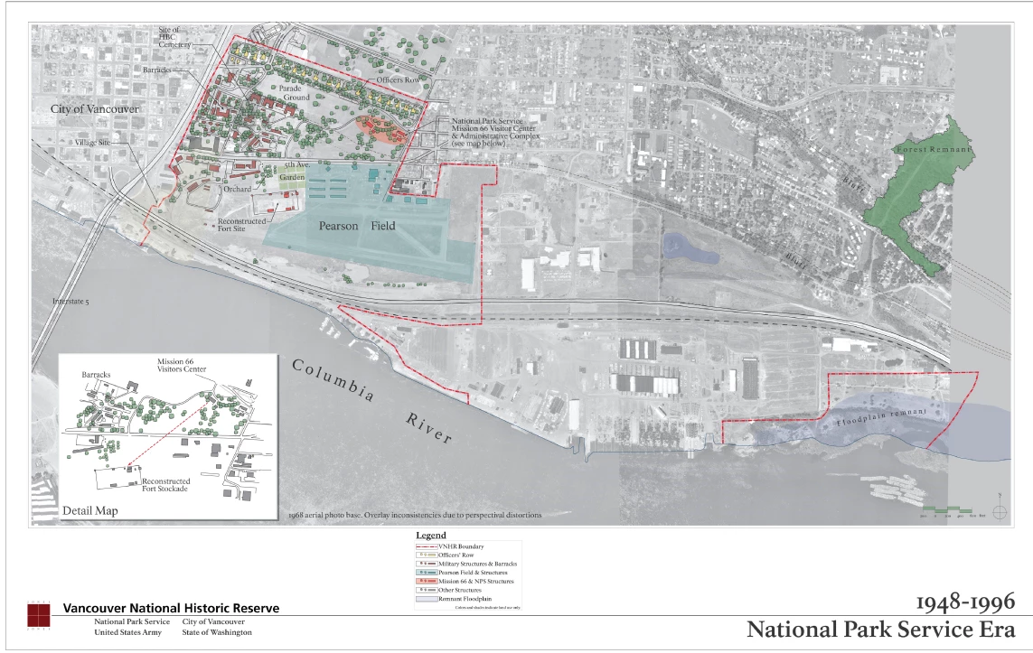
Spatial organization of the site changed quite a bit during this period, although many key features remained from preceding periods. The most significant change was the reduction of military reserve land by more than fifty percent when the U.S. Army declared the site surplus. All site-related activity subsequently shifted to the south part of the former Vancouver Barracks.
The designation of the site as a National Historic Monument spurred a phase of numerous demolitions and new developments. More than half of the Barracks buildings were removed, thereby decreasing the density of structures in the central and west portions of the site. NPS reconstructed the HBC fort stockade and landscape environs in the original location south of E 5th Street, and developed visitor and administrative facilities on the east end of the Parade Ground.
Other land uses were expanded or newly introduced that directly influenced the site’s spatial organization. The waterfront was developed into a public park and boat launch facility. Pearson Airpark expanded its operations westward, creating a paved runway and a series of hangars just east of the fort stockade.
Several road developments, including internal roads and local highways adjacent to the former military post, impacted the site's spatial organization. An entire new road system was constructed in the north portion of the site in association with the conversion of land use to urban development. Highway 99 was widened and reconstructed with an interchange, encroaching upon the west boundary of the former military reserve.
The National Park Service's installation of new plantings created more tree canopy than had historically occurred during the military periods in the areas east and south of the Parade Ground. Additionally, fruit trees were planted north of the reconstructed fort. The physical extent of the Parade Ground's lawn was reduced to accommodate the NPS visitor center.
Land Use
The site’s legacy as a prominent military post for more than one hundred years discontinued during this time, although military activities persisted in the form of the U.S. Army Reserve. This political shift set the stage for preservation efforts, leading to the designation of the site as a National Historic Monument. During this time period NPS activities were focused on archaeological documentation and research, as well as interpretation of the cultural and historic resources for public enjoyment. Reconstruction of the HBC fort scene coupled with a new visitor center were among NPS activities to help interpret the site’s historic significance and educate the public.
Circulation
The internal road structure was modified although key historic roads such as E 5th Street and Grant Avenue remained in place. Roads defining the edges and the division of the Parade Ground were changed or removed. Minor circulation patterns between former Barracks buildings were eliminated. New secondary roads and pedestrian pathways were created to service the new NPS visitor center and the fort stockade.
The late 1950s re-alignment of U.S. Highway 99 and the creation of an interchange with Highway 830 infringed upon the west boundary of the site, and created a barrier between the site and the City of Vancouver. When the road alignment was widened, approximately 150 feet of the site was taken over as right-of-way for the highway.
This action precipitated the removal of several buildings in that area, including all buildings west of the Barnes Hospital. A few short years later in 1964 the highway was reconstructed as Interstate 5. Construction of the State Route 14/Interstate 5 interchange in the southwest corner of the site effectively eradicated the west end of the HBC riverfront complex.
In 1947–48 the Pearson Airpark runways were extended, and the civilian airfield’s runways were connected to the military turf runways. The upper runway crossed the site of the HBC stockade while the lower runway was extended as far as the municipal airport boundary. By late 1948, it was extended an additional 1,800 feet to the west. In addition, a taxi way was built connecting the two runways. By 1955 the upper runway terminated at the edge of the boundary of the Park Service.
Buildings, Clusters, and Small-scale Features
Buildings, clusters, and small-scale features associated with the military reserve were dramatically impacted during this time. More than seventy Barracks buildings in the core reserve area were demolished. Additionally, any structures in the north part of the former military reserve gave way to new city development, although there were few built features as most of this vicinity was historically in open space.
The military buildings that remained extant included: Officers’ Row, the O.O. Howard House, the large residential barracks edging the Parade Ground, the hospital and Red Cross building, the brick duplexes, and various barracks buildings.
New buildings were constructed on the site in connection with the expansion of Pearson Airpark and the establishment of the Fort Vancouver National Historic Monument. Pearson Airpark added several new hangers, administrative offices, and maintenance facilities. The National Park Service developed a visitor center, administrative offices, and maintenance facilities in the northeast portion of the site. The federal agency also re-constructed the HBC fort stockade and several buildings historically contained within the stockade.
Additionally, Federal Highway Administration established operations in two large buildings just south of the brick duplexes adjacent to Highway 99.

NPS Photo
Last updated: April 6, 2018
