Globalized commerce, transportation, human migration, and recreation have introduced invasive exotic species to new areas at an unprecedented rate. Invasive species have been directly linked to the loss of native and rare species, changes in ecosystem structure, alteration of nutrient cycles and soil chemistry, shifts in community productivity, and changes in water availability.

H. Soisinski / NPS
The damage that invasive species cause to natural resources is often irreparable, and our understanding of the consequences incomplete.
For the National Park Service (NPS), these invasions present a significant challenge to meeting the mission to maintain the agency’s natural resources “unimpaired for the enjoyment of future generations.” National parks, like other publicly managed lands, are deluged by new exotic species arriving through predictable (e.g., road, trail, and riparian corridors), sudden (e.g., long-distance dispersal through cargo containers and air freight), and unexpected pathways (e.g., weed seeds mixed in with restoration planting mixes). Non-native plants claim an estimated 4,600 acres of public lands each year in the United States, significantly altering local flora. Invasive plants infest an estimated 2.6 million acres of the 83 million acres managed by the NPS.
Monitoring Objectives
- To detect the initial occurrence of high-priority species in zones of high and low invasion probability.
- To determine changes in the status and trend (density, abundance or extent) of high-priority species in zones of high and low invasion probability.
- To determine changes in high-priority species composition in zones of high and low invasion probability, taking into account any management treatments that occurred between sampling intervals.
Methods
Invasive plant monitoring incorporates four different components (tiers) of sampling, each intended to complement the other. Although these methods will not provide a comprehensive monitoring of interior (e.g., backcountry) habitats, they will provide a financially feasible means for early detection of the highest-risk species along the most common introduction vectors. The sampling design for each tier is presented below.
Systematic rotating-panel design for the highest risk vectors
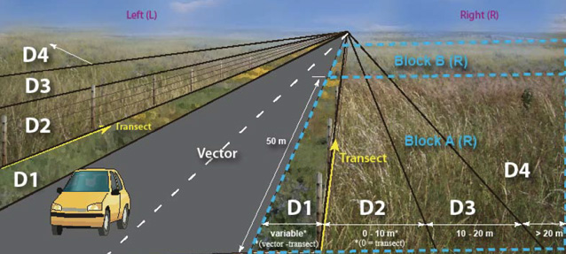
Highest-risk vectors (e.g., roads, trails, rivers) are sampled in parallel 50-m blocks (see figure below). Within each block, a field-crew member walks a transect parallel to the vector. This transect is inset from the edge of the vector and, when possible, located along the interior edge of a mow strip.
When an exotic plant species is found, its distance from the vector provides an indication of whether it has a tendency to invade interior habitats or remain localized near the source of the invasion. The greatest variety and density of exotic plants tend to be found closest to vectors, decreasing as the distance from the vector increases. Observations of a given species are recorded in each of four parallel distance classes (D1–D4) from the vector (see figure below).
Density classes are used to describe exotic species occurrence within a block in one of four ways: less than five plants; scattered throughout the block in a patchy or clumped manner; scattered throughout in an even distribution; or forming a matrix. This distribution corresponds to an initial introduction, establishment, spread, and complete invasion of the habitat, and also provides a baseline to see future changes to exotic plant populations.

Systematic monitoring of interior sites as part of grassland/riparian monitoring
Interior habitats away from high-risk vectors are monitored as part of other, concurrent vegetation monitoring (see network-specific vegetation monitoring protocols for details).
Supplementary monitoring of additional vectors using same field methods as Tier 1
Some parks provide supplementary monitoring of additional high-risk vectors using park staff, volunteers, or citizen science groups. These groups follow the same general protocol described above, but may be more opportunistic in their implementation.
Opportunistic encounters using Science of the American Southwest training products
Parks can use identification and training aids developed to help with opportunistic detection of high-risk species by park personnel, visitors, volunteers, or other groups.
Protocol Status
The initial protocol and standard operating procedures for the Southern Plains Network were developed and field-tested in 2008 and 2009. The protocol was finalized in September 2016 and includes the Chihuahuan and Sonoran Desert networks and their parks. The protocol and associated standard operating procedures are available through the National Park Service Data Store.
Project Contact
Tomye Folts-Zettner, Southern Plains Network
tomye_folts@nps.gov, (512) 925-2406
Originally prepared by Rob Bennetts, Southern Plains Network Inventory and Monitoring Program, 2010. Updated in 2016.
Tags
- amistad national recreation area
- bent's old fort national historic site
- big bend national park
- capulin volcano national monument
- carlsbad caverns national park
- chickasaw national recreation area
- fort davis national historic site
- fort larned national historic site
- fort union national monument
- guadalupe mountains national park
- lake meredith national recreation area
- lyndon b johnson national historical park
- pecos national historical park
- sand creek massacre national historic site
- swscience
- american southwest
- southern plains
- chihuahuan desert
- sopn
- chdn
- plants
- invasive
- exotic
- monitoring
- project
Last updated: August 8, 2017
