Photo by Kirk Stueve
Change is a recurring theme for scientists monitoring and studying Alaska’s expansive landscapes. Warmer temperatures throughout Interior Alaska over the last several decades—average annual temperature increase of 2o to 4o C (4o to 7o F)—have resulted in increased glacial melt, permafrost degradation, and the expansion of woody vegetation. If this warming trend continues, it will change Alaska’s ecosystems and drastically alter the physical appearance of Denali’s landscapes for decades.

Alpine treeline and climate change
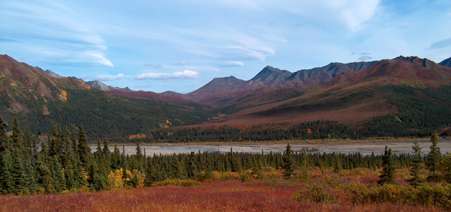
Alpine treeline is the transitional ecological zone between spruce forests at lower elevations and alpine tundra at higher elevations. Because cold temperatures limit tree establishment at high elevations, the alpine treeline zone is hypothesized to be especially sensitive to climatic warming. Treeline in Denali is found at an elevation of about 850 m (2790 feet) on cool north-facing slopes (mostly slowgrowing black spruce), and up to about 1100 m (3600 feet) on warm south-facing slopes (mostly white spruce).
Denali’s greatest biodiversity is found in high treeless tundra, so an increase in tree abundance in formerly tundra habitats may decrease plant diversity and indirectly decrease animal diversity. Another expected consequence of tree invasion into tundra is a change in the habits and movements of caribou and grizzlies, two species that rely extensively on tundra. If tundra habitat disappears from the Denali park road corridor, it may change the experience of tourists wanting to see these two species.
Climate change experts and plant ecologists expect treeline to continue advancing upslope in many areas, but the exact patterns of new tree establishment are challenging for scientists to explain and predict because of complex influences from local site conditions and regional climate variability.
Kirk Stueve, then a Ph.D. candidate from Texas A&M University (now with the U.S. Forest Service), and Rachel Isaacs, then a M.S. student also from Texas A&M University (now a Ph.D. candidate at the Pennsylvania State University), selected a treeline site in Denali to (1) document the spatial patterns of observed treeline changes through fieldverified aerial and satellite image analysis and (2) to determine the relative effects of local site conditions on these changes. The site is about 8.5 km (5.3 miles) north of the park road along the East Fork Toklat River, southeast of the Wyoming Hills.

Photo by Rachel Isaacs
Patterns of treeline change
Prior to arriving at Denali, Stueve and Isaacs used Geographic Information Systems to compare imagery of the site from 1953 (aerial photo) and 2005 (IKONOS satellite image). They identified areas that experienced abundant tree establishment between 1953 and 2005 for fieldwork.
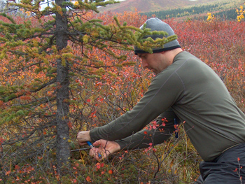
To determine dates of tree establishment and verify changes in the imagery, they extracted increment cores from 40 trees and cross sections from 10 saplings (i.e. to count yearly tree growth rings).
The primary changes observed were (1) infilling of spruce near established trees and (2) patchy upslope advancement of spruce into the alpine tundra. In some cases, newly established trees “advanced” over 150 meters (490 feet) upslope into tundra (compare red arrows).
The field study confirmed that the majority of these trees became established in a few discrete time periods after 1953, but some also became established prior to that year and were not discernible on the 1953 photo. These changes are consistent with other findings elsewhere in Denali over the last 30 years.

The influence of local site conditions
Theoretically, treeline should advance upslope uniformly in the presence of warmer temperatures, but the cumulative influence of local site conditions—both physical (abiotic) and biological (biotic) may prevent this from occurring in a linear fashion—or possibly even hinder tree growth.
Stueve and Isaacs used a digital elevation model, (digital representation of the terrain) and data for prevailing winds, to map local site conditions in relation to the patterns of tree establishment observed between 1953 and 2005 (e.g., see map of summer sun exposure above). They used statistical techniques to determine which site conditions exerted the most control over patterns of tree establishment.
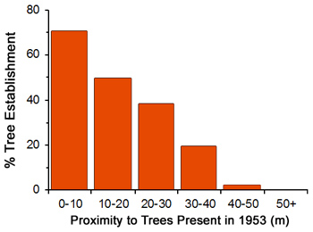
Although the abiotic factors of elevation, winter sun exposure, proximity to streams, slope angle, snowpack, moisture availability, and summer sun exposure were influential (descending order of importance), proximity to existing trees (biotic factor) was the most important variable affecting patterns of tree establishment. Because treeline in this part of Denali is relatively undisturbed, these results challenge the ecological assumption that the vegetation (trees) near treeline is in equilibrium or balance with its abiotic environment.
These findings could mean that: (1) treeline reacts too slowly to climate change and is never in equilibrium with the physical environment, (2) climatic warming in Interior Alaska over the last several decades has been so pronounced that tree establishment lags behind newly suitable conditions near the current treeline, or (3) existing trees modify their surroundings, making conditions in the adjacent tundra suitable for tree seedlings, and upslope advance and/or lateral infilling continues until such time as a major disturbance (e.g. fire or severe climatic cooling event) sets treeline back to a lower elevation.
Regardless of which explanation is true, treeline will likely keep advancing upslope and experience infilling, even if warming trends are tempered in Interior Alaska. However, depending on the balance of moisture (increased evapotranspiration from plants) and temperature at localized sites, some areas could convert to grassland.
Management implications
Changes in Denali’s landscape will likely continue to occur and be most conspicuous at treeline. The approach of analyzing aerial photography and satellite imagery is efficient at capturing change at a broad spatial scale. Not only is it a useful tool in monitoring and explaining changes that have occurred, it may be key to predicting future change and to considering if, or how, such change could be mitigated.
Acknowledgments
This research was partially funded through a Discover Denali Research Fellowship from the Denali Education Center through the Murie Science and Learning Center to K. Stueve.
Last updated: July 28, 2016
