Alaska is—and has been for millions of years—one of the most geologically active regions of North America.

NPS Photo
Modern Alaska began to form hundreds of million years ago as the precursor to the Pacific tectonic plate slowly moved northward. It brought with it fragments of the earth’s crust that fastened onto the edge of the North American plate as the Pacific plate was subducted (thrust under it); these newly-fastened fragments are called accreted terranes.
Alaska resulted from an assemblage of these crustal pieces from the Pacific and other plates. As the Pacific plate continued to subduct under this amalgamation of terranes, immense forces wrinkled and rumpled these terranes northward, causing the buckling and uplift of rocks that would eventually become the Alaska Range.
Studying Faults and Mountain Building
Today, the Pacific plate continues to move. As the plate moves, deformation and uplift of the Alaska Range continue as well. Deformation occurs most easily along the major fault systems that are the boundaries between terranes. Many major faults occur in and near Denali National Park and Preserve—and in the entire Alaska Range—because many terranes have boundaries in this region. Two of the largest faults in the Alaska Range are the Denali and Hines Creek faults. Geologists interested in how the mountains of the Alaska Range (and other mountain belts) develop can study rocks along these fault systems.
The Denali and Hines Creek Faults
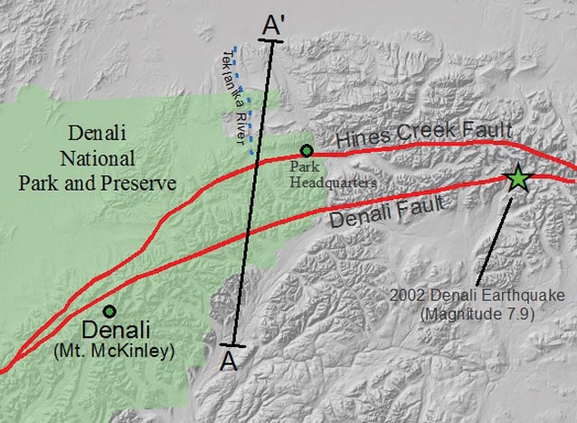
The Denali fault extends for over 3,000 km (1,900 miles) through the Alaska Range and into the Yukon Territory of Canada. A magnitude 7.9 earthquake occurred on the Denali fault in 2002 (see map), less than 100 km (62 miles) from the park.

Another major fault important to the development of the landscape in Denali is the Hines Creek fault. Just west of Park Headquarters, the fault is exposed at Hines Creek (south of the park road) where it was first described and for which it was named.
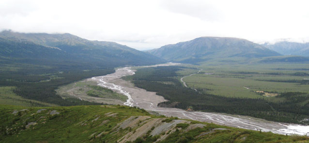
The park road follows the surface trace of this fault from Park Headquarters to the Teklanika River. It is especially clear how this fault has shaped the landscape near Primrose Ridge and Mt. Wright—along the fault, the high hills north of the road have been thrust up and over the relatively low topography to the south, which the park road follows.
To develop a model of how mountain building in the Alaska Range works, and to better understand the tectonics of the region, Dr. Ken Ridgway, a professor at Purdue University, and his graduate student Patrick Brennan, used a combination of geologic mapping and seismic imaging.
Geologic Mapping and Seismic Imaging
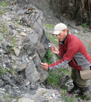
In 2008, Brennan spent three weeks in Denali between the Toklat River and Hines Creek. He mapped sedimentary and metamorphic rocks to determine the location of the Hines Creek fault and to understand the deformation along it.

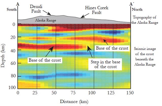
In addition to geologic mapping, the researchers investigated subsurface properties of the Alaska Range by using seismology. When seismic waves pass from one type of rock to another, the wave velocity changes. These changes can be identified at seismic stations. Once the change in seismic velocity has been identified, scientists can calculate the depth at which the change occurs. Using these data, images can be created to interpret the properties of the Earth’s crust deep beneath the mountain belt.
To generate a composite picture of what the crust is like under the Alaska Range (a cross-section view), Ridgway and Brennan assembled subsurface images of the crust from seismic observation points along a transect through the Range. They compared these images about the internal structure of the crust with the observations made at the surface about rock movements and locations of faults to develop a comprehensive model for the development of the Alaska Range.
Results of Geologic Mapping
Ridgway and Brennan found that the rocks at the surface have moved both vertically (thrust faulting) and horizontally (right-lateral strike-slip faulting). These displacements range in distance from a few centimeters (inches) to several meters (several feet).

Results of Seismic Imaging
One of the exciting discoveries from the images of the crust beneath the Alaska Range is the observation of a major “step” or change in depth of the base of the Earth’s crust along the north side of the Alaska Range (see change in depth of red-orange bands in the diagram below left). The crust is ~35 km (22 miles) deep beneath the Alaska Range, but shallows to only ~25 km (16 miles) over a short distance creating a nearly vertical step of about 10 km (6 miles). The location of the step in the crust occurs very close to the mapped surface location of the Hines Creek fault and the old boundary between two pieces of tectonic plates that collided nearly 100 million years ago. Thus, the preexisting weakness of the crust at the boundary across which the step formed has enabled preferential deformation of rocks in this region. Much of this deformation has likely occurred along the Hines Creek fault. The result of this deformation is some of the high topography located along the northern side of the park road in Denali.
Integrated Story
From this research, it appears that the location of the Alaska Range was predetermined by the tectonic events that began millions of years ago. Thus, although the bold, glacier-clad peaks that form the backbone of the Alaska Range within and beyond Denali National Park and Preserve give an impression of strong, rigid rocks, these peaks formed along the relatively weak boundary between terranes. The weak zone between terranes has allowed continued deformation and uplift of rocks at the Denali, Hines Creek, and other faults. The collective result of this deformation and uplift is the high peaks of the Alaska Range and the other spectacular landscapes of Denali. As these tectonic forces continue, the landscapes of the Alaska Range and Denali will continue to change in response.
Last updated: April 22, 2016
