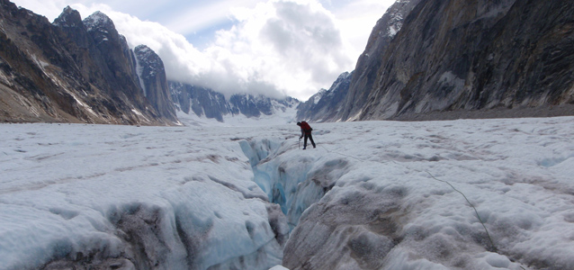
Photo by Joe Bickley
Sheer limestone cliffs and granite spires surrounding more than a dozen small mountain glaciers comprise the Kichatna Mountains tucked away in the remote southwestern corner of Denali National Park and Preserve. Except for a few hardy ice climbers, most park visitors do not travel to the Kichatna Mountains, yet the results of climate change are visible there as glaciers melt and recede. The Kichatna glaciers, being relatively small, are particularly vulnerable to faster rates of melting.
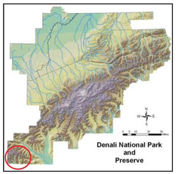
Even though the Kichatna Mountains are located more than 150 miles (240 km) away from the active volcano Mt. Redoubt, they received signifi cant fallout from the ash plume that drifted north after the Mt. Redoubt eruption in March 2009. Where dark ash settled on glaciers in the Kichatnas and elsewhere, any exposed ash absorbs more heat from the sun and may cause the glaciers to melt at faster rates.
Why study the Kichatna Mountain glaciers?
Because glaciers of the Kichatna Mountains are at risk of melting from climate change, as hastened by ash deposits, independent researcher Joseph Bickley decided to study two glaciers there. He selected the Tatina and Cul-de-sac Glaciers because these two glaciers could be fairly easily accessed from Shellabarger Pass. These glaciers flow north and are fairly flat.
While melting has already taken place, he wanted to capture benchmark photos and Global Positioning System (GPS) location measurements of these glaciers before they melted further.
Remote and rugged research
In August 2010, Joseph Bickley and his assistant, Odin Miller, flew by small bush plane to a small gravel airstrip located just outside the park. From there, they trekked 17 miles (27 km) over two days to the vicinity of the glaciers, and camped for 10 days in small tents in Shellabarger Pass just below the glaciers.
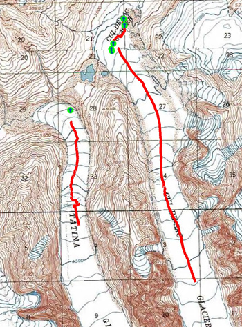
Applying glacier mountaineering skills, Bickley and Miller donned helmets and roped together to travel up each glacier (see red lines on large map) to the line of permanent snow cover where glacier travel becomes more dangerous. Along the way, they took GPS measurements. By combining GPS measurements with data on the underlying bedrock topography, Bickley could estimate the volume of glacial ice. Taken over time, such GPS measurements help estimate a glacier’s melting rate.
The researchers also wanted to map the terminus (end) of each glacier by following the end of the ice as closely as possible, taking frequent GPS locations. While no known historic photos of the two glaciers exist, the two glaciers are shown on the USGS topographic map created in 1958 (see map at right). Bickley wanted to note changes over 52 years by comparing the outline of the glaciers in about 1958 (black dashed line on the map) and in 2010 (from GPS locations recorded on site).
The field team established photo points for each glacier, taking photos at precisely-known (GPS) locations. In future years, these locations can be revisited for repeat photography. A sequence of photos will allow researchers and park visitors to see how the landscape and vegetation are changing as the glaciers melt.
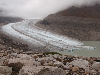
Photo by Joe Bickley
Results of the glacier survey
Bickley recorded a centerline GPS track on the Tatina Glacier (red line) about 2 miles (3 km) long, and one on the Cul-de-sac Glacier about 4 miles (6.5 km) long.
Bickley only took one waypoint at the Tatina Glacier terminus (see green dot on map above) because the glacial lake made access impossible. However, he took both a GPS track (red line) and fi ve GPS waypoints (green dots) to define the Cul-de-sac Glacier terminus.
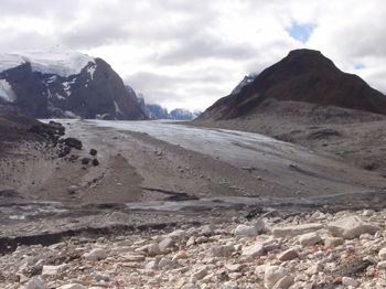
Photo by Joe Buckley
Dramatic signs of melting glaciers
Two photo points were established for each glacier. Baseline photographs taken of the glaciers (see one at right) in 2010 show exposed gravelly soils where the glaciers used to hug the sidewalls of adjacent mountains in previous decades or centuries. The recession of the glaciers from the mountain slopes are the most dramatic changes. But changes in the terminus of each glacier are substantial as well. The current western edge of the Cul-de-sac Glacier is now approximately 1/5 mile (0.3 km) from where it used to touch the mountain wall as recently as 1958, and the terminus face itself has receded approximately ½ mile (0.8 km) from its 1958 location.
The melting of glaciers results in newly-exposed soils that are already beginning to revegetate with various sub-arctic early successional plant species such as dwarf fireweed, horsetail and netleaf willow.
What’s next?
Future photographs and GPS surveys of the two glaciers will provide both visual documentation of the glaciers’ melting over time and an estimate of how fast this is occurring (a rate of melting or receding).
Last updated: July 28, 2016
