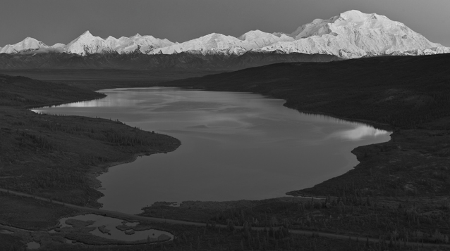
NPS photo
Limnology is the scientific study of inland waters, most commonly lakes. To understand ecosystem processes at landscape scales, limnologists have become increasingly focused on the distribution and function of lakes across large regions.
More than 4,000 lakes are scattered across the landscape of Denali National Park and Preserve, serving important functions to wildlife and subsistence ways of life (e.g., fishing). These lakes are variable in origin and range in size from small ponds to very large lakes. The majority of lakes in the park are very small and cover only a small portion of the landscape, yet the few large lakes increase the total lake area greatly.
Two coordinated scientific studies are gathering more information about Denali’s many small lakes and ponds, as well as a few of the largest lakes. For the large lake study, researchers from the U.S. Geological Survey, Alaska Science Center, along with Denali staff, selected Wonder Lake, Lake Chilchukabena, and Lake Minchumina (its watershed is partially within the park, although the lake is outside the park). The goal of this research is to develop a baseline of water quality for these three lakes, and to identify how the physical properties of these lakes are linked to watershed processes and climate.
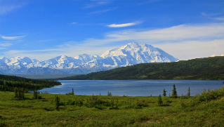
Diane Kirkendall
Wonder Lake
The seventh largest lake in the park, Wonder Lake was formed by a series of glacial advances and retreats of the McKinley Glacier flowing off Mount McKinley. Knowledge of its formation may be reflected in the Athabascan name Deenaalee Bené, which means lake of the tall one. Wonder Lake likely holds the most water of Denali’s lakes, as it is the deepest at more than 200 feet (70 meters). Chemical data indicate its water has a relatively long “residence time” (the average time that water entering the lake stays in the lake).
Lake Chilchukabena
Chèlkoghee Bené, meaning “big, stout lake” in Athabascan, has the largest surface area in the park, but is very shallow (less than 10 feet (3 meters)). The origin and source-waters of this lake are still uncertain, but likely relate to its position between the hills where the Muddy and McKinley Rivers and Birch Creek converge to form the Kantishna River. In summer, this lake supports rich blooms of algae, plankton, aquatic plants, and many ducks and swans.
Lake Minchumina
Located just outside the park, Minchumina (or Menche Mená meaning “big-lake lake”) has a larger surface area than Chilchukabena. Climate information is available for Lake Minchumina from a local airport weather station. In recent years, air temperatures in many parts of the subarctic show increasing trends. However, at Minchumina, spring temperatures have been below average for much of the last decade. A 1979 study, concerning the effect of Lake Minchumina on local climate, documented that the Minchumina area had higher summer temperatures and fewer frost-free days compared to nearby Alaska stations without large lakes. Knowledge of local climate trends from longterm residents at Lake Minchumina helps greatly in interpreting the limnology studies underway.
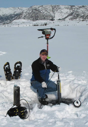
USGS photo
Lakes and climate change
How climate change affects lakes is of current interest to limnologists, other scientists, and land managers. In Denali, researchers hope to understand the physical behavior of these big lakes in relation to climate. In particular, how does a changing climate affect (1) the timing of ice-out and ice-on, (2) the temperature and mixing of lake waters, and (3) the seasonal and long-term changes in surface area and volume?
Ice cover and lake temperatures
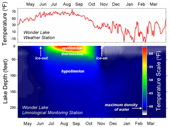
While ice-covered, lake water is the same temperature from top to bottom. Once lakes are ice-free, surface heating begins. Lakes may develop zones of rapid temperature change (i.e., a thermocline—see green band in figure at bottom of page) which isolates cold waters at depth from warm surface waters. A lake is stratified when it has layers of water of different temperatures.
Especially in the subarctic where summers are short, the timing of limnological events (ice-out, stratification, and ice-on), and how it varies from year to year and from lake to lake, are important components of landscape limnology. To monitor lake temperature and to better understand lake phenology (timing of events), USGS researchers Tim Brabets, Dan Long, and Chris Arp installed sensors at multiple depths in each of the three big lakes in early spring 2007. The sensors remain suspended to record temperature at different depths for a year or more and are then removed. “Ice-out” occurs when the surface temperature warms above freezing.
NPS photo
When the sensors were installed, ice thickness was recorded as 29 in (73 cm) at Wonder Lake, 35 in (90 cm) at Lake Minchumina, and 43 in (110 cm) at Lake Chilchukabena. Modeled maximum ice thickness for all lakes occurred about April 5. Compared to predicted ice thickness from models, Wonder Lake ice was thicker, and Chilchukabena ice was thinner, than predicted— likely due to differing snow conditions.
Based on sensor readings, ice-out in 2007 occurred at both Chilchukabena and Minchumina on May 20, one week earlier than at Wonder Lake (May 27). USGS researcher Ben Jones confirmed these dates using satellite imagery on all lakes, and local observers confirmed the dates at Minchumina and Wonder Lake.
During the summer of 2007, Wonder Lake began to develop temperature differences with depth (stratification) soon after ice-out, with a strong thermocline developing by late June (see figure at bottom of page). Water temperatures remained the same throughout the water column at Lakes Minchumina and Chilchukabena during most of the summer, likely due to shallower depths and mixing of water by wind and river currents.
Are lakes changing in surface area?
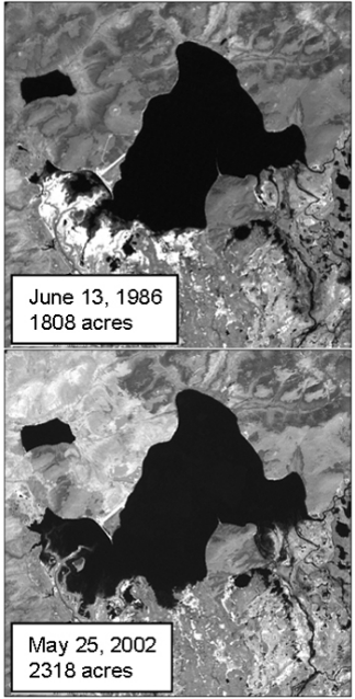
Satellite images can be used to measure lake surface area and analyze change over time in relationship to climate and permafrost dynamics. Researchers compared Landsat images for late spring, cloud-free days in 1986 and 2002 for the three lakes. There was a 28 percent increase in lake surface area for Minchumina (see photos at right), while Lake Chilchukabena and Wonder Lake were stable in surface area. Most likely, the different response of these lakes over time relates to lake basin shape. Also, Lake Minchumina is fed directly by the Foraker River and several creeks, so changes in annual runoff and spring flooding may play an important role in this lake’s size and “water budget.” Mapped surface area from the 1950’s shows Lake Minchumina once had a larger surface area than it does at present.
Lakes may serve as sensitive indicators of how the climate is changing. For example, lakes may expand during wet summers and shrink during dry summers with high evaporation. In Denali, lake water budgets may respond to the balance of precipitation and evaporation in summer, but also to other factors such as variation in snowpack and river discharge by melting glaciers, and excessive sedimentation.
USGS photo
Monitoring lake changes
Researchers will continue the limnological studies in Denali to better understand how and why lakes respond to climate change. These investigations of lake phenology and lake water budgets in relation to climate change will help park managers predict how wildlife and subsistence users may be affected by changes in lakes across the landscape.
Last updated: July 28, 2016
