NPS photo
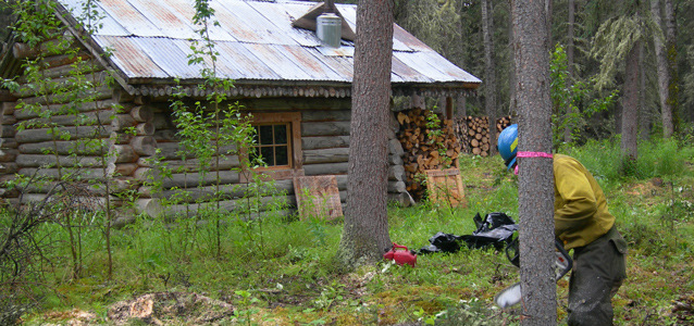
At 12:26 pm on June 17, 2005, the Roosevelt Cabin was smack on the path of the McKinley Fire, a mere eight miles away. Under the right fuel and wind conditions, such a distance is an easy afternoon’s run for a fire. The job for the small crew who landed by helicopter was clear—remove or reduce flammable materials from the area surrounding the cabin to prevent any approaching flames from jumping to the structure. Some trees would be cut, brush and grasses trimmed, a sprinkler system put in place with portable pumps, and the crew would leave safely.
The fire veered in a different direction and got no closer. But wildland fire does happen at Denali. Rather than risk placing fire crews near an oncoming fire to make these last-minute preparations, fire staff proactively plan and prepare infrastructures throughout the park in advance of the eventual wildland fire. “Firewise” is the process of creating defensible space around structures to provide a safer environment—for subsistence cabin users, visitors, park staff, and firefighters—in the case of wildland fire. Use of Firewise techniques lessens wildland fire risk to remote structures such as the Roosevelt Cabin or to buildings near park headquarters or along the park road.

NPS photo
Why is the risk of fire high at Denali?
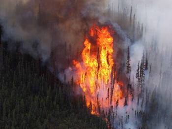
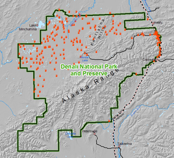
Periodic large- and small-scale wildland fires have burned across the Denali landscape for thousands of years. Where the landscape receives more moisture south of the Alaska Range, fires occur infrequently and are usually fairly small in the forests of aspen, cottonwood, and birch. It is in Denali’s northwest taiga and tundra, where black spruce is abundant and where precipitation is limited, that fire is a dominant process. Wildland fire is a natural and significant force that shapes the boreal forest and tundra ecosystems. However, in Denali as elsewhere, where cabins, homes, offices, and visitor centers have been built within these fire-dependent ecosystems, the structures are vulnerable to wildland fire, sometimes burning more readily than the forest or tundra nearby.

Photo courtesy of Harpers Ferry Center
Fire behavior and planning for defensible space
In general, wildland fires behave differently depending on the topography, weather (temperature, wind, and relative humidity), and vegetation (fuels). Fires burning up a slope spread several times faster than on level terrain. Wind, lower relative humidity, and higher temperatures all increase fire activity. Virtually all vegetation types in Denali can burn, but black spruce is especially fire-prone.
Aspen, birch, and cottonwood are less likely to burn except during periods of exceptionally hot, dry, and windy weather. During dry periods, ground vegetation such as Labrador tea or feather moss can carry fire into the limbs of spruce, promoting the ignition of individual or groups of trees. Ember showers from these burning spruce tops can easily create spot fires that spread wildland fire further.
Fire managers developed Firewise techniques based on their knowledge of fire behavior. Structures that have been Firewised have a greater chance of withstanding an extreme fire than those that have not. The techniques include: (1) thin trees to reduce the likelihood that fires will spread from tree to tree, (2) remove lower branches so they won’t serve as “ladders” for fires to climb into tree canopies, (3) keep brush and grasses trimmed and relocate other fuels (e.g., woodpiles, gas tanks) to prevent fire spread, and (4) assess the fuels downslope of a structure and reduce them adequately to prevent fire spread during an uphill fire surge.

Zones of defensible space
Denali fire staff creates defensible space around any structure according to the three zones of Firewise, as adapted for Alaska, regardless of whether the structure is a backcountry cabin or a building at park headquarters.
In Zone 1 (within a 30-foot radius of the structure), fire staff removes most vegetation, but does not create a “clear cut”. The staff carefully tags spruce trees and any dead or diseased birch or aspen for removal; trims brush and grasses; and moves other fuel sources (wood piles, fuel tanks) away from the structure. In Zone 2 (30-to 60-foot radius circle), fire staff cuts some spruce trees but retains others for wildlife habitat or visual screening. Staff trims lower limbs of the remaining spruce, varying the height of trimming to create a more natural appearance. In Zone 3, (60- to 90-foot radius), staff cuts enough spruce to create a 20-foot space between tree crowns. Aspen and birch are left in all zones unless they are a fire hazard (i.e. dead or diseased).
The defensible space created in these three concentric zones (see summary at bottom of page) allows radiant heat from a wildland fire to dissipate as it enters the outer zone, prevents the spread of fire to the inner zones, and prevents building ignition.
Firewise—universal application
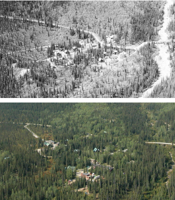
The frontcountry of Denali (entrance area, park headquarters, Toklat road camp) includes many structures that were built within spruce forest. Vegetation may provide a sense of seclusion, but fuel buildups significantly increase the time, effort, and resources needed to safely protect life and structures during a fire.
Following Denali’s Fire Management Plan (2004), Denali fire staff have used the zone approach to Firewise buildings and facilities in the park headquarters area in 2004 and at Toklat in 2005. The same techniques and zones are being applied to ranger patrol and subsistence cabins scattered in cabins in the backcountry. Many of these flammable structures lie in the fire-prone forest in the northwestern part of the park. Each year fire staff creates defensible space around two to five cabins based on a priority list. If a wildland fire ignites near an untreated cabin, fire staff changes the work priorities, and moves immediately to prepare the defensible space for the at-risk cabin well in advance of the fire. Periodic vegetation management will continue to maintain these defensible spaces.
Anyone can apply these same Firewise techniques— by zone—around any valued structures. View some illustrations of Firewise techniques for homes.
Firewise Zones of Defensible Space to Reduce Risk of Wildland Fire to Structures
Zone 1 (0- to 30-foot radius)
•Reduce density of vegetation
•Remove dead vegetation
•Trim remaining vegetation
•Store fuels away from structure
Zone 2 (30- to 60-foot radius)
•Remove some trees to create spacing between crowns
•Remove low branches
•Trim brush, grasses
Zone 3 (60- to 90-foot radius)
•Remove some trees to create spacing between crowns
Last updated: July 28, 2016
