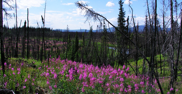
Wildland fire is one of the most influential natural processes shaping the boreal ecosystems of Denali National Park and Preserve. Wildfires are not frequently visible from the park road, yet nearly one-seventh the area of the park—more than 330,000 ha (830,000 acres)—has burned in and near the park since the 1950s.
Fire-adapted ecosystems in Denali include black and white spruce forests, mixed aspen-birch-spruce forests, and tussock-shrub tundra. Fire maintains this landscape, which, when viewed from above, often resembles a patchwork of burned and unburned areas. Large natural fires occur almost yearly in the fire-prone lowland black spruce forests of the Minchumina Basin—in Denali’s northwest corner.
In Denali and elsewhere, fires can change vegetation structure and composition, wildlife habitat, permafrost dynamics, nutrient cycling, and biodiversity. Burn severity strongly influences vegetation patterns and succession after fire—a highseverity burn may kill trees or shrubs at a site, while a low-severity burn may just singe or top-kill plants. In addition, the natural fire regime (i.e., fire frequency, fire extent, and severity) responds to local and global climate changes. Understanding fire and its role in the landscape helps park managers make decisions and institute practices that help maintain natural fire and balance the risks and benefits of fire.

Studying Fire and Vegetation Response
To guide fire and land management planning in Alaska national parks, the regional Fire Ecology program conducts studies in fire-adapted ecosystems. Some questions being addressed by the Fire Ecology program are: (1) How does burn severity influence post-fire vegetation succession? (2) How can postfire vegetation data be used to update landcover and vegetation maps? and (3) How does fire affect the vegetation that moose prefer to browse?
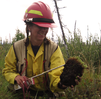
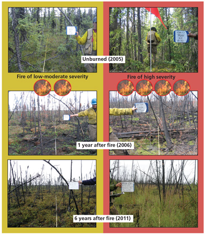
To address these questions in Denali, fire ecologists and Denali fire staff established 98 study plots in 2005 and 2007 in the fire-prone northwestern part of Denali. The plots were established in areas that were either unburned or burned (1-9 years or 10-20 years post-fire). By chance, in 2005, the 114,000-acre Highpower Fire re-burned 10 of the 2005 plots. These plots were measured again in 2006 and 2011.
At the plots, the fire ecologists took photos, recorded plant cover (including mosses and lichens), and counted trees by species and size (to document trees that survived and new seedlings). They also measured depth to permafrost and recorded burn severity and the density of shrubs and trees known to be favored by moose.

Results: Impacts of Burn Severity on Vegetation
In general, shrubs re-established to the greatest extent after low-to-moderate severity burns. In black spruce forests with low-to-moderate burn severity, low shrubs such as Labrador tea, low-bush cranberry, blueberry, cloudberry, and dwarf birch (in order of abundance) re-sprouted readily after fires.
In contrast, fewer shrubs re-established in plots where high severity burns occurred. These areas were more likely to be dominated by grasses and other herbaceous plants within the first few years after the fire. Severe burns often consume more of the forest floor organic layer and may kill more of the shallow, underground root structure of some plants. Plants such as bluejoint grass, horsetails, and fireweed were more common in severely burned areas in the first decade after the fire.
Regardless of burn severity, spruce trees do not usually survive if impacted by fire. However, if an area was a spruce forest prior to a fire, then spruce usually dominate again 50-100 years post fire. Black spruce forests, in particular, are likely to dominate the landscape because abundant black spruce seeds are released from semi-serotinous cones (open in response to the heat from the fire).

Results: Landcover Mapping
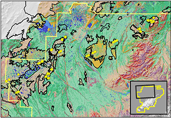
Fire prone areas on landcover maps become outdated because vegetation changes in recently burned areas are no longer reflected in the maps. Fire ecologists used data from the studies to update over 243,000 ha (600,000 acres) of Denali’s landcover map.
To predict changes in vegetation type in order to update the map, a vegetation change model was developed based on pre-fire vegetation type, burn severity, and time since fire. The new map shows less spruce (green colors) where recent fires have burned (black outlines). The improved map will provide a more accurate representation of vegetation and fuels for fire behavior modeling tools.
Results: Effects of Fire on Moose Browse
Willows, a plant that moose often browse, were most abundant in study plots that were 10-20 years postfire. Likewise, the greatest amount of browsing by moose was recorded in these same areas. However, only one-quarter of all the plots sampled had willows. Thus, while not all burned plots had willows for moose, the plots that had the most willows were ones that were in areas 10-20 years post-fire.
Last updated: April 22, 2016
