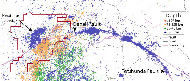
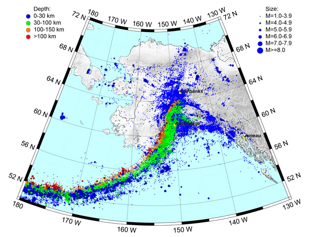
Figure by Alaska Earthquake Center
With more than 20,000 earthquakes reported annually, Alaska is by far the most seismically active state. Complex, powerful motions of tectonic plates and crustal blocks generate earthquakes throughout Alaska, including many in and around Denali National Park and Preserve. Alaska not only experiences the most earthquakes in the United States, but also the strongest. The Good Friday Earthquake—a 1964 magnitude 9.2 event located in Prince William Sound—remains the largest earthquake ever recorded in the U.S. and the second largest earthquake ever recorded worldwide.
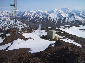
Photo courtesy of Alaska Earthquake Center
Alaska Earthquake Center
To monitor seismic activity, staff from the Alaska Earthquake Center install and operate seismic stations across the state. Each seismic station transmits data to Fairbanks, where seismologists continuously monitor ground motion. Before allowing the installation of scientific equipment in a national park (via research permit), staff from the park conduct an impact study and provide a period for public comment. Alaska Earthquake Center has four seismic stations in Denali: (from west to east, see map) Castle Rocks (CAST), Kantishna Hills (KTH) on Wickersham Dome, Thoroughfare Mountain (TRF), and McKinley (MCK) near the park entrance.
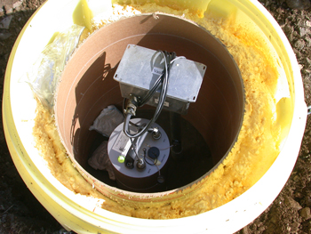
Photo courtesy of Alaska Earthquake Center
Each of these seismic stations is instrumented with a broadband seismometer to detect ground motion, a data digitizer to record displacement, a radio to transmit the data, and solar panels to help power the equipment. In addition, CAST, KTH, and MCK are instrumented with accelerometers to measure ground acceleration. To send these continuous ground motion data to a central location for analysis, Alaska Earthquake Center also operates radio repeaters within the park at Double Mountain, Mount Healy, and the Murie Science and Learning Center.
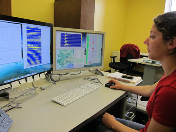
Photo courtesy of Alaska Earthquake Center
Was That an Earthquake?
Real time ground motion data from ~400 seismic stations across the state are used to identify and characterize each earthquake in Alaska. Automatic locations are available within five minutes on the Alaska Earthquake Center’s webpage. If the automatic location algorithms indicate a large earthquake, the seismologist on duty responds immediately (seismologists are on call 24/7) and issues an information release—in part to help emergency management personnel respond to significant events. Every event is briefly reviewed by the on-duty seismologist, and carefully relocated by an analyst. Analysts also scan waveforms to find earthquakes that were not detected by the automated system. Alaska Earthquake Center analysts locate between 20,000 and 30,000 earthquakes in Alaska each year.
Where do Earthquakes Occur in the Park?
Earthquakes shake the ground daily, but most are minor local events. Seismicity in interior Alaska north of the Denali fault is dominated by shallow events (see blue dots on map above). Note how the blue dots scattered at the top of the map track roughly northeast-trending parallel lines. These lines are shear zones where smaller crustal blocks are shifting between major faults. Movement at shear zones have generated up to magnitude (M) 7.3 earthquakes. The Kantishna cluster is a group of small, shallow earthquakes—not far from Wonder Lake—at the southwestern end of a shear zone. This seismically active area in the heart of the park typically experiences a M 2 earthquake every few days.
Deep earthquakes occur under the ground in the southern and eastern portions of the park (see red-orange and orange dots on the map above). These quakes are associated with the northern extension of the subduction edge of the Pacific plate and its dive beneath the North American crust. The Pacific plate is moving northwest relative to Alaska, causing many earthquakes along the interface. The pattern of shallow, intermediate, and deep events in south-central Alaska highlights the shallow angle of the subduction. In the Aleutian Islands, where the subduction angle is much steeper, the shallow-to-deep earthquake pattern is more compact.
Earthquakes Outside the Park
The interaction of the Pacific and North American plates across southern Alaska creates a variety of sources for seismic activity. As crustal blocks slide horizontally past one another, strike slip faults occur; when blocks are pushed together, one block is thrust up or down along the fault line.
Great earthquakes (those with M greater than 8.0) typically occur along the Pacific-North American plate boundary far south of the park. The 1964 Good Friday Earthquake is an example.
Major earthquakes (those with a magnitude range of 7.0-7.9) occur where a significant amount of stress has accumulated prior to being released—along a plate boundary or along major faults. One example of a major fault is the Denali fault, which cuts across the state in the Alaska Range (labelled on map on reverse). In 2002, the M 7.9 earthquake ruptured a portion of the Denali fault east of the park to produce a horizontal offset of up to 8.8 m (29 feet). The main shock occurred about 80 km (50 miles) east of the Denali Visitor Center. In the months that followed, roughly 25,000 aftershocks were located on the Denali and Totshunda faults, revealing a surface rupture that was 325 km (200 miles) long.
Is Denali Waiting for the Big One?
The section of the Denali fault cutting across the park has not experienced a major earthquake within the last ~100 years. The more stress that builds up across a fault, the larger the earthquake is when that stress is released. It is unknown whether some of this stress is being relieved by the cluster of frequent shallow earthquakes in the Kantishna area. As the stress mounts along the Denali fault in the park, and as more time elapses without the stress release of a strong earthquake, the probability of a big earthquake in the park continues to rise.
Map Courtesy of Alaska Earthquake Center
Last updated: October 26, 2021
