NPS Photo / Tim Rains
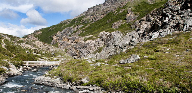
The Savage River day use area is a popular destination for many visitors to Denali National Park. The trails and infrastructure in the area receive significant use, however, the area also displays geomorphic indications of significant downslope motion, frequent trail erosion, and documented damage to the wooden hiking bridge at the far end of the Savage River Loop Trail. In order to aid decision making about future infrastructure and trail maintenance in this area, we developed and implemented a repeat GPS survey of monuments along the trail. With these data we hope to quantify downslope movement, identify the fastest moving areas, and better understand the geologic mechanisms at work.

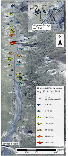
We installed ~50 survey monuments along the Savage River Loop Trail, with slightly higher monument densities in areas with higher likelihoods of rapid downslope movement and/ or importance to trails and infrastructure. Given considerations for Denali’s wilderness, these survey monuments are extremely low visibility depressions of only a few millimeters drilled into strategically located boulders on the hill slope. GPS survey monuments were installed during the mid to late summer of 2013 and were relocated through the use of detailed photo documentation in October, 2014. We utilized a precision GPS unit that can resolve any change of greater than ~3 cm in monument location between repeat surveys.
The annual downslope horizontal motion recorded at many of our survey markers was much higher than anticipated. The average recorded horizontal downslope motion was ~12 cm with about half our sites recording motion of greater than 10 cm and several sites recording ~50 cm of motion. These values are significantly greater than we anticipated assuming that the majority of slope mobility in the area was a result of a geomorphic process called solifluction - where seasonal freeze and thaw in moist soils creates downslope movement. However, these rates would be among the highest rates of solifluction in the world, leading us to suspect that additional motion at depth is involved.
The results of this study were initially intended to inform the Denali National Park trails crew regarding trail building and maintenance decisions. To this end, these data identify areas of rapid downslope motion where trails are likely to be rapidly degraded or moved downslope into the river and eroded entirely, and they may assist in determining the best repair plans for the wooden hiker bridge at the north end of the canyon loop which is being actively deformed and compressed by convergent downslope movement of material at both ends of the bridge. These data may also help to inform the park and the Federal Highway Administration (FHWA) on the construction of a proposed pedestrian bridge just north of the park road. The proposed bridge would span the Savage River near the two parking lots that currently mark the two ends of the Savage Canyon Loop Trail. While survey data from future years and the results of a FHWA well monitoring study in the same location are needed for any engineeringlevel decisions, preliminary data indicate that area around the proposed bridge site is relatively stable.
Last updated: April 28, 2016
