NPS Photo
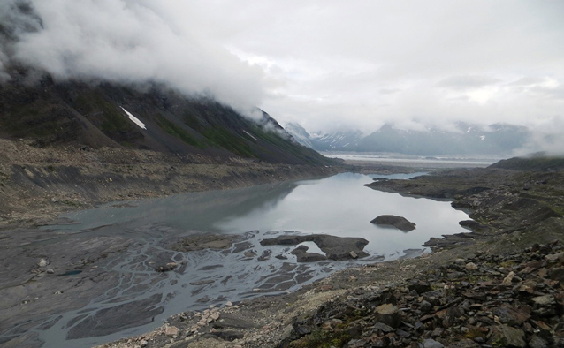
Backside Lake is located on the south side of the Alaska Range immediately adjacent to the lower Ruth Glacier at 2780 feet (see map below). Currently, Backside is the only lake within the park that is being utilized for commercial float plane landings. Commercial landings are authorized there through the authority of Type III Concession Contracts, which authorize the holders to provide “Glacier landing air taxi and/or glacier landing scenic air tours for the public on glaciers within the boundaries of the 1980 south side park and preserve additions”. At the present time, there are four concessioners authorized to provide these services. Private float planes may land on the lake as well. In addition, there is a gravel air strip located approximately one-half mile southeast of the lake. This access coupled with beautiful alpine terrain suitable for hiking and backpacking experiences are a desirable combination not readily available elsewhere within the park. Through air travel, visitors are inserted above timberline to explore glaciers, glacial lakes, alpine meadows, non-technical peaks and generally the grandeur of the Denali high country.
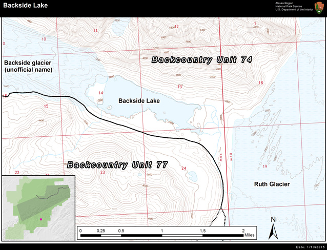
Numerous management overlays exist in the location of Backside Lake. As defined by the Denali National Park and Preserve Final Backcountry Management Plan of 2006 (the Plan), Backside lies within Management Area A, and well as within the Ruth Glacier Special Use Area. The purpose of Management Area A is defined in the Plan to “provide a diversity of opportunities for wilderness recreational activities that are relatively accessible to day-users and to those who have limited wilderness travel skills or equipment.” The Ruth Glacier Special Use Area is defined in the Plan to “provide for high use of transportation services during the season when large numbers of day users are accessing the Ruth Amphitheater. Seasonal, May – September.” In addition the Plan states that “Air taxi landings could occur throughout the park additions and preserve. To be considered an “air taxi” landing, the majority of passengers on the flight must either be dropped off or picked up from a day trip or overnight stay and passengers do not remain with their airplane while on the ground. ‘Scenic air tour landings’ are distinguished by passengers remaining with their airplane while on the ground. Scenic air tour landings will be allowed on glaciers in all areas designated as Management Area A.” The Denali Superintendent has authorized these to take place on the lake as well.
Eight trips by 18 NPS staff from five work divisions made observations at Backside Lake between June 13 and September 12, 2014 on trips that varied from 3 to 10 days. Staff camped close to the lake and did day hikes similar to the base camping guides and clients and were present to make observations for a total of 49 full days out of a possible 86 days of the summer season (57% of total observed).
The primary CUA holder had mixed compliance with 2014 NPS CUA specific activity stipulations. However, they consistently practiced good sanitation, erected and maintained working bear fences around camps, and practiced appropriate hiking dispersion to protect soils and vegetation. CUA holders are stipulated to “have only one hiking group in the area at a time. This limit applies to both Day Hiking and Overnight Hiking groups; a CUA holder who provides both Day Hiking and Overnight Hiking services in the same area must limit the number and coordinate the movement of their groups to adhere to this requirement. A short overlap of groups arriving at or departing the area while waiting for air taxi transportation is allowed.” However, this was violated on 68% of the trips.
Staff observed at least 17 species of wildlife in the vicinity of Backside Lake including nesting/rearing rock ptarmigan and semi-palmated plovers. Bears were observed in the area on 12 days. All observations were of black bears except one sighting of a grizzly bear. Bears were commonly seen on the alpine tundra benches and ridges to the south of Backside Lake. There were three occurrences of bears entering the camps of NPS staff. No damage was done, nor did bears get into human food. However they were relatively unafraid of humans and one black bear pawed at a tent with the human occupants inside.
Estimates of visitor use numbers at and around the lake come from two sources 1) self-reported data from the concession and CUA holders; 2) observations by NPS staff.
NPS Photo
Observations from NPS staff indicate that the vast majority of visitor use is guided. According to the CUA holder reported data they guided 385 people, of which 72% were day visitors and 28% were overnight.
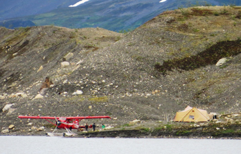
Generally, the amount of people and aircraft use observed by NPS staff seems to concur with that reported by concession and CUA holders, however the goal of NPS observations was not to capture absolute numbers of people, but rather to observe encounters with aircraft and people and their current activity (day hiking, backpacking, base camping at the lake, and briefly landing during a scenic air tour (SAT)). The only discrepancy between the data reported by commercial operations and NPS is regarding SAT landings. The NPS observed 13 SAT landings during observation days, whereas only 2 were reported. The definition for SAT used by field observers assumed that landings with a stopover of less than an hour that did not drop off or pick up people were SATs. However, passengers embarking and disembarking from the plane was not specifically tracked by NPS staff but all of the landings field observers identified as SATs beached on the NW corner of the lakeshore, which is not a convenient drop off location for longer day hikers or overnight users.
Field observers did not focus on capturing numbers of individual people that visited the area, but rather the number of encounters with other groups of people. Encounters with other groups are an important Plan indicator because they affect opportunities for solitude and movement of groups back and forth across the same areas have an effect on informal trail impacts.
The numbers of encounters with other groups were somewhat inflated by the presence of NPS staff since they were another group to be encountered. While removing the NPS group could drop the observed indicator to the level at or below the standard, the data including the NPS is considered valuable because their observations represent what an additional group base camping by the lake may experience. While very few private groups were observed, it is likely that word will spread about this area and it will receive more independent/private visitors in future years. Since NPS observers noted if other groups exclusive of themselves camped within sight of each other it was possible to remove that impact from calculating the indicator, which brought the percent of days exceeding the standard from 41% to 10%.
Encounters with modern equipment were driven primarily by seeing float planes on the lake. A few small landscape modifications such as cairns (many of which marked the gravel airstrip as well as trails), float plane anchor, and evidence of an old campsite were included in the encounters, but CUA holder camps are not included in this number even though these camps had electric bear fences, buckets for food storage, toilet buckets, and tent pad excavations. Counting any of these landscape modifications, but particularly the CUA camps pushes the “No landscape modifications allowed for visitor use” indicator out of compliance.
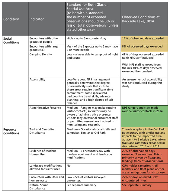
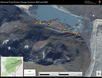
The level of informal trail disturbance appears to be similar to Old Park 1 management area where there are trail impacts around nodes and much larger unimpacted or lightly impacted areas surrounding the nodes. However the level of campsite disturbance is very different than anywhere in the backcountry of OP1 because of the concentration of campsites near to the shore of Backside Lake. Informal trail length expanded by 3.5% between July 2013 and August 2014. Informal campsite impacts increased 927% from 75 m2 impacted to 770 m2.
The Backside Lake site was located in the Ruth Glacier Special Use Area, which is to be managed for a ‘Very High’ level of soundscape impact. Despite these very high thresholds, soundscape conditions created by air traffic are chronically out of standard.
Measuring the rate and overall number of aircraft takeoffs at Backside Lake was the second major purpose behind deploying a sound station in the area. Over the sampling period from 05/15/2014 through 09/11/2014 (a period of 119 days) there were 155 takeoffs counted from Backside Lake. There were 140 landings/takeoffs from K2’s self reported data and NPS contracted flights between 5/15 and 9/11. The higher count as determined from the soundscape station data could be from private aircraft landings/takeoffs and/or errors of interpretation in the soundscape data. In addition K2 had 5 ski plane takeoffs/landings in mid April 2014 for skiiers.
The first take off event of the summer season occurred on 06/15/2014 (which concurs with K2’s data), a month into the soundscape record, which means the effective sampling period is only 88 days. Over this shorter period, 20 days (or 23%) had no takeoffs during the day. The maximum number of takeoffs in a day was 6, occurring on 06/23/14. The median was 1.0 takeoffs per day, while the average was 1.8 takeoffs per day.
Although it is not an official indicator, it is worth considering noise free interval (NFI) at Backside Lake as well. A noise free interval is simply the typical quiet time between successive noise events. As such it is the experiential manifestation of traffic rate. The two are inversely related such that as the number of noise events increases from zero, NFI drops quickly at first and then asymptotically approaches zero. For instance, with a median traffic rate of 50 events per day, the median noise free interval at Backside Lake in 2014 was four minutes. Only 3% of intervals were longer than 4 hours.

Last updated: May 19, 2016
