Last updated: August 22, 2017
Article
Debris Flow Processes on Mount Rainier

Importance
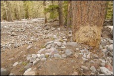
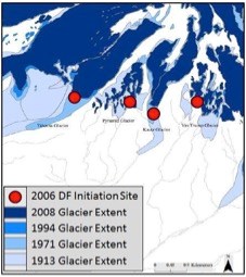
After eruptions and lahars, debris flows represent the greatest hazard originating from volcanoes. In Mount Rainier National Park, recent debris flows and associated floods initiating near glacier termini on large glaciated volcanoes have extensively damaged highways, forests (Figure 1), and National Park infrastructure. A storm in 2006 dropped approximately 18 inches of rain in 36 hours across the Cascade Range and unleashed debris flows from the proglacial areas of six drainages within the park (Figure 2). Infrastructure damage totaled approximately $36 million in Mount Rainier National Park (MORA) alone, with major damage also inflicted on roads adjacent to Mount Hood in Oregon. This event, combined with other similar events in the early 2000s, caused scientists to hypothesize a connection between climate change, concomitant glacier retreat, and debris flows.

Our research aims to shed light on debris flow processes in the park, which in turn will inform debris flow forecasting. First, our research seeks to reconstruct occurrence of debris flows from the present through the Little Ice Age (approximately 1500 – 1850 AD, or 500 to 150 years before present), a period when glacier fluctuations in the park are well-constrained. Past debris flow occurrence relative to known glacier fluctuations can suggest future occurrence of debris flows with respect to projected glacier retreat. Second, we are studying the initiation processes that give rise to debris flows. This project phase will enhance our understanding of where and when debris flows occur. Ultimately our results will increase managers’ ability to forecast debris flows and mitigate damages to park resources.
Status and Trend
Debris Flow Frequency: We are actively studying debris flow occurrence in the Kautz Creek drainage. Preliminary data suggest a lower frequency of debris flows relative to present during the Little Ice Age (glaciers in advanced position). We are currently evaluating the completeness of this debris flow chronology and will report final results within the next year.
Discussion
Debris Flow and Glacier Retreat: We hypothesize that glacial retreat exposes sediment that can then be mobilized as debris flows. Our debris flow frequency results (preliminary) from Kautz Creek support this hypothesis. However, we are actively seeking to understand if increased debris flow frequency associated with less extensive glaciers is a short-term response to glacier retreat, or if enhanced debris flow occurrence is permanent and will persist until glaciers re-advance.
Debris Flow Initiation: Debris Flows typically mobilize when a landslide liquefies and flows down channels. However, our analysis of recent initiation zones suggest that Mount Rainier debris flows are atypical in that they do not mobilize from one single landslide. Instead, gully networks that have produced debris flows have evidence of progressive addition of sediment to stream flow until the flow is a debris flow. This simple observation is allowing us to analyze the gully geometry necessary for debris flow initiation. We can now map gullies with these characteristics across the park to identify areas of elevated debris flow hazards.
