Last updated: July 27, 2020
Article
Combining the Old and the New to Monitor Harbor Seals

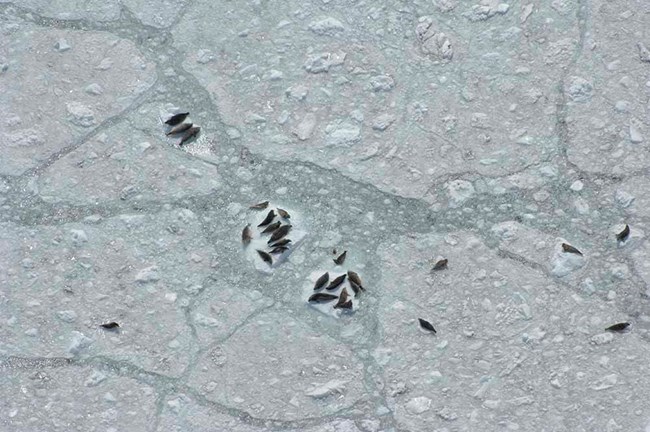
Some of the largest seasonal aggregations of harbor seals in the world occur in tidewater glacier fjords in and adjacent to Alaska parks, where seals pup, rest, and molt on icebergs. In Glacier Bay National Park and Preserve, over 75% of seals occur in Johns Hopkins Inlet where researchers have consistently monitored their numbers since 1992.
Over the course of the long-term project, researchers have used two different counting methods. From 1992-2002 and 2007-2008, observers counted from an elevated, shore-based site in Johns Hopkins Inlet using high-powered binoculars. However, the fjord’s massive size, the oblique angle of the observers’ perspective, and the constant motion of the ice made counting seals at a distance challenging. Therefore, beginning in 2007, there was a transition to aerial photographic surveys that allow for more complete coverage, provide a permanent record of seal and ice distribution, and are consistent with methods used throughout Alaska. Aerial surveys are conducted from a floatplane that flies along 12 transects and collects high-resolution photographs at two-second intervals from a camera positioned in the plane’s belly port. Later, the seals in the photos are mapped in GIS and models are used to estimate abundance.
Given the different methods, it was necessary to conduct both aerial and shore-based counts simultaneously in 2007 and 2008. This enabled researchers to develop a calibration between the two methods, improving the continuity of monitoring from 1992 to 2017. After developing the calibration, researchers found important decadal changes in trend. Over the 26-year period, the estimated trend was negative. Notably, trends computed for rolling 10-year intervals showed significant declines ending around 2011, with leveling off and some possible subsequent recovery. Recent shorter-term trends (2013-2017) are negative again, rivaling the steepest decreases over the 26-year period.
Overall, calibration between two monitoring methods allows for improved long-term continuity by taking advantage of new sampling methods and innovations in analytical approaches.
Calibrating and adjusting counts of harbor seals in a tidewater glacier fjord to estimate abundance and trends 1992 to 2017
Abstract
Long‐term monitoring for understanding status and trend of species of conservation concern is undeniably valuable, yet monitoring methods often evolve over time due to the development of new technology, fluctuations in funding, logistical constraints, and innovations in sampling methods or analytical approaches. Consequently, valuable insights into annual or decadal‐scale trends can be lost unless calibration between historical and current methods is developed. Glacier Bay National Park, in southeastern Alaska, hosts an important regional population of harbor seals, with the majority of seals pupping and molting on icebergs calved from a tidewater glacier in Johns Hopkins Inlet. Monitoring efforts to assess abundance and trends of harbor seals used counts of seals by shore‐based observers from 1992 to 2002, but transitioned to aerial photographic surveys in 2007 through 2017. To produce a rigorous long‐term evaluation of abundance and trends of harbor seals, we (1) conducted concurrent shore‐based counts and aerial photographic surveys in 2007 and 2008; (2) developed an analytical calibration between the two monitoring methods; (3) developed a haul‐out model to estimate the number of harbor seals in the water at the time of counts; and (4) estimated abundance and trends of harbor seals from 1992 to 2017 from the adjusted counts. Our calibration analysis revealed that during the pupping season in June, counts of harbor seals by observers from shore were consistently lower than counts from aerial surveys. During the molting season, counts by shore‐based observers were only slightly less than aerial photographic surveys, and there was an interaction between survey method and season. After calibrating methods, we found important decadal‐scale changes in trend. Over the 26‐year period (1992–2017), the estimated trend was negative; however, trends computed for rolling 10‐yr time intervals showed steep and significant declines ending around 2011, with leveling off and possibly some subsequent recovery. The most recent shorter‐term (2013–2017) trends are negative again, rivaling the steepest decreases over the 26‐year period. Our calibration between two monitoring methods improved continuity for long‐term monitoring for a species of conservation concern by taking advantage of new sampling methods and innovations in analytical approaches.
Womble, J. N., J. M. Ver Hoef, S. M. Gende, and E. A. Mathews. 2020. Calibrating and adjusting counts of harbor seals in a tidewater glacier fjord to estimate abundance and trends from 1992-2017. Ecosphere 11(4): e03111.
Womble, J. N., J. M. Ver Hoef, S. M. Gende, and E. A. Mathews. 2020. Photo Gallery: Calibrating and adjusting counts of harbor seals in a tidewater glacier fjord to estimate abundance and trends from 1992-2017. Ecological Society of America Bulletin 101(3): e01716.
