Last updated: March 29, 2023
Article
Chattanooga, Tennessee: Train Town (Teaching with Historic Places)
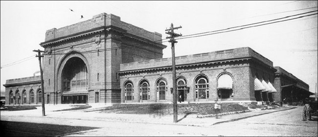
(Chattanooga-Hamilton County Bicentennial Library)
This lesson is part of the National Park Service’s Teaching with Historic Places (TwHP) program.
When Glenn Miller and his orchestra introduced the famous song "Chattanooga Choo- Choo" in 1941, the Tennessee city it referred to had been a railroad center for nearly a century. Mack Gordon’s lyrics from the Academy Award- nominated song trace the progress of the "Choo-Choo" from New York’s Pennsylvania Station south to Chattanooga’s sprawling Terminal Station, making “Track 29” famous. Arriving passengers were greeted by the bustle, sounds, smells, and opulence of a grand building that was a tribute to the town’s importance as a southeastern transportation hub. Around Terminal Station were miles of crisscrossing tracks, acres of rail yards, and dozens of buildings that housed the industries, restaurants, hotels, shops, offices, and people of a town that evolved as a direct result of the rail industry.
Railroads both influenced and reflected American settlement and development from the 1830s to the 1950s. In the cities, they shaped and stimulated economic growth, planning, and architecture. Today, although railroads have lost much of their economic importance, evidence of their influence remains. Even in towns where trains no longer run, buildings, tracks, train beds, and place names attest to the enduring legacy of America’s rail history.
![]()
About This Lesson
This lesson is based on the National Register of Historic Places registration files "Market and Main Streets Historic District" and "Terminal Station," and other sources on Chattanooga and the rail industry. It was written by Caneta Skelley Hankins, a project coordinator for the Middle Tennessee State University Center for Historic Preservation in Murfreesboro, Tennessee. TwHP is sponsored, in part, by the Cultural Resources Training Initiative and Parks as Classrooms programs of the National Park Service. This lesson is one in a series that brings the important stories of historic places into the classrooms across the country.
Where it fits into the curriculum
Topics: The lesson could be used in units on the American Industrial Revolution, the growth of urban America, or in a geography course. Students will strengthen their ability to analyze and interpret primary and secondary sources, and reinforce curriculum objectives related to geography, language arts, social studies, history, and the visual arts.
Time period: Mid-19th century to mid-20th century
United States History Standards for Grades 5-12
Chattanooga, Tennessee: Train Town relates to the following National Standards for History:
Era 4: Expansion and Reform (1801-1861)
-
Standard 2A- The student understands how the factory system and the transportation and market revolutions shaped regional patterns of economic development.
-
Standard 2B- The student understands the first era of American urbanization.Era 6: The Development of the Industrial United States (1870-1900)
-
Standard 1A- The student understands the connections among industrialization, the advent of the modern corporation, and material well-being.
-
Standard 1B- The student understands the rapid growth of cities and how urban life changed.
Curriculum Standards for Social Studies
(National Council for the Social Studies)
Chattanooga, Tennessee: Train Town relates to the following Social Studies Standards:
Theme II: Time, Continuity and Change
-
Standard C - The student identifies and describes selected historical periods and patterns of change within and across cultures, such as the rise of civilizations, the development of transportation systems, the growth and breakdown of colonial systems, and others.
Theme III: People, Places, and Environment
-
Standard B - The student creates, interprets, uses, and distinguishes various representations of the earth, such as maps, globes, and photographs.
-
Standard D - The student estimates distance, calculates scale, and distinguishes other geographic relationships such as population density and spatial distribution patterns.
-
Standard G - The student describes how people create places that reflect cultural values and ideals as they build neighborhoods, parks, shopping centers, and the like.
-
Standard J - The student examines, interprets, and analyzes physical and cultural patterns and their interactions, such as land use, settlement patterns, cultural transmission of customs and ideas, and ecosystem changes
-
Standard I - The student describes ways that historical events have been influenced by, and have influenced, physical and human geographic factors in local, regional, national, and global settings.
-
Standard K - The student proposes, compares, and evaluates alternative uses of land and resources in communities, regions, nations, and the world.
Theme VII: Production, Distribution, and Consumption
-
Standard A - The student gives and explains examples of ways that economic systems structure choices about how goods and services are to be produced and distributed.
-
Standard B - The student describes the role that supply and demand, prices, incentives, and profits play in determining what is produced and distributed in a competitive market system.
-
Standard I - The student uses economic concepts to help explain historical and current developments and issues in local, national, or global contexts.
Theme VIII: Science, Technology, and Society
-
Standard A - The student examines and describes the influence of culture on scientific and technological choices and advancement, such as in transportation, medicine, and warfare.
-
Standard B - The student shows through specific examples how science and technology have changed people's perceptions of the social and natural world, such as in their relationships to the land, animal life, family life, and economic needs, wants and security.
Theme X: Civic Ideals, and Practices
-
Standard C - The student locates, accesses, analyzes, organizes, and applies information about selected public issues - recognizing and explaining multiple points of view.
-
Standard E - The student explains and analyzes various forms of citizen action that influence public policy decisions.
-
Standard F - The student identifies and explains the roles of formal and informal political actors in influencing and shaping public policy and decision-making.
Objectives for students
1) To understand how geography and promotion combined to encourage the growth of Chattanooga, Tennessee;
2) To analyze how railroads shaped the downtown organization and architecture of Chattanooga and of cities in general.
3) To study the impact of railroads in the local community and to identify railroad-related buildings and structures that survive today.
Materials for students
The materials listed below either can be used directly on the computer or can be printed out, photocopied, and distributed to students. The maps and images appear twice: in a low-resolution version with associated questions and alone in a larger, high-resolution version.
1) one map showing Terminal Station and the surrounding area;
2) two readings on the history, location, development, and railroad-related architecture of Chattanooga;
3) one excerpt from an 1896 brochure promoting the city of Chattanooga;
4) one drawing of Terminal Station and surrounding area;
5) four photos of Terminal Station and other buildings related to the railroad industry.
Visiting the site
The Chattanooga Choo-Choo is open to the public. For brochures, additional information, or reservations, contact the Chattanooga Choo-Choo, 1400 Market Street, Chattanooga, TN 37402. Although most of the buildings in the Market and Main Streets Historic District are private businesses and not necessarily open to the general public, the neighborhood is easily seen from the public streets. Some buildings now serve as restaurants or shops and welcome visitors. For a listing of the restaurants and shops in the Main and Market Streets Historic District, contact the Chattanooga Area Convention and Visitor’s Bureau, 1001 Market Street, Chattanooga, TN 37402.
Getting Started
Inquiry Question
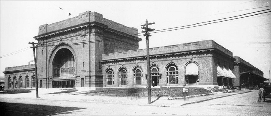
For what purpose do you think this building
was constructed? What might be a good use for this building today?
Setting the Stage
For about 100 years, beginning in the mid-19th century, trains were the primary means of transportation for people and freight. The railroad industry played an integral part in the shaping of the American landscape, in the development and history of towns along its routes, and in the lives of people who were employed by it, traveled on trains, or whose work and business were associated with it. The railroad has long been a popular topic for American literature and music, and its role in cultural, economic, and political history continues as a subject of serious scholarship.
England developed the first railroads in the 1820s. By the 1830s businessmen, politicians, engineers, and speculators along the Atlantic coast of the U.S. were already eagerly promoting this new form of transportation. Two factors primarily determined where the tracks would be built. Geography was the first: rail lines followed, whenever possible, traditional passages over difficult terrain first used by American Indians and later by trappers and settlers. The location of roads and waterways which could transport goods to and from rail lines also affected where stations would be established. The second factor centered on what historians refer to as "boosterism." Towns competed fiercely with each other as they tried to draw the railroad toward them. First, they often bought stock in a railroad to encourage it to lay its tracks through their area; later they helped lines that wanted to expand. Cities also actively promoted themselves as centers for industry. By stimulating local business they would increase traffic and therefore profits for the railroad. Assisting the railroads was good business for local towns. Trains brought employment, both directly and through businesses dependent on transportation connections.
Chattanooga, Tennessee, illustrates the importance of both factors. Its location--on the Tennessee River, at a natural break where the Allegheny and Cumberland ranges converged--made it an appealing site. By laying their tracks through Chattanooga, the emerging rail industries hoped to reach and dominate lucrative markets west of the mountains. The city built on these advantages by presenting itself to potential residents and investors, particularly after the Civil War, as an ideal place to live and work.
Locating the Site
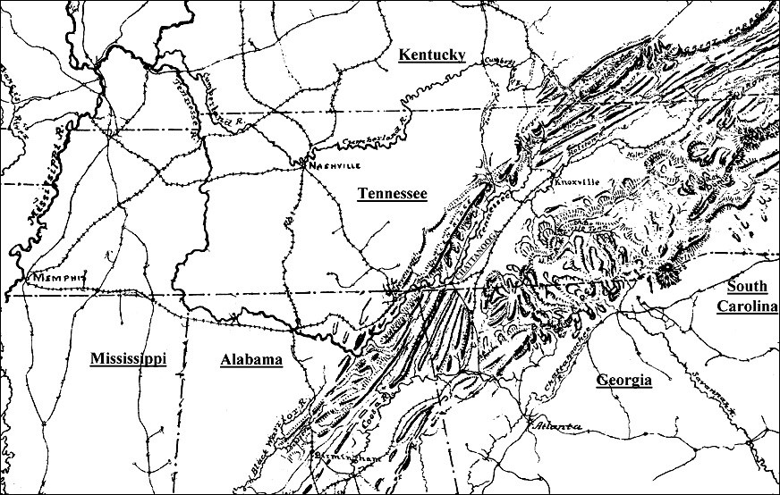
Map 1: Tennessee and surrounding region.
(Library of Congress)
Map 1 is based on a map Jedidiah Hotchkiss, a mapmaker for the Confederate army, drew in 1880. Chattanooga stands at the southern gateway to the Cumberland and Allegheny Mountains. It also has a natural port on the Tennessee River.
Questions for Map 1
1. What states are near Chattanooga?
2. What prominent natural features are near Chattanooga?
3. How do these features help explain Chattanooga's appeal as a rail center?
4. In the 1840s, a resident of Chattanooga said the city was located at the "funnel of the universe." What did he mean?
5. Can you find another location on this map that has similar natural advantages?
Determining the Facts
Reading 1: The Railroad Helps Build a Town: Chattanooga, Tennessee
Among the Creek Indians, who for centuries controlled the area where today Georgia, Tennessee, and Alabama come together, the word "Chado-na-ugsa" meant "rock that comes to a point." The name referred specifically to what is now called Lookout Mountain, a peak from which one can see for hundreds of miles. Chado-na-ugsa was a landmark well known to generations of Creek and Cherokee, who fished and traveled by the Tennessee River and who hunted and trapped in the surrounding mountains.
In the early 19th century, Daniel Ross, a Cherokee Indian of mixed white and Indian ancestry, founded a trading post at the site of present-day Chattanooga. His son John, who became Chief of the Cherokee Nation, expanded the business. After American Indians were forced west on the infamous Trail of Tears, whites renamed "Ross’s Landing" Chattanooga and in 1839 incorporated it as a city.
Businessmen moved quickly to capitalize on the city’s geographic advantages. In the decade before Chattanooga was incorporated, railroads had already begun to spread along the Atlantic coast. Businessmen, investors, and politicians were seeking ways to reach the farmers in the Tennessee River Valley, who produced large quantities of grain and livestock. Transporting these products to different markets proved difficult. The Tennessee River, which flowed toward the Mississippi, turned dangerous just west of Chattanooga, and rough roads through mountains made land travel expensive and slow.
In the late 1830s investors in Georgia began to build tracks which would bring goods to Savannah, the state’s major port. From there the products could be shipped around the world. They were racing to catch up with their main rival, Charleston, South Carolina, which already received goods through a 140-mile supply network of rails that continued to grow. In order to compete, Georgia started building the Western & Atlantic Railroad leading north and west from Savannah.
By the mid-1840s the Western & Atlantic was approaching Chattanooga, whose port on the Tennessee River made it a logical site for a rail center. Residents of Chattanooga recognized the impact the railroad would have on their town. One citizen wrote to a friend in 1847, "If Georgia fails to finish the road or make the appropriation for its completion all is flat in Chattanooga, but the general belief is that she will do it. And then we expect a rush to this place."¹
The first train moved across Georgia into Tennessee in 1849. A speaker at the celebration of the event expressed the significance of the ceremony: "With united hands, let Georgia and Tennessee join on this occasion in mingling the waters of the Atlantic and the Mississippi...." He further noted that the railway would "open the way for us to the far West by Nashville and shall establish communication with the North through the valley of the Holston [River]."²
As the terminus of the Western & Atlantic Railroad and a main junction for other lines, Chattanooga was the keystone in the southern rail system. Over the next decade, other rail lines began purchasing land in order to construct tracks north, east, and southwest out of Chattanooga. The first passenger station was built in 1858, and the Union Station and Car Shed, for freight shipping and for the maintenance of the railroad cars respectively, were constructed the same year.
Because of the growth fostered by the railroads, Chattanooga began to develop into a city. Hotels, restaurants, and saloons appeared for the convenience of travelers and tourists. Warehouses for grain, timber, cotton, and other raw materials were built near the rail yards, as were corrals for holding livestock. Businessmen created factories for iron working, furniture manufacturing, and textile production, then shipped their products out on the rails. These businesses drew more people to Chattanooga; as the population increased, more streets and lots for new homes were laid out. Shops, schools, and churches appeared, as did offices for doctors, lawyers and government agencies.
The Civil War temporarily halted this growth. Chattanooga’s strategic location made it a key site for military operations for both North and South. Some of the hardest fought and most deadly battles of the war were fought in and around Chattanooga at places called Chickamauga, Missionary Ridge, and Lookout Mountain. Union troops more often controlled the rail lines in and out of Chattanooga, but Confederates often damaged or destroyed the tracks in an attempt to halt the influx of federal soldiers and supplies.
Within a year of the war’s end, Union troops had rebuilt the rails and the city’s rapid growth resumed. Over the next 40 years Chattanooga became one of the leading examples of the industrial and commercial revolution that characterized the "New South."
Questions for Reading 1
1. What were the advantages of building railroads through Chattanooga in the 1840s?
2. How did people in Tennessee River Valley travel and transport goods before railroads were built? What were the disadvantages of these methods of transportation?
3. Why was Chattanooga considered a good location for a rail center?
4. Why did cities compete for railroads?
5. What were some of the ways in which the railroad impacted Chattanooga?
6. Why was Chattanooga such an important strategic location during the Civil War?
Reading 1 was compiled from Miranda Roche, "Market and Main Streets Historic District" (Hamilton County, Tennessee) National Register of Historic Places Registration Form, Washington, D.C.: U.S. Department of the Interior, National Park Service, 1992; and Gilbert E. Govan and James W. Livingood, The Chattanooga Country, 1540-1976: From Tomahawks to TVA (Knoxville: University of Tennessee Press, 1977).
¹Gilbert E. Govan and James W. Livingood, The Chattanooga Country, 1540-1976: From Tomahawks to TVA (Knoxville: University of Tennessee Press, 1977), 130.
²Govan and Livingood, 132.
Determining the Facts
Reading 2: Promoting Chattanooga
The following excerpts are from Chattanooga and Hamilton County, Tenn., a guide published by the city government in 1896.
Many cities and counties possess some of the advantages that are found here, perhaps to an equal degree, but no other city or county in America possesses greater advantages. Chattanooga has every essential to future greatness, viz: healthful location, fertile soil, prosperous surroundings, abundant mineral and timber wealth, beautiful scenic attractions, rich historic associations, unsurpassed transportation facilities, a salubrious climate and a progressive and enlightened citizenship; the county has the most magnificent system of roads in the Southern states....
No city in the whole southern country has transportation facilities equal to Chattanooga. The Tennessee river, which almost entirely surrounds the city, is now open for navigation and vessels of six feet draught ply from Chattanooga to Ohio and Mississippi ports. Eleven separate and distinct lines of railway terminate here, diverging like the spokes of the wheel, to all points of the compass, representing five rival railway systems, close competitors, and wholly independent. The sharp competition between water and rail has materially reduced freight rates, and they become lower as the river traffic develops....
Chattanooga is the natural commercial entrepot of a district 200 miles square, in which 2,500,000 people reside. The river bottoms yield rich harvests of cereals and grasses, the mountains and ridges grow small fruits in abundance; over 1,000,000 pounds of berries, small fruits and early vegetables are annually shipped from Chattanooga to Northern markets, and Hamilton county is becoming one of the most important producers of early strawberries, tomatoes, sweet potatoes, grapes, and small fruits in the Southern states. Within 75 miles of Chattanooga nearly 100,000 bales of cotton are annually raised; the culture of tobacco and of hops is becoming an important industry, and peanuts and other leguminous plants are being extensively cultivated.
The area tributary to Chattanooga, is perhaps, the richest mineral region in America, as respects both quantity and diversity of resources. Coal and iron, limitless in quantity and of a uniformly high grade, are found in every hill and mountain; gold, silver, copper, zinc, lead, mica, asbestos, and gem stones are profitably mined within 75 miles of Chattanooga; white, black, and mottled marble, and good building stone are successfully quarried. Cement, slate, calcerous lime, kaolin, sand and potter’s clay are also found in inexhaustible quantities, and are being successfully operated. Poplar, pine, gum, cherry, cedar, ash, oak, hickory and other hard woods, are easily accessible from Chattanooga, in large quantities.
Questions for Reading 2
1. According to this brochure, what advantages did Chattanooga offer businessmen?
2. Which of the city's claims seem exaggerated?
3. If the city offered so many benefits, why did they have to advertise? Wouldn't investors have already known what a good place it was?
4. Why would the city mention nonbusiness features such as "scenic attractions" and "a progressive and enlightened citizenship"?
5. Do you think a brochure like this would have influenced businessmen's decisions about where to locate?
Reading 2 was excerpted from George W. Ochs, Chattanooga and Hamilton County, Tenn. (Chattanooga: Times Printing, 1896), 3-4.
Determining the Facts
Reading 3: Terminal Station
After the Civil War American railroads expanded rapidly. In the 1860s the country had 53,000 miles of track. By the turn of the century, it had nearly 200,000 miles, more than in all of Europe. Growth occurred particularly in the West and the South, linking those regions more closely to the industrial Northeast.
Chattanooga was one of the cities that benefited most from railroad expansion. In 1870 there were 58 industries in Chattanooga. By 1910 there were more than 300. Over the same period industrial employment in the city rose from 2,100 to 22,000. Virtually all these businesses were dependent on the railroad for customers or transportation of goods.
By 1910, 10 lines considered Chattanooga a key part of their networks. The Southern Railway alone controlled tracks which headed out of the city in four different directions. Rails connected Chattanooga to all the largest ports in the South: New Orleans, Mobile, Pensacola, Jacksonville, Savannah, Charleston, and Norfolk. Tracks also reached major inland cities such as Atlanta, Charlotte, and Memphis.
This growth created demand for new facilities. By the early 1880s the city had outgrown its original 1858 station. An 1882 replacement lasted only six years before it also became too small. In 1888 an old freight depot at the corner of 13th and Market Streets was converted to the Central Passenger Station. During this period freight facilities expanded and by 1900, the area near the Central Station housed three different depots serving commercial and industrial traffic.
Within 25 years Chattanooga again needed a larger passenger depot. In 1905 the Southern Railway hired New York architect Don Barber to design what became known as "Terminal Station." This building, which opened in 1909, handled only passenger traffic and "express," or small package shipments.
From its opening Terminal Station was one of the city’s grandest buildings (see photo 1). Its most distinguishing architectural feature was the brick arch framing the entrance. At the time it was built, it was said to be the largest brick arch in the world. The station included a main waiting room, bathrooms, ticket office, and other services. It was one story throughout; this meant that the center section, which featured a dome and skylight, had an exceptionally high ceiling. Large brass chandeliers manufactured in New York City hung from brightly painted ceilings. Two Chattanooga-based firms, brick producer Southern Clay Manufacturing Company and timber supplier Willingham and Company, provided most of the materials used in the station’s construction. Prior to its official opening, Terminal Station was praised in an article in the Daily Times on December 10, 1908:
Chattanoogans who have not visited the new terminal station since it has been practically completed have a big treat in store. Few persons, if any, who have not visited the station within the past few weeks have any conception of its grandeur and entire fitness for handling passenger traffic. To properly appreciate the new railroad plant a person should spend a few minutes at the Central shed and study the conditions there and then go to the new station. The contrast is great.
Terminal Station enjoyed a long and busy history as the city’s main passenger terminal. The station was especially important during World War II, when as much as 90 percent of the nation’s traffic went by rail. In 1944 a complete renovation and redecoration was begun to modernize the station. By the next decade, however, the railroads were receiving stiff competition from airlines, automobiles, and long-haul trucks. As railroad traffic declined, so did the area around Terminal Station. The last passenger train left Terminal Station in 1970. By that time many businesses in the area around the station were already closed and boarded up.
In 1972 local businessmen formed a partnership and began the rehabilitation of the building they renamed the Chattanooga Choo-Choo after the 1940s song. Although the project has had problems over the years, today the Choo-Choo is a successful convention center and hotel with restaurants, shops, and even some railroad cars renovated for overnight accommodations. The success of the Choo-Choo has also brought about a renewal of the area around the station. Owners of restaurants, shops, offices, and other businesses have returned to restore and occupy many of the historic buildings in the district. Meanwhile, trains continue to roll in and out of Chattanooga daily. The past, the present, and the future come together in the railroad industry and its place in the heritage of Chattanooga.
Questions for Reading 3
1. Why did Chattanooga have to build so many freight and passenger stations?
2. Why might the Southern Railway have hired a New York architect to design Terminal Station?
3. What were the areas inside the station used for?
4. According to the Daily Times article, how did the Terminal Station compare with the old Central Passenger Station?
5. What is the tone of the article? In other words, how did the paper want the city to feel about its new station?
6. What factors brought about the decline of the railroad industry?
7. Why did the decline and revival of the Terminal Station have such a dramatic effect on the surrounding area?
8. Why was it important to revitalize and rehabilitate Terminal Station?
Reading 3 was compiled from Ellen Beasley, "Terminal Station" (Hamilton County, Tennessee) National Register of Historic Places Registration Form, Washington, D.C.: U.S. Department of the Interior, National Park Service, 1972; and Miranda Roche, "Market and Main Streets Historic District" (Hamilton County, Tennessee) National Register of Historic Places Registration Form, Washington, D.C.: U.S. Department of the Interior, National Park Service, 1992.
Visual Evidence
Photo 1: Chattanooga Terminal Station, 1935.

(Chattanooga-Hamilton County Bicentennial Library)
Questions for Photo 1
1. What architectural features of Terminal Station create a sense of grandeur?
2. Why would it be important to distinguish the terminal by making the design elaborate? What does the building tell you about the influence and role of the railroad industry in Chattanooga?
3. What is the building being used for now? Is this an appropriate use for this building?
Visual Evidence
Drawing 1: Terminal station and surrounding area.
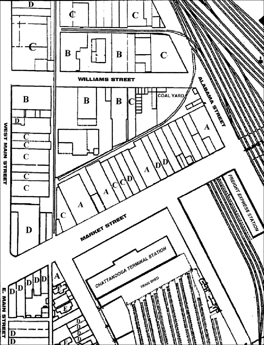
The terminal and other nearby rail facilities directly affected the way the surrounding neighborhood was built. Each of the letters on the map identifies a specific use: hotels (A); factories (B); warehouses (C); stores (D); and residences (E). Using this key, answer the following questions about how owners of these facilities chose their locations.
Questions for Drawing 1
1. Study Drawing 1, which shows the area around Terminal Station. Locate Terminal Station and identify any other rail facilities.
2. Which owners would want to be close to the station?
3. Which owners would want to be close to the tracks?
4. Which owners would want to be away from the railroad?
5. Which owners would be able/willing to pay the most for a specific location?
6. Which owners would want their business to be on a main street? Which facilities could be on alleys?
Visual Evidence
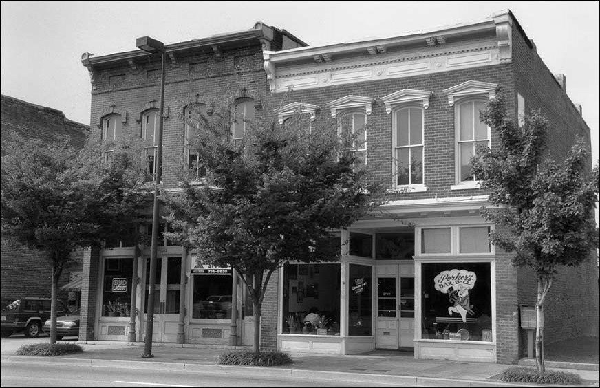
Photo 2: 1260 and 1263 Market Street, Chattanooga.
(Photo by Carroll Van West. Middle Tennessee State University Center for
Historic Preservation Collection)
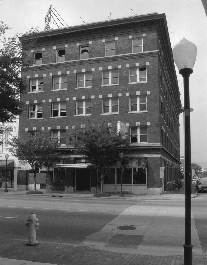
Photo 3: 1401 Market Street, Chattanooga.
(Photos by Carroll Van West. Middle Tennessee State University Center for Historic Preservation Collection)
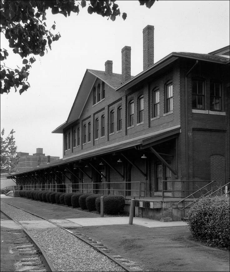
Photo 4: 1140 Newby Street, Chattanooga.
(Photos by Carroll Van West. Middle Tennessee State University Center for Historic Preservation Collection)
Many of the structures in this area have changed uses since the early part of the century.
Questions for Photos 2-4
1. For what purpose do you think each of the buildings in Photos 2-4 was originally built? How can you tell?
2. Determine where each of the buildings might have been located in Drawing 1. Which buildings would be closer to Terminal Station? Which would be closer to the railroad tracks?
3. Considering the rehabilitation of the area around Terminal Station, how might these buildings be used today?
Putting It All Together
Chattanooga provides a particularly good example of the railroad’s importance to American development, but evidence of this influence exists across the country. The following activities should help students better understand the many ways railroads shaped and continue to affect U.S. history and culture.
Activity 1: The Roles of Geography and Promotion
It is easy to claim that Chattanooga’s success was "natural," that geography guaranteed its success. Yet many other sites with physical advantages were never able to capitalize on them. Cairo, Illinois, for example, never developed into a major city despite its location at the confluence of the Ohio and the Mississippi Rivers.
Begin by having students create two lists from the materials they covered in the lesson. The first should describe the natural features that would make Chattanooga a good place for businesses to locate. The second should include those man-made factors that offer other benefits. Then have each student write a paragraph on whether man or nature was more important in the city’s growth. Have them discuss their answers. The following questions can be used to facilitate the discussion: Would the man-made advantages alone have been able to attract business? Should active promotion to attract business be included in the man-made advantages? Would the natural advantages still appeal to businesses today? Do towns and cities still actively encourage businesses to settle there today? If so, what incentives do they provide?
Activity 2: Literature, Art, and Music
Try to locate a recording of "Chattanooga Choo-Choo" by Glenn Miller and his orchestra. (Many of his recordings have been re-released.) Play the song for the class. On a map of the United States, have students trace the route described in the song.
Continue by having students find other places in popular culture where railroads appear. Have them develop lists of books, songs, poems, movies, and artworks that are about trains. Why were--and are--trains such popular subjects?
Activity 3: Researching Your Community’s Railroad History
Have students find out more about the history of railroads in their community by investigating local and state histories, newspapers, and photograph collections at the library. Ask them to find answers to the following questions: When did the railroad first arrive? How did that happen? How did the community respond? If the railroad never appeared, find out why.
Then have students examine the long-term effects of the railroad by completing the following exercises: What railroad-related buildings, structures, place names, or features still exist in your community? Photograph and identify them. Look for old photographs of buildings that have been demolished. Interview people employed by the railroad or by businesses that depend on the railroad. Ask them questions about their work and the significance of the railroad to the community and to their lives. Discuss the current impact, or reasons for lack of impact, of the railroad on your community.
Finish the activity by asking students to consider what the main transportation routes in their community are today. Are shopping areas of their town related to these routes? Are those connections similar to the ones with the railroad? Have students ask local business owners how important transportation is to their business, and how it is provided. See if they can determine whether the availability of transportation affected decisions about where to locate or relocate local businesses.
Chattanooga, Tennessee: Train Town--
Supplementary Resources
By looking at Chattanooga, Tennessee: Train Town, students will understand how Chattanooga's development illustrates the importance of railroads to American cities. Those interested in learning more will find that the Internet offers a variety of interesting materials.
Transportation History:
Allegheny Portage Railroad National Historic Site
Allegheny Portage Railroad National Historic Site is a unit of the National Park System. The park's expanded Web pages examine subjects related to transportation history, canals, the 1800s, and more.
Mojave National Preserve Railroads
Mojave National Preserve Railroads is a unit of the National Park System. The park's web page discusses the importance of transportation in our nation's history, particularly the influence of the Burlington Northern/Santa Fe on the Mojave National Preserve. This railroad provided the main economic lifeline for miners, ranchers, and homesteaders by creating a link to the national economy.
Central Pacific Railroad Photographic History Museum
The Central Pacific Railroad Photographic History Museum Web site documents through both text and pictures the completion of the first transcontinental railroad. When it was completed, the rails of the Union Pacific and the Central Pacific Railroad were joined, completing a coast-to-coast connection. The site also offers links to other non-profit Web sites detailing laws and events that help dictate the history of trains and railroads.
Library of Congress:
American Memory Collection
Search the American Memory Collection Web page for a variety of historical resources on the "Chattanooga, railroad," "Chattanooga," and "railroads." Included on the Web site are historic photographs, maps, sheet music, articles, and documents on everything from Terminal Station to Chattanooga's role in the Civil War.
American Railway Maps, 1828-1900
View the Library of Congress's American Memory Collection of Railway Maps by searching with keywords or browsing by geographical location. On the home page, scroll down to useful links on the "History of Railroads and Maps," "Related Resources" and "Learn More About It!"
Railroad Terminals and Stations:
Ohio Railroad Stations Past and Present
This Web page provides links to numerous interactive databases of existing railroad stations in Ohio, Pennsylvania, New York, and several other states. The information the database provides about each station includes the original city in which it was located, the railroads it serviced, its current location, how it is currently being used, and more. Also included are many photographs that provide a frame of reference for different architectural railroad station styles in the United States.
The New York Central Terminal of Buffalo, New York
Visit this Web site that provides an in-depth look at the creation and history of the New York Central Terminal of Buffalo, NY. Included on the site are details about the rise and decline of the use of railroads in America as a form of mass transit.
Tags
- tennessee
- tennesse history
- national register of historic places
- nrhp listing
- teaching with historic places
- twhp
- railroad
- industrial revolution
- industrial history
- industrialization
- tennessee train town
- national historic district
- mid 19th century
- gilded age
- science
- migration and immigration
- chattanooga
- science and technology
- transportation
- progressive era
- mid 20th century
- twhplp
