Northern California’s Shasta Dam is a keystone of the Bureau of Reclamation’s huge Central Valley Project, which involves 35 of California's counties and two major watersheds: those of the Sacramento River on the north and the San Joaquin River on the south. Together, these watersheds extend for nearly 500 miles, feeding the heart of California’s long, flat Central Valley, one of the most fertile and productive garden spots in the world. Grown here are more than 250 varieties of crops, including the almonds, artichokes, avocados and wine grapes that make California famous for more than movie stars.
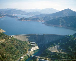
Shasta Dam, dwarfed only by Hoover and Grand Coulee dams when it was completed on the Sacramento River in 1945, is breathtaking not only for its great size, but for its majestic setting in the southern range of the Cascades. The 602 foot-high, concrete, curved gravity dam holds back an immense blue reservoir, Lake Shasta, which boasts a 365-mile shoreline nestled amid evergreen hills and the snow-covered volcanic peak of Mount Shasta.
Shasta not only stores water to irrigate valley farms to the south, but it protects them from floods and the intrusion of saline ocean water that flows in from San Francisco Bay. The dam also provides water for towns and industries and furnishes hydroelectric power. Shasta is only one of 20 dams and reservoirs on Reclamation’s Central Valley Project, but it has been a key component from the beginning.
The project did not begin with the Federal Government, but with the State of California, which long recognized the benefits to be had by connecting the thirsty Central Valley with the state’s water-rich mountains. Stretching 400 miles from north to south, the valley’s precipitation fluctuates significantly. While the southern end below Bakersfield receives an average of only five inches of rain a year, the northern area around Redding gets more than 30. Then again, because most of the rain and snow falls from December through April, the Central Valley is subject to flooding in the spring or prolonged droughts. One drought was so severe in 1863-64 that it devastated California’s cattle industry, which was once prominent in the region’s history.

Development of irrigation in the valley began on a large scale in the 1850s, following the discovery of gold that brought hundreds of thousands of people from around the world to California’s mining regions. Until then, the area around today’s Shasta Dam was largely unpopulated by people of European descent. Among the Indian groups that called the region home for thousands of years were the Hupa, Achumawi, Achomawi and the Shasta, whose huge territory extended north into present-day Oregon. This is a land of many rivers and streams--the Trinity, Pit, McCloud and California’s biggest river of all, the Sacramento, which rises in the Klamath Mountains and flows 400 miles south into the Sacramento-San Joaquin Delta, some 80 miles east of San Francisco. Many waterways converge in the delta, including California’s second largest river, the San Joaquin, which enters the delta from the south. Together, the Sacramento and San Joaquin flow into the Suisun Bay, then west into San Francisco Bay and out the Golden Gate to the Pacific Ocean.
Tapping these primary rivers and their many tributaries for irrigation began in earnest in the 1850s when private interests built canals to serve areas near the rivers. Local projects undertaken by communities, irrigation districts and public utilities followed. Efforts at a comprehensive plan for the Central Valley began in 1873 with a report by U. S. Army Corps of Engineers, followed by many other studies. In 1919, a plan was submitted to the governor of California, which spurred statewide interest and led to the first of a series of state appropriations to investigate ways to conserve, control, store and distribute the valley’s water. In 1931, California’s Division of Water Resources submitted what was known as the State Water Plan to the state legislature, which passed the California Central Valley Project Act in 1933 in the midst of the Great Depression. California voters approved the project, but when the bonds needed to finance construction proved impossible to sell, California looked to the Federal Government for help.
Assuming control, the Federal Government initiated its Central Valley Project with plans for two major dams, one at each end of the valley--Friant Dam, completed in 1942 on the San Joaquin north of Fresno, and Shasta (originally known as Kennett Dam) on the Sacramento River, north of Redding.
Reclamation opened bids for Shasta Dam on June 1, 1938, the undertaking so big that groups of contractors, as they had done on the Hoover Dam contract, pooled their skills and financial resources in an effort to land the job. Pacific Constructors Inc. (PCI), led by the prominent Los Angeles outfit of L. E. Dixon, won the job with a bid of $36.9 million. Soon to come on board as general superintendent was engineer Frank Crowe, who had taken charge at a number of other prominent Reclamation dams: Arrowrock, Hoover and Parker among them.

A crew that eventually totaled 4,700 men excavated millions of tons of granite from the hillsides and built a 9.6-mile-long conveyor belt, which operated 24 hours a day, transporting aggregate from a quarry nine miles away. A major undertaking was relocating 30 miles of Southern Pacific Railroad track, which ran right through the construction site. To reroute the track, crews constructed bridges, trestles and tunnels, including one tunnel later used to divert the river around the site so the dam could be built.
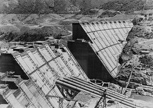
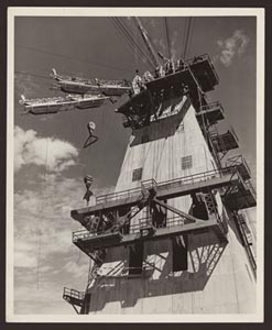
The railroad delivered cement, which was mixed with the aggregate and river water at a plant upstream, the wet concrete then hurried to the construction site on a huge cableway system that reached all parts of the dam. By July 1940, crews were hard at work pouring concrete from huge buckets into wooden forms that created a series of interlocking, 50-foot-by-50-foot blocks for the dam face. “Great care was taken,” historian David P. Billington writes, “to ‘vibrate’ the wet concrete to ensure that it completely filled the forms without leaving any voids or airspaces that would tend to weaken the structure.” Once the concrete hardened, which took about 48 hours, the wooden form was loosened and configured to handle the next five-foot lift of concrete.
By August 1942, four million cubic yards of concrete (or 807 million gallons) had been placed, and by the summer of 1943, the dam was taking final shape. Water storage began in Lake Shasta in February 1944, and the last bucket of concrete was poured on January 2, 1945. When Shasta’s five-generator plant came online in 1950, the project was complete.
At 602 feet, Shasta at the time was the second highest concrete dam in the world (behind Hoover at 726.4 feet) and was rivaled in mass only by the gargantuan Grand Coulee Dam, then under construction on the Columbia River in Washington. Shasta Dam is 883 feet thick at its base, 30 feet thick at its crest, and contains 6.5 million cubic yards of concrete weighing 15 million tons. At 487 feet long, its spillway was the largest manmade waterfall in the world, though it is eclipsed today by those at other dams, including Three Gorges Dam in China and Itaipu in Brazil.
Like those larger dams, Shasta also has been the subject of criticism, especially for its impact on the winter run of Chinook Salmon (Oncorhynchus tshawytscha), which are listed as endangered under the Endangered Species Act. To protect the salmon but still minimize the loss of power generation, a multi-faceted Temperature Control Device, which ensures the release of cold water for the benefit of the salmon, was completed in 1997 on the face of the dam.
Visit the National Park Service Travel Bureau of Reclamation's Historic Water Projects to learn more about dams and powerplants.
Last updated: January 13, 2017
