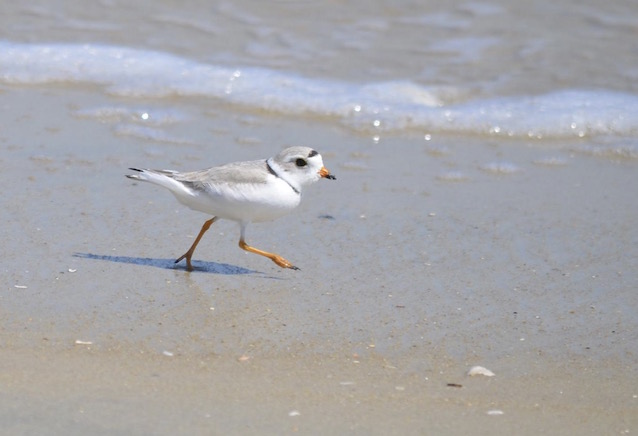
At Cape Hatteras National Seashore monitoring for piping plovers began in early March 2015. The first nests of the 2015 breeding season were discovered on April 19th, while the last nest hatched on July 1st. Twelve breeding pairs and seventeen nests (including renests) were identified during the season. Two chicks successfully fledged resulting in a fledge rate of 0.17 chicks per breeding pair.
National Park Service
Introduction
Routine monitoring of PIPL at CAHA began in 1985. The Atlantic population was listed as threatened under the Endangered Species Act in 1986. Monitoring focused on locating and protecting breeding territories to aid in determining nest and brood success. This report contains a summary of monitoring results for the 2015 breeding season, comparisons to results from previous years, and the resource management activities undertaken for PIPL in 2015.
On February 15, 2012 the ORVMP was enacted at CAHA. It was developed from 2007-2012 and was accompanied by a special regulation detailing requirements for off-road vehicle (ORV) use at CAHA. A copy of the ORV Management Plan and other related documents are available electronically at: https://parkplanning.nps.gov/caha. The ORV Management Plan includes establishment of pre-nesting closures and buffer requirements for nesting birds and chicks as well as the requirement for an ORV permit to drive on CAHA beaches.
The National Defense Authorization Act of 2014 directed CAHA to conduct a review of established wildlife buffers and modify them, based on peer-reviewed science, to the shortest duration possible and the smallest area possible. The Environmental Assessment (NPS, 2015) was signed in June of 2015 with a target implementation date of field season 2016. The modified nesting buffers for PIPL were reduced from 75 m to 50 m which somewhat aligns with the current Recovery Plan. Buffers for unfledged chicks will range from 500 m to 200 m contingent on the availability of staff to monitor chicks continuously while the beaches are open for driving. Should staff not be available for intensive monitoring, the buffer will revert to 1000 m.
The Record of Decision indicates that CAHA will "conduct a systematic review of data, annual reports, and other information every 5 years, after a major hurricane, or if necessitated by a significant change in protected species status (e.g. listing or de-listing), in order to evaluate the effectiveness of management actions in making progress toward the accomplishment of stated objectives". As part of the Reporting Requirements of the Biological Opinion (BO) for the Off-road Vehicle Management Plan (November 15, 2010), "an annual report detailing the monitoring and survey data collected during the preceding breeding season (as described in alternative F, in addition to the additional information required in the… Terms and Conditions) and summarizing all piping plover, seabeach amaranth, and sea turtle data must be provided to the Raleigh Field Office by January 31 of each year for review and comment."
Methods
Shorebird Management Areas
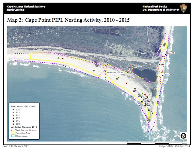
A required yearly habitat assessment was conducted from February 23 – March 6, prior to the onset of the breeding season. This assessment, along with historic nesting locations, was used to determine the boundaries for pre-nesting closures (Appendix A, Maps 1-4). These sites were then posted with symbolic fencing consisting of wooden posts, bird usage signs prohibiting entry, string, and flagging tape by March 15, as required by the ORV Management Plan. While pre-nesting closures minimize disturbance in potential breeding areas, they also enable birds to establish territories and nest in their preferred habitat. Bodie Spit, Cape Point, South Beach, North Ocracoke, and South Point all contained potential and/or historic nesting habitat for PIPL.
The pre-nesting closures were modified throughout the season in order to meet the buffer requirements of the ORV Management Plan and to provide adequate protection for nesting birds and broods. Buffers for PIPL included a 75 m buffer for breeding behaviors (scraping, territorial, courtship, or mating) and for nests. When unfledged chicks are present, this buffer is either expanded to 1000 m in ORV areas or 300 m in pedestrian areas. A closure was modified when breeding behavior was observed within close proximity of an existing closure, or if an existing scrape, nest, or chick was documented to have an insufficient buffer.
Monitoring
Seasonal monitoring for PIPL began in early March. Predator exclosures, which have been used at CAHA since 1994 to reduce predatory pressure on PIPL nests and nesting adults, were constructed around nests when clutches reached three or more eggs. The circular exclosures (approximately ten feet in diameter), consisted of two inch by four inch welded-wire fence anchored by steel rebar and topped with a three-quarter inch mesh netting to dissuade avian predators. Exclosures were installed following the guidelines established in the USFWS’ Piping Plover Recovery Plan (USFWS 1996, Appendix F) for all PIPL nests located at CAHA. Thereafter, the nest was briefly approached once weekly to inspect the exclosure, verify the number of eggs, and check for signs of predators.
The nests were monitored daily and from a distance in order to document incubation, nest abandonment and abnormal behavior. Morning and evening monitoring began five to seven days prior to the expected hatch date. Broods were then monitored regularly in the morning and in the afternoon until the chicks fledged or were determined to be lost. Observers documented: brood status, behavior, individual bird, brood movements, human disturbance, predator interactions, and significant environmental events. A grid system with points located 75 meters apart was established at historical breeding territories at the beginning of the breeding season to aid staff in obtaining more accurate locations for individuals, nests and chick movement.
Predator Control
During the 2015 breeding season, the trapping program at CAHA was not completely implemented due to insufficient staffing. When field staff performed daily observations and nest-checks, they documented any natural signs (e.g. visual ID, track, or scat) of predators, as able, for future reference and to determine if predator pressure may have affected the status of the nest. Mammalian predation events can be difficult to assess as there are rarely remains that would indicate the type of predator. The constantly shifting sands often obliterate tracks, and when tracks are present, soft sands can make determining species problematic. Avian predation is also difficult to detect due to the lack of physical signs available to observe.
Migrating and Wintering Piping Plovers
Survey protocols adapted from the Southeast Coast Inventory Monitoring Network’s Migratory and Wintering Shorebird Monitoring Study (Byrne et al, 2009) were implemented weekly, as time and staffing were available, from April 2014 through March 2015. Not all survey dates were met due to limited staffing. Surveys were not conducted in June when all the PIPL present were assumed to be breeders and not migrants. Transect sampling consisted of a two-tiered approach comprised of high-intensity and low-intensity sampling units. The high-intensity sites were sampled on a weekly basis whereas the low-intensity sampling units were sampled on a monthly basis. Semi-permanent transect locations were established along the entire ocean shoreline. The majority of transects were one mile in length and were numbered Park Mile 0 through Park Mile 74. Some transects at the spits and Cape Point, varied in length due to the constantly changing shorelines. The spits and Cape Point also required more than one transect due to a larger topographical area (Appendix A, Map 6). All target species including PIPL, American oystercatchers, Wilson’s plovers, red knots, black-necked stilts, whimbrels, and sanderlings were documented.
Winter Shorebird Management Areas
In the fall, and to a lesser degree in the spring, large numbers of PIPL migrate through CAHA. Winter closures are established to provide protection for migrating and wintering PIPL that utilize CAHA as foraging grounds. The closures are placed in areas that encompass the primary foraging habitat preferred by PIPL. Winter closures were established upon removal of the pre-nesting closures at Bodie Spit and South Point.
The winter closures restrict access to both ORV and pedestrian use. In addition to the winter closures, permanent Vehicle Free Areas (VFA), especially those at Cape Point, South Beach and North Ocracoke, also provide relatively undisturbed areas for migratory and wintering PIPL.
Results and Discussion
Nest and Brood Success
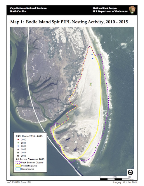
In 2015, nesting was identified at four sites: Bodie Island Spit on Bodie Island, Cape Point on Hatteras Island, North Ocracoke and South Point on Ocracoke Island (Appendix A, Maps 1, 2, 3, and 4 respectively). Staff located the first piping plover nest on Bodie Island since 2012 (Appendix A, Map 1). The first nest of the 2015 breeding season was discovered on April 19th and the last nest hatched on July, 1st.
Field technicians identified twelve breeding pairs which produced 17 known nests. Thirteen nests successfully hatched at least one chick. A total of 56 eggs were documented, of which 36 hatched for a hatch rate of 64%. The average incubation period was 27 days and ranged from 24 to 32 days (three nests were excluded from this calculation due to being found after a full clutch was laid). Incubation period begins when the last egg of the clutch is observed or on the second day after the penultimate egg is initially observed and ends when the first chick is observed completely free of its shell.
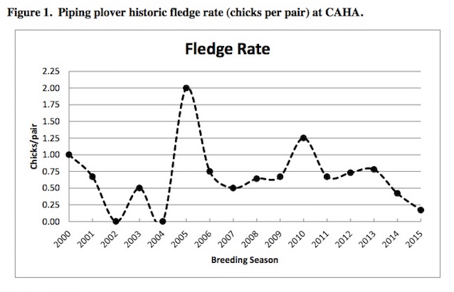
Four nests (23%) were lost prior to hatching and 34 chicks (94%) were lost prior to fledging (Table 1). Thirteen of 17 nests produced chicks and a total of two chicks fledged. Of the two broods that produced fledglings, the age at fledging at Cape Point was 27 days and the age of fledging on South Point was 30 days. Two chicks fledged from 12 breeding pairs yielding a fledge rate of 0.17 chicks fledged per breeding pair (Figure 1).
Table 1. Piping plover Nest and Chick Success at CAHA in 2015.
| Location | Breeding Pairs |
Total Nests |
Nests Hatched |
Nests Lost/ Abandoned |
Total Eggs |
Total Eggs Hatches |
Total Chicks Fledged |
Total Chicks Lost |
| Bodie Island Spit | 1 | 1 | 1 | 0 | 4 | 2 (50%) | 0 | 2 |
| Cape Point | 4 | 6 | 5 | 1 | 21 | 17 (81%) | 1 | 16 |
| South Beach | 1 | 1 | 0 | 1 | 4 | 0 (0%) | 0 | 0 |
| North Ocracoke | 1 | 3 | 1 | 2 | 9 | 4 (44%) | 0 | 4 |
| South Point | 5 | 6 | 6 | 0 | 18 | 13 (72%) | 1 | 12 |
| TOTAL | 12 | 17 | 13 | 4 | 56 | 36 | 2 | 34 |
Since 2000, fledge rates have ranged from 0.0 to 2.0 chicks per pair at CAHA. The mean rate from 2000-2014 was 0.73 chicks per pair. The fledge rate for 2015 was 0.17 which is the lowest fledge rate since 2004. Chick loss, as in previous years, was difficult to document. The majority of chick mortality occurred within three days post hatching with an average of 2.4 days (loss ranges are one to 11 days). Bodie Spit produced one nest with four eggs, of which, two eggs hatched (50% hatch rate). Of the unhatched eggs, one was lost to unknown causes and one egg was abandoned. Two chicks at Bodie Spit were lost to unknown causes. Cape Point had 81% hatch rate with four eggs lost (unknown cause) and 16 chicks lost to unknown cause; one chick fledged. On South Beach, four eggs were lost to unknown causes. North Ocracoke had a 44% hatch rate with five eggs lost (three to ghost crab depredation, two to overwash) and four chicks lost to unknown cause. South Point had a 72% hatch rate with 5 eggs lost to unknown causes, 12 chicks lost to unknown causes, and one chick fledged.
In 2015, Virginia Tech University began banding PIPL chicks and adults. This information will allow CAHA to better understand the geographic distribution of uniquely marked PIPL adults and chicks throughout CAHA, as well as Cape Lookout National Seashore to the south, and Pea Island National Wildlife Refuge, located within CAHA boundaries. An understanding of the breeding pair dynamics and the individual pair behaviors (i.e., preferred foraging areas, nest site selection, etc.) allow CAHA to predict how PIPL behaviors may affect user access to the seashore.
Predator Exclosures
U.S. Fish and Wildlife Service recommends the use of predator exclosure as a way of potentially increasing hatching success in areas with high densities of predators (USFWS, 1996). As in previous years, predator exclosures were used to protect the nests. After predator exclosures were installed, the nest was observed until one of the adult PIPL returned to the nest and resumed incubation. The average elapsed time before a bird accepted the exclosure was 20 minutes and ranged from 11 to 52 minutes. Predatory pressure within CAHA may vary due to the geographic location of each island. Bodie Spit is connected to the mainland by bridges which provide an effective wildlife corridor for larger mammalian predators (i.e. canids). Hatteras Island is connected to Bodie Spit by the Herbert C. Bonner Bridge, which allows for the expansion of larger predators. Ocracoke Island is accessible only by ferry and remains the only CAHA location relatively protected from the expansion of larger mammalian predators. This isolation reduces the likelihood of larger canids reaching the island. While access to the island could be gained by swimming across Hatteras or Ocracoke Inlets, strong currents likely preclude such immigration.
Chick Movement
During daily observations, field technicians documented foraging locations for PIPL chicks. Since chicks were not observed continuously from dawn to dusk or during the night, actual territories may be larger than depicted. When chicks were lost soon after hatching, no foraging territory outside the immediate vicinity of the nest could be established. A grid system with points located 75 meters apart was established at historical breeding territories at the beginning of the breeding season to aid staff in obtaining accurate locations for chicks. When chicks were observed, their locations were recorded relative to the grid points. The individual brood foraging areas designate the area in which the brood was observed on any given day until they fledged or were determined to be lost. At Cape Point, the PIPL chick moved approximately 190 m to its foraging grounds. The foraging grounds were near the mouth, east side and west side shorelines of the small salt pond (4.06 ha). This was used from 3 days old to 28 days old. The PIPL brood on South Point Ocracoke which fledged one chick made a straight line movement of 490m to a foraging area northwest of the nest to a tidal flat along the sound. Once the chicks established, they foraged in an area of approximately 6.25 ha.
Human Disturbance
Human disturbance, direct or indirect, can lead to the abandonment of nests and optimal breeding habitat, or loss of chicks. Throughout the 2015 breeding season, field staff documented 107 violations to closures with nesting shorebirds. Of these violations, 2 were documented in closures containing nesting PIPL or habitat protected for PIPL. These violations consisted of: 1 pedestrian, and 1 ORV. The numbers are conservative since sites are not monitored continuously, tracks are easily altered by weather and staff would not disturb an incubating adult or broods in order to document disturbance. It is important to note that most of the closures contained multiple species, including least terns, American oystercatchers, and PIPL. Most illegal entries were not witnessed, but documented based on vehicle, pedestrian, or tracks left in the sand. Since violations were primarily based on tracks, it is difficult to determine what the actual impact is on nesting shorebirds or chicks.
References
Byrne, M. W., J. C. DeVivo, J. M. Maxfield, C. J. Wright, and E. Thompson. 2009. Methods for monitoring migratory and wintering shorebirds in Southeast Coast Network Parks. Natural Resource Report NPS/SECN/NRR-2009/107. National Park Service, Fort Collins, Colorado.
National Park Service. 2010. Cape Hatteras National Seashore Off-Road Vehicle Management Plan and Environmental Impact Statement. U. S. Department of the Interior, National Park Service, Cape Hatteras National Seashore, North Carolina.
National Park Service. 2015. Environmental Assessment/Assessment of Effect: Review and Adjustment of Wildlife Protection Buffers. U. S. Department of the Interior, National Park Service, Cape Hatteras National Seashore, North Carolina.
U. S. Fish and Wildlife Service. 1996. Piping Plover (Charadrius melodus), Atlantic Coast Population, Revised Recovery Plan. USFWS Regional Office, Hadley, Massachusetts. Appendix F.
U. S. Fish and Wildlife Service. 2010. Biological opinion the Off-Road Vehicle Management Plan for Cape Hatteras National Seashore, Dare and Hyde Counties, North Carolina. U. S. Fish and Wildlife Service, Raleigh Field Office, Raleigh, NC. 156 pp.
Appendix A: Maps
Map 1: Bodie Island Spit PIPL Nesting Activity, 2010-2015
Map 2: Cape Point PIPL Nesting Activity, 2010-2015
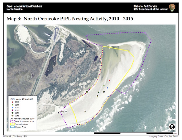
Map 3: North Ocracoke PIPL Nesting Activity, 2010-2015
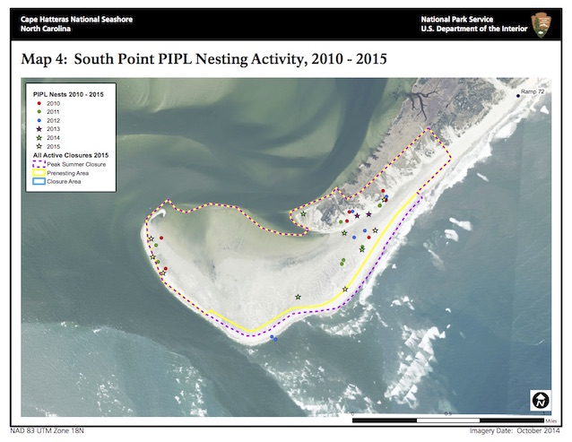
Map 4: South Point PIPL Nesting Activity, 2010-2015
Last updated: December 11, 2017
