Last updated: March 6, 2023
Article
Archeology of the “Mystery Islands” Nihoa and Mokumanamana

U.S. Fish and Wildlife Service
have shone a light on the islands’ significance to people of the past.
In 1857, King Kamehameha IV annexed Nihoa and Mokumanumanu into the Hawaiian kingdom. Twenty-eight years later, his daughter Princess (later Queen) Liliuokalani and 200 others took an exploratory visit to Nihoa. The Queen brought back a carved basalt bowl that she collected on the island. This bowl was one of many reminders of the people living on Nihoa centuries before, yet little else of the islands’ histories was known at that time.
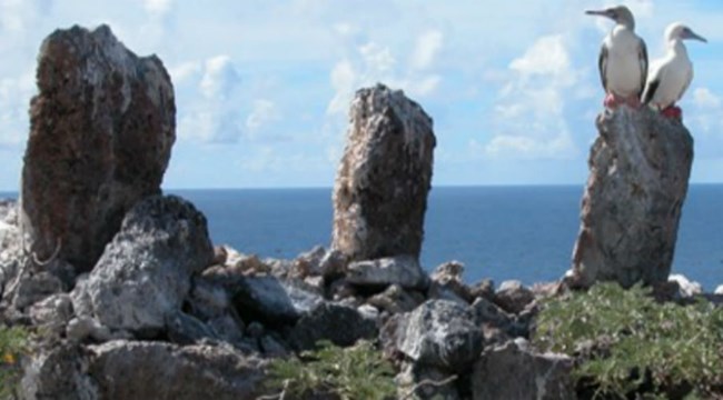
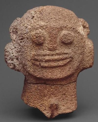
It took until 1923 for scholars of the Tanager Expedition to conduct the first archeological surveys of Nihoa and Mokumanumanu. The following year, Kenneth Emory from the Bishop Museum directed a second archeological study. His team recorded open habitation sites and cave shelters, agricultural terraces, and heiau (temples) on both islands. At the former sites, Emory’s crew uncovered hearths, stone tools (such as hammerstones, awls, sinkers, and fishhooks), and other domestic items including jars and bowls similar to the one collected by Queen Liliuokalani years earlier. Emory noted that heiau vastly outnumbered habitation sites on Mokumanamana. Many heiau were built in a specific form with a semi-circle of upright, carved stone images (ki’i) and a paved stone floor enclosed with a wooden or rock fence or wall (Kikiloi, 76.) Several contained coral offerings.

Metropolitan Museum of Art
Mokumanamana was an optimal place for these heiau. According to mo’olelo traditions, Wakea, the Sky Father, built a heiau with his hands for his ancestors when asking for their aid. The ritual sites on Mokumanamana were all found on its five hills, which naturally mimic Wakea’s cupped hand; indeed, the island’s name translates to the “island [temple] of fingers” (Kikiloi, 92). In addition, because of the island’s position within the Pacific Ocean, the sun is directly overhead on the summer and winter solstice. This phenomenon made the island a direct marker of the Hawaiian spiritual calendar. Therefore, by building heiau on Makumanamana, chiefs directly connected themselves with multiple forms of ritual power.
Unlike Mokumanamana, Nihoa contained several long-term habitation sites and agricultural terraces as well as heiau. It is likely that individuals in the past lived there year-round and helped produce the wood and other resources that supported the short-term yet essential ritual sites on Mokumanamana.
Today, Nihoa and Mokumanamana are listed on the State and National Registers of Historic Places. The islands are part of the Hawaiian Islands National Wildlife Refuge within the Papahanaumokuakea Marine National Monument. In 2010, Papahanaumokuakea was named a World Heritage Site. To protect these incredible resources, access to the islands is permitted for scientific, educational, or cultural purposes only.
Resources
Cultural Features: Monument Features and Papahanaumokuakea’s Archaeological Resources. Papahanaumokuakea Marine National Monument. National Ocean Service, Office of National Marine Sanctuaries, National Oceanic and Atmospheric Administration.Bishop Museum. Islands of Mystery: The Archaeology of Nihoa and Mokumanamana. Ka’elele (Summer 2016):17.
Brigham, William Tufts. Ancient Hawaiian Stone Implements. Issued April 1902. Memoirs of the Bernice Pauahi Bishop Museum of Polynesian Ethnology and Natural History, Volume I. Bishop Museum Press, 1899-1903.
Emory, Kenneth P. Archaeology of Nihoa and Necker Islands. Tanager Expedition No. 5, Bernice P. Bishop Museum Bulletin 53. Honolulu, 1928.
Kikiloi, Kekuewa Scott T. Kukulu Manamana: Ritual Power and Religious Expansion in Hawai’i: The Ethnohistorical and Archaeological Study of Mokumanamana and Nihoa Islands. Dissertation, University of Hawaii, 2012.
Mokumanamana (Necker Island). Hawaiian Islands National Wildlife Refuge. U.S. Fish and Wildlife Service.
Tags
- archeology
- archaeology
- aapi
- asian american and pacific islander heritage
- hawaii
- necker island
- mokumanamana island
- asian american and pacific islander history
- northwestern hawaiian islands
- papahanaumokuakea marine national monument
- hawaiian islands national wildlife refuge
- world heritage site
- village
- sacred site
- national monument
